When you click on links to various merchants on this site and make a purchase, this can result in this site earning a commission. Affiliate programs and affiliations include, but are not limited to, the eBay Partner Network.
Thank you!
If you do not wish to have your item(s) delivered on data disc(s), I can provide them on a flash drive and other means as well. Just let me know if a disc does not work for you and we can discuss delivery by other methods.
COMBINING SHIPPING COSTS
Are you purchasing multiple items? I will: a) combine all invoices before payment and charge shipping equivalent to one item, or b) refund all shipping costs in excess of one item after payment.
All derivative (i.e. change in media; by compilation) work from this underlying U.S. Government public domain/public release data is COPYRIGHT © GOVPUBS
$5.00 first class shipping in U.S. and rest of world.
Includes the Adobe Acrobat Reader for reading and printing publications.
Numerous illustrations and matrices.
Contains the following key public domain (not copyrighted) U.S. Government publication(s) on one CD-ROM in both Microsoft PowerPoint and Adobe Acrobat PDF file formats:
TITLE: Datums & Coordinate Systems, 58 pages (slides)
SLIDE TOPICS, SUBTOPICS and CONTENTS:
Datums & Coordinate Systems
Revenge of the Shift
ObjectiveIdentify different datumsIdentify different coordinate systems
Setting The Stage
GPS is rigid – collects one wayGIS is flexible – designed to share#1 reason GPS data doesn’t line up in GIS - coordinate system/datum mismatchHow do we fix it? – EducateCoordinate Systems
Latitude and LongitudeUniversal Transverse Mercator (UTM)
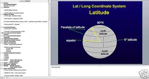
Lat / Long Coordinate System Latitude
Lat / Long Coordinate System Longitude
UTM Coordinate Systems
UTM Zones in North America
“Figure” of the Earth
Datum and Ellipsoids
Datum - represented by ellipsoidReference ellipsoid examples:
Clarke 1866
GRS 80
WGS 84
Common Geographic Clarke 1866 ellipsoid origin in Kansas
NAD27: Leaving Behind
GPS Datum: WGS 84
WGS84: WGS84 ellipsoid origin center of earth
Datum Adjustments
Known as Datum Adjustments or EpochsWGS84 (G1150) – most current version“Original” NAD83 = NAD83 (1986)
NAD83 (1992)
NAD83 (2002)
……Most Current NAD83
NAD83 (CORS96) (Epoch 2003.00)
Over Time Datums Have Grown Apart
Differences between Datums
NAD27 ≠ NAD83 (1986)
Shift Happens - Redmond OR 2005 Example
Differences between Datums
WGS84 = ITRF00
about 2cm
NAD83 (CORS96) ≠ WGS84
about 4.3 feet
Reference Frames
Differentially corrected GPS data are always in terms of the corrections source’s reference frame. In Arcata we are using CORS station data and therefore must apply the correct datum transform between the GPS data and your GIS
Mapping / Coordinate System
For Arcata BLM Office in Pathfinder OfficeReason Were Using NAD83 (CONUS) CORS96
When Do Datums/Coordinate Systems Matter?
PFO Map View
Coordinate system
Terrasync
Coordinate System
Export Utility
Shape Export Coordinate System
ArcGIS Catalog
Define Projection
ArcGIS
Data Frame Properties – Coordinate System Tab
GPS Datum Tips
Summary:
Check, check, check
ASK your GIS SpecialistGood handouts in /references
Conclusion
Now that you’ve learned there are differences it will be important that you learn how to…
Make it Match
Pre-Field Day 2
Datum Transforms
Friday’s Test against TruthMatching Datums
Revenge of the Shift
Objective
Overview of Matching Datums and Coordinate Systems in Pathfinder Office and Data Transfer
Taking “GIS” out in the Field
Rasters
VectorsAll require a projection (coordinate system) defined ahead of timeMatching Data Steps
Know what it is – Metadata helpsTell Pathfinder Office the correct Datum and Coordinate System
When Do Datums/Coordinate Systems Matter?
PFO Map View
Coordinate system
Terrasync
Coordinate System
Export Utility
Shape Export Coordinate System
ArcGIS Catalog
Define Projection
ArcGIS
Data Frame Properties – Coordinate System Tab
Today’s Background Image
Humboldt Campus Map
PDF obtained from Website
Converted to TIFF
Co-registered 12 control points between Ortho~ Depending on accuracy of Ortho, maybe +/- 20 meters in horizontal accuracy
Coordinate System and Datum
Next Step
Data Transfer background imagery to the GeoCE deviceDatum Transforms
Objective
Identify the proper reference frame for different differential sourcesLearn how to apply the correct datum transformation inside PFO
Prior to this Presentation
You occupied “Truth”
Collected at least one Point feature
Now we can compare!
Mapping Grade GPS Accuracy
Verification of accuracy is essential to gain confidenceWe have to ensure we transform the data correctly to GIS
Accuracy Slides
Using Real Data.
Today is Your Chance to Test
First Some Background NAD83 Developed Using WGS84
Over Time Datums Have Grown Apart
Datum Adjustments
Known as Datum Adjustments or EpochsWGS84 (G1150) – most current versionMost Current NAD83
NAD83 (CORS96) (Epoch 2003.00)
Differences between Datums
WGS84 = ITRF00
about 2cm
NAD83 (CORS96) ≠ WGS84
about 4.3 feet
Reference Frames
CORS Post Process = ITRF00
Autonomous GPS = WGS84 = ITRF00
WAAS = ITRF00
NDGPS (Radio DGPS) = NAD83 (CORS96)
OMNISTAR (Satellite DGPS) = NAD83 (CORS96)
NAD 83 (CORS96) to WGS-84 (G1150)
Reference
Locate this support doc and follow along
2nd to last reference in Training Used Scenario 2
Since our Reference Frame is CORS
Our GPS data is corrected against a source that is in WGS84 or ITRF00And our GIS is in NAD83We therefore define an ITRF00 to NAD83 Transform
Export Out as NAD83 (CONUS) CORS96
The reason behind our class standard
To Keep Shifts at Bay
Verify reference frame of differential source To Keep Shifts at Bay
Apply the correct datum transform before the Export depending on your GIS needs
Summary
Identified the proper reference frame for different differential sourcesLearned how to apply the correct datum transformation inside PFOKeep Shifts at Bay by verifying and using the right transform
If You Use WAAS?
If You Use Coast Guard Beacon?