When you click on links to various merchants on this site and make a purchase, this can result in this site earning a commission. Affiliate programs and affiliations include, but are not limited to, the eBay Partner Network.
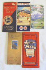
Being offered is a mixed lot of 5 vintage travelroad maps. Included in the lot are, 1) isa vintage city fold out map. It istitled Official Arrow City Map by the Pikes Peak News Agency. The map is of Colorado Springs, Colorado, andhas Special Tourist Information. The mapshows all streets main thorough-fares, highways, railroads, principal municipalbuildings, and points of interest. Ithas sections on the Air Force Academy along with Colorado College. The map is an insert to covers. The covers do show age and wearing with edgeand corner creases, bruises, soiling, and tiny edge tears. The map itself has some corner and edgecreases in places and some small spot tears along the folding or creasedportion. The map folded out is approx.42" by 28". I am not sure howto grade something like this so have taken close-up pics to help assess theitems condition, what you see is what you get.2) is a vintage gas stationtravel vacation road map. The map is ofNew Mexico and was put out by the Standard Oil Company, Chevron gasstations. This is a pre interstatehighway road map and shows the old route 66 which was a major road on the wayto the west coast. There is also asmaller map of the United States, and has maps of Santa Fe andAlbuquerque. There are radio stations,points of interest, and touring map. Themap is approx. 18" by 27". Icould not find a copyright date but the map shows the population of New Mexicoas 681,187. I entered this population inGoogle AI and was informed, "New Mexico had a population of 681,187 onApril 1, 1950, according to the 1950 United States Census." The map does show age related wearing in places. There are small or tiny tears in places alongthe crease lines but is overall attached and intact. There is some slight soiling in places butlooks clean and the colors remain good.I would say this map was seldom used as there are no major rips, tears,or stains. 3) is a vintage, fold out, Iowaroad map. The map was put out byStandard Oil Indiana and is dated 1929, and a map of Iowa. These were for free at gas or servicestations. The map does show age andwearing. The covers have surface tearsin places, abrasions, creasing, and tiny edge tears, which overall, the entiremap is in similar condition. The arepartial tears where the crease folds are located. The map fold out is approx. 23 1/2" by18'. I am not sure how to gradesomething like this so have taken close-up pics to help assess the itemscondition, what you see is what you get.4) is a vintage road of Colorado.This was published by the Colorado highway department and given free attourist and travel centers. The map isfrom 1970 and shows places and points of interest for the Coloradotourist. The map does show age andwearing with folds and creases in places but is intact. The map folded up is approx. 7 3/8” by 3 3/4”. 5) This map is more contemporary and titledAmerica’s Byways, All American Roads & National Scenic Byways. There is a map of the US along with what looklike National Parks, historic places, and travel destinations with backgroundinformation on the places. The map doesshow age and wearing with folds and creases but is in nice shape. The map is approx. 9” by 4”.
Please feel free to contact me with any questionsabout my items. I stand behind my merchandise and provide a full refund ifitems are not as described. Purchasewith confidence as I do want customers to be satisfied with theirpurchase. Check-out my other items forsale and sale. Buyer pays a flatshipping rate. I do combine items tosave on shipping costs. Please let meknow ahead of time.
Check out my shipping terms. PLEASE NOTE:Shipping items could take up to 5 business days, or 7 regular days oncepayment is made due to being an old man with arthritis, back issues, and a hostof other medical problems. I will try mybest to get the item out sooner. Thanksfor your business.