When you click on links to various merchants on this site and make a purchase, this can result in this site earning a commission. Affiliate programs and affiliations include, but are not limited to, the eBay Partner Network.
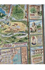
Vintage 1970 Dick Bibler map
Illustrated Historical Map of The Monterey Bay and Peninsula
Large 40x36 inches
Map has never been framed or displayed
Color quality is true to original printing
Map is in very good condition
2" wear spot on lower right boarder from tube storage, (see photo)
Colorful pictorial map, issued for the Monterey Bicentennial of 1970
Shows tourist attractions, major buildings, roads, and activities of tourists and local people such as golfing, surfing, hiking, etc.
The decorative border depicts vignette illustrations of historic sites and people
The inset map of the old town area, has a numbered guide for a Walking Tour and an Auto Tour.