When you click on links to various merchants on this site and make a purchase, this can result in this site earning a commission. Affiliate programs and affiliations include, but are not limited to, the eBay Partner Network.
48 x 36 in.
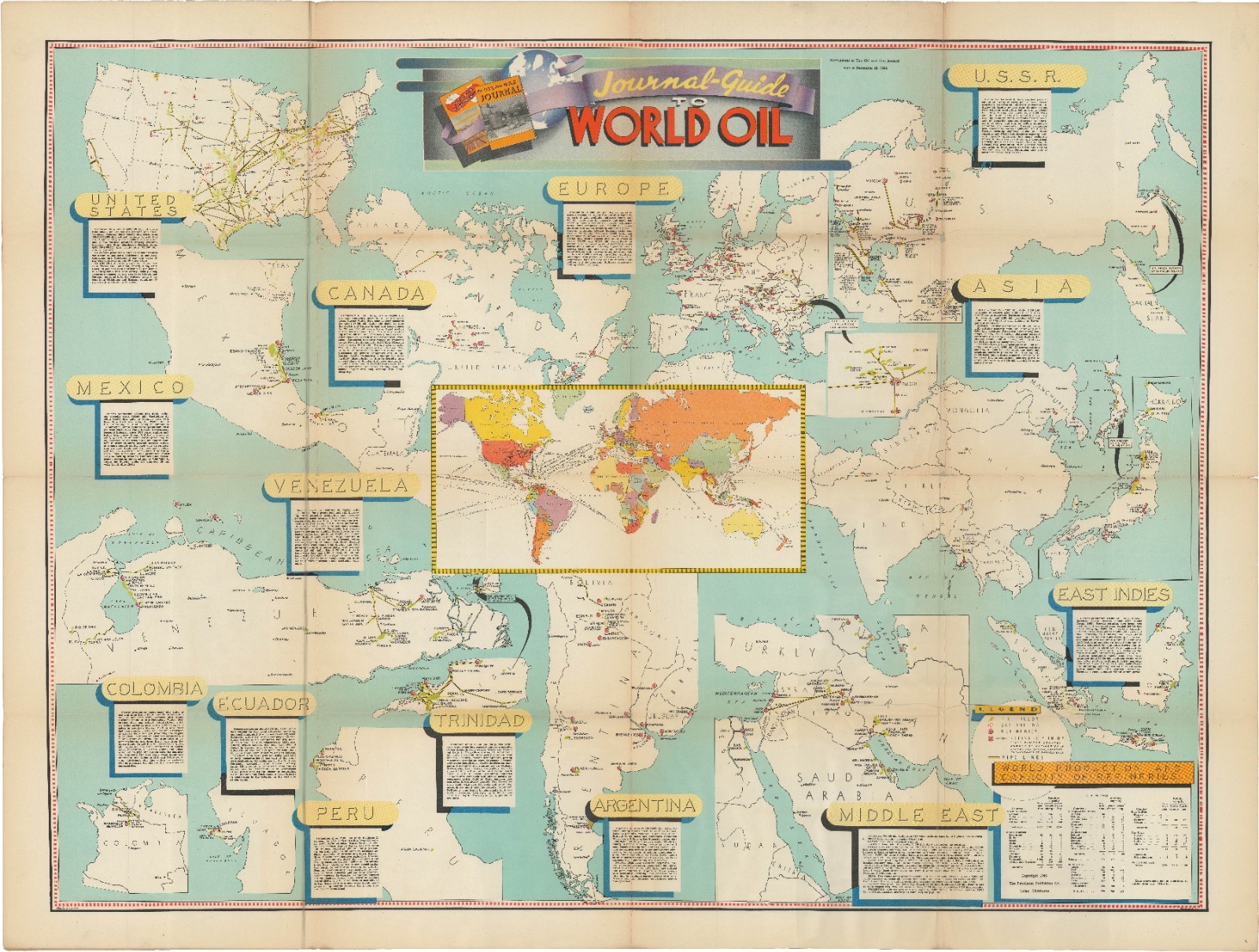
Journal-Guide to World Oil.
Published in 1946 as a supplement to the December 28, 1946 issue of the Petroleum Publishing Co.'sOil & Gas Journal, this map presents a comprehensive visual and statistical overview of the global petroleum industry at a pivotal historical moment. The map is structured around a central world projection highlighted in warm orange and green tones, framed by over a dozen detailed regional inset maps and explanatory text boxes. These regional panels highlight major producing areas across North and South America (including the United States, Canada, Mexico, Venezuela, Colombia, Peru, Trinidad, and Argentina), Western and Eastern Europe, the U.S.S.R., Asia, the East Indies, and the Middle East. Cartographic elements depict oil field locations, pipeline networks, refinery clusters, and shipping routes, while statistical tables in the lower-right corner compile detailed data on global reserves, refining capacity, and regional production output.
The map's publication in 1946 places it in the immediate aftermath of World War II, a conflict that definitively demonstrated that modern industrial and military power relied fundamentally on petroleum. During the war, oil fueled mechanized ground divisions, massive naval fleets, and strategic aviation networks. As nations shifted from military mobilization to peacetime reconstruction, global demand for oil and gas accelerated. This energy was crucial for rebuilding war-torn infrastructure across Europe and East Asia, as well as driving the postwar economic boom in the United States and North America—a expansion characterized by rapid suburban development, expanding highway networks, and growing industrial automation.
Geopolitically, the guide captures a major transition in the geography of global energy. While the United States is depicted as the premier producing and refining power—having supplied the majority of the Allied war effort's fuel—the map clearly signals the rising strategic importance of foreign reserves, particularly in Venezuela and the Middle East (highlighting fields in Saudi Arabia, Iraq, Iran, and Kuwait). The detailed mapping of Middle Eastern concessions and transport corridors reflects the early stages of a shift in international energy dynamics, as Western governments and corporate cartels increasingly prioritized access to overseas crude, laying the groundwork for key geopolitical rivalries of the Cold War era.