When you click on links to various merchants on this site and make a purchase, this can result in this site earning a commission. Affiliate programs and affiliations include, but are not limited to, the eBay Partner Network.
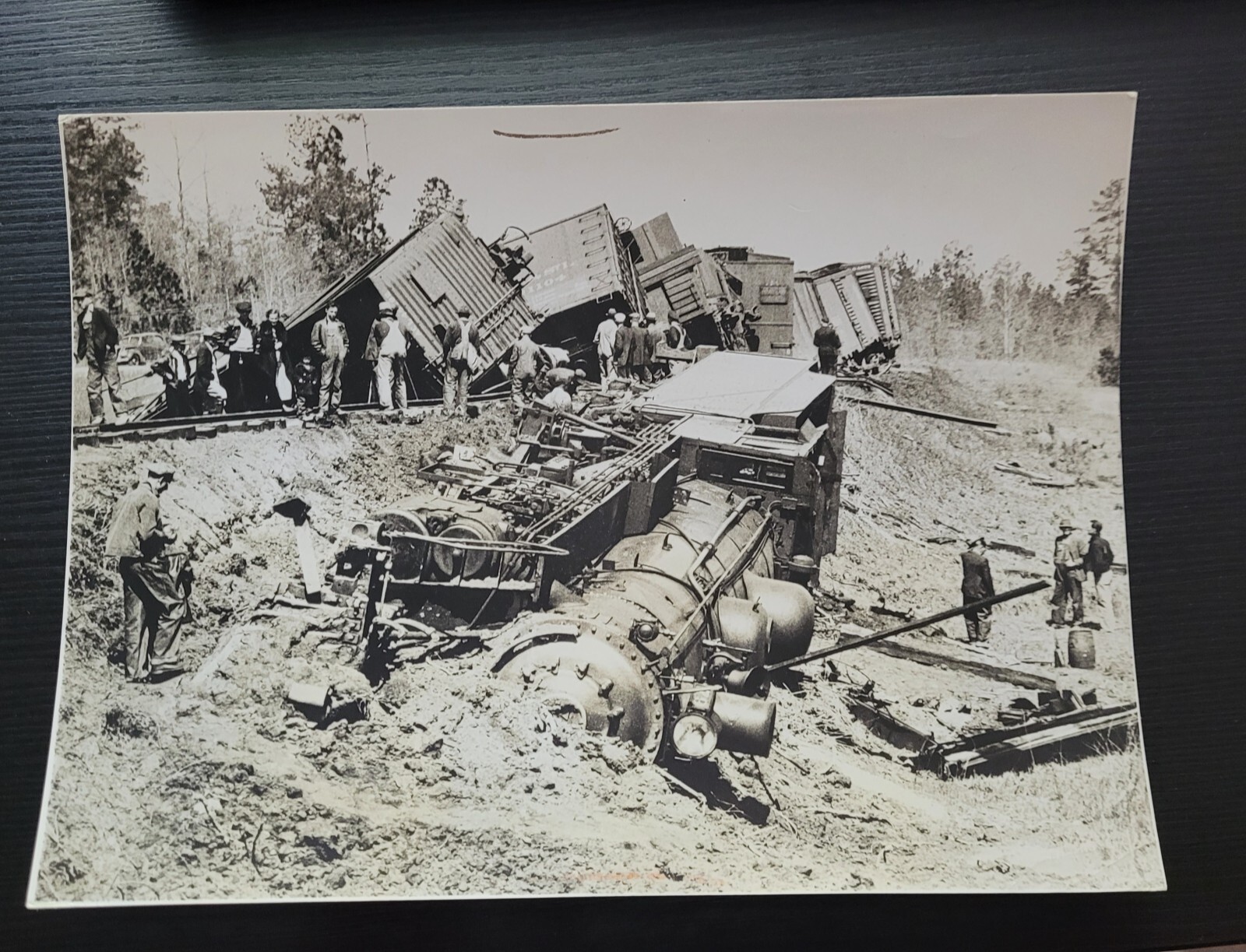
A VINTAGE ORIGINAL 6X8 INCH PHOTO OF A BEN HILL, GEORGIA TRAIN WRECK FROM 1937 MEASURING APPROX~ 6 3/8 X 8 3/4 INCHES
World PhotoWRECK IN GEORGIA. A train carrying both freight and passenger cars plunged over a twenty-foot embankment after plowingthrough a broken rail two miles from Ben Hill, Ga. One man, riding in the engine cab, was buried under the coal from the train\'stender and seriously injured,
Fitzgerald is a city in and the county seat of Ben Hill County in the south central portion of the U.S. state of Georgia.[6] As of 2020, its population was 9,006.[7] It is the principal city of the Fitzgerald micropolitan statistical area, which includes all of Ben Hill and Irwin counties.
A small portion of Fitzgerald is in Irwin County.[8]
HistoryFitzgerald was developed in 1895 by Philander H. Fitzgerald, an Indianapolis newspaper editor. A former drummer boy in the Union Army during the Civil War, he founded it as a community for war veterans–both from the Union and from the Confederacy.[9] The majority of the first citizens (some 2700) were Union veterans.[10] It was incorporated on December 2, 1896.[11] The town is located less than 15 miles (24 km) from the site where Confederate president Jefferson Davis was captured on May 10, 1865.
Fitzgerald was an early planned city. It was laid out as a square, with intersecting streets dividing it into four wards. Each ward was divided into four blocks and each block had sixteen squares.[12] The first two streets running north–south on the west side of the city were named after Confederate generals Lee and Johnston, whereas the first two on the east side were named after Union generals Grant and Sherman.[13]
After about a year, the residents planned a Thanksgiving harvest parade. Separate Union and Confederate parades were planned. But when the band struck up to play, the Confederates joined the Union veterans to march as one under the US flag.[14] At the time there was increasing reconciliation nationwide between white soldiers of the North and South; historian David Blight notes that outstanding issues of race were pushed aside. In this era southern states had already begun to pass new constitutions that raised barriers to voter registration, following Mississippi\'s in 1890, and essentially disenfranchised most freedmen and many poor whites. By 1900, Fitzgerald was a sundown town, prohibiting African Americans from living there.[15]
In recent years the unofficial, and sometimes controversial, mascot of the city has become the red junglefowl, a wild chicken native to the Indian subcontinent. In the late 1960s, a small number were released into the woods surrounding the city and they thrive to this day.[16] In 2019, work began on a 62-foot (19 m) tall topiary statue of a chicken.
GeographyFitzgerald is located in Southeast Georgia at 31°42′56″N 83°15′23″W (31.715432, -83.256464).[17] U.S. Route 129 passes through the center of the city, leading north to Abbeville, Hawkinsville, and eventually Macon, and south to Ocilla, Nashville, and Lakeland. U.S. Route 319 also passes through Fitzgerald, leading northeast to McRae and Dublin and southwest to Tifton.
According to the United States Census Bureau, the city has a total area of 9.0 square miles (23.3 km2), of which 8.8 square miles (22.9 km2) is land and 0.15 square miles (0.4 km2), or 1.64%, is water.[18]
ClimateClimate data for Fitzgerald, Georgia, 1991–2020 normals, extremes 1898–2006Month Jan Feb Mar Apr May Jun Jul Aug Sep Oct Nov Dec YearRecord high °F (°C) 84(29) 89(32) 95(35) 95(35) 102(39) 104(40) 106(41) 104(40) 102(39) 97(36) 92(33) 85(29) 106(41)Mean daily maximum °F (°C) 60.1(15.6) 64.1(17.8) 70.6(21.4) 78.0(25.6) 84.8(29.3) 89.4(31.9) 92.4(33.6) 90.8(32.7) 86.8(30.4) 79.5(26.4) 69.3(20.7) 62.5(16.9) 77.4(25.2)Daily mean °F (°C) 49.3(9.6) 52.7(11.5) 58.9(14.9) 65.6(18.7) 73.5(23.1) 79.6(26.4) 82.5(28.1) 81.1(27.3) 76.3(24.6) 67.5(19.7) 57.4(14.1) 51.5(10.8) 66.3(19.1)Mean daily minimum °F (°C) 38.6(3.7) 41.4(5.2) 47.3(8.5) 53.3(11.8) 62.3(16.8) 69.8(21.0) 72.5(22.5) 71.3(21.8) 65.9(18.8) 55.6(13.1) 45.5(7.5) 40.5(4.7) 55.3(12.9)Record low °F (°C) 4(−16) −1(−18) 17(−8) 32(0) 42(6) 50(10) 59(15) 55(13) 41(5) 29(−2) 18(−8) 7(−14) −1(−18)Average precipitation inches (mm) 4.08(104) 3.77(96) 4.61(117) 3.76(96) 2.62(67) 4.64(118) 4.38(111) 5.63(143) 3.42(87) 2.98(76) 2.83(72) 4.92(125) 47.64(1,212)Average precipitation days (≥ 0.01 in) 8.5 7.3 8.4 5.9 5.8 11.6 9.6 10.2 6.8 5.7 6.6 6.5 92.9Source 1: NOAA[19]Source 2: XMACIS2[20]DemographicsHistorical populationCensus Pop. Note %±1900 1,817 —1910 5,795 218.9%1920 6,870 18.6%1930 6,412 −6.7%1940 7,388 15.2%1950 8,130 10.0%1960 8,781 8.0%1970 8,187 −6.8%1980 10,187 24.4%1990 8,612 −15.5%2000 8,758 1.7%2010 9,053 3.4%2020 9,006 −0.5%U.S. Decennial Census[21]Fitzgerald racial composition as of 2020[22]Race Num. Perc.White (non-Hispanic) 3,392 37.66%Black or African American (non-Hispanic) 4,804 53.34%Native American 38 0.42%Asian 74 0.82%Other/Mixed 295 3.28%Hispanic or Latino 403 4.47%At the 2020 United States census, there were 9,006 people, 3,346 households, and 1,932 families residing in the city.
By 2022 a part of the city was in Irwin County, but no people lived in that portion.[23]
Arts and cultureThe Dorminy-Massee House is now operated as a bed and breakfast. J. J. (Captain Jack) Dorminy built it in 1915 for his family; the two-story, colonial-style home is listed on the National Register of Historic Places.[24]
The Blue and Gray Museum, located in the town\'s AB&A 1908 railroad depot, houses several artifacts that tell the story of the town\'s founding.[25] The town also has a city government owned art gallery located in the Carnegie library on the edge of downtown.
Government and infrastructure
Fitzgerald Post Office
Ben Hill County CourthouseThe U.S. Postal Service operates the Fitzgerald Post Office. The city is the county seat, hosting the Ben Hill County Courthouse.
Education
Ben Hill County School District headquarters
Fitzgerald High SchoolThe Ben Hill County School District, which includes all of Ben Hill County,[26] conducts pre-school to grade twelve, and consists of one pre-school, one primary school, an elementary school, a middle school, and a high school.[27] The district has 217 full-time teachers and over 3,395 students.[28]
Ben Hill County PreKBen Hill County Primary SchoolBen Hill County Elementary SchoolBen Hill County Even StartBen Hill County Middle SchoolFitzgerald High School College and Career AcademyWhile the Irwin County portion is in the Irwin County School District,[29] as of 2022 no people live in that portion.[23]
Wiregrass Georgia Technical College – Ben Hill-Irwin Campus is located on the southern end of the county.
Media
This section does not cite any sources. Please help improve this section by adding citations to reliable sources. Unsourced material may be challenged and removed. (September 2022) (Learn how and when to remove this message)WRDO Real Radio 96.9Herald Leader Newspaper (Fitzgerald)WSWG, CBS TVCW44, CW TVWSWG2, My Network TVWOKA Dixie Country 106.7WOBB B-100WSIZ Radio MyFM 102.3 (Fitzgerald) @ 99.9 (Douglas)Minor league baseball teams
This section does not cite any sources. Please help improve this section by adding citations to reliable sources. Unsourced material may be challenged and removed. (July 2009) (Learn how and when to remove this message)Fitzgerald was home to a minor league baseball team in the Georgia State League from 1948, the league\'s first season of operation, through 1952. The team was called the Fitzgerald Pioneers. The club had no affiliation with any major league club during the five seasons of operation in the Georgia State League. After the 1952 season, the Fitzgerald Pioneers relocated to Sandersville and became the Sandersville Wacos, which were affiliated with the Milwaukee Braves for the 1953 season. The team ended their last season in 1956, under different affiliation.
Fitzgerald got a replacement team for the Pioneers in 1953 when the Moultrie Giants of the Georgia–Florida League moved to town. The Moultrie club was a charter member of the Georgia–Florida League when it began operations in 1946. After relocating to Fitzgerald and becoming an affiliate of the Cincinnati Redlegs, the new edition of the Fitzgerald Pioneers lasted one season (1954) saw the team name changed to the Fitzgerald Redlegs. After two years in Fitzgerald, the club returned to Moultrie. It ceased operating in 1958 under the name Brunswick Phillies.
After the Fitzgerald Redlegs left, the city was without a team for the 1955 season. The next year the Cordele club relocated to Fitzgerald after ten seasons in Cordele. They changed affiliation back to what were now called the Kansas City A\'s, and the Fitzgerald A\'s played for the 1956 season. In 1957, the club again changed its affiliation, to the Baltimore Orioles; the club was known as the Fitzgerald Orioles for the 1957 season. The Fitzgerald team relocated to Dublin, Georgia after the 1957 season and remained a Baltimore Orioles farm team; they played as the Dublin Orioles for the Georgia–Florida League\'s last year of operation. Fitzgerald has not had a minor league team in the 63 years since.
Notable peopleMorris B. Abram, president of Brandeis University and civil rights leaderBrainard Cheney, authorNeal Colzie, NFL defensive backGeneral Raymond G. Davis, USMC, World War II hero, Korean War Medal of Honor recipient, Commander of the 3rd Marine Division in 1968–69 in Vietnam, and Assistant Commandant of the Marine Corps 1971–72Abner Jay, blues musicianFrances Mayes, authorCharlie Paulk, seventh pick of 1968 NBA draftJason Poe, NFL offensive guardJoe Reliford, youngest professional baseball playerLecitus Smith, NFL guardForrest Towns, 1936 Summer Olympics track starJemea Thomas, former NFL cornerbackMary Verner, politician, Mayor of Spokane, WashingtonSee alsoList of sundown towns in the United States
Ben Hill County is a county located in the U.S. state of Georgia. As of the 2020 census, the population was 17,194.[1] The county seat is Fitzgerald.[2] The county was organized in 1906. It is named after Benjamin Harvey Hill, a former Confederate and United States Senator.[3]
Ben Hill County comprises the Fitzgerald micropolitan statistical area. The Ben Hill County Courthouse and Ben Hill County Jail are listed on the National Register of Historic Places.
HistoryBen Hill County was organized in 1906.[4] It was created from Irwin and Wilcox counties.[5]
GeographyAccording to the U.S. Census Bureau, the county has a total area of 254 square miles (660 km2), of which 250 square miles (650 km2) is land and 3.8 square miles (9.8 km2) (1.5%) is water.[6]
The majority of Ben Hill County, its northern and eastern portions, are located in the Lower Ocmulgee River sub-basin of the Altamaha River basin. The northwestern corner of the county, east of Rebecca, is located in the Alapaha River sub-basin of the Suwannee River basin. The southeastern corner of the county, east of Fitzgerald, is located in the Satilla River sub-basin of the St. Marys-Satilla River basin.[7] Ben Hill County is part of the Southeast Georgia region.
Major highwaysU.S. Route 129U.S. Route 319State Route 11State Route 90State Route 107State Route 125State Route 182State Route 206State Route 215State Route 233Adjacent countiesWilcox County - northTelfair County - northeastCoffee County - eastIrwin County - southTurner County - westCommunitiesCityFitzgerald (county seat)Unincorporated communitiesBowen\'s MillQueenslandDemographicsHistorical populationCensus Pop. Note %±1910 11,863 —1920 14,599 23.1%1930 13,047 −10.6%1940 14,523 11.3%1950 14,879 2.5%1960 13,633 −8.4%1970 13,171 −3.4%1980 16,000 21.5%1990 16,245 1.5%2000 17,484 7.6%2010 17,634 0.9%2020 17,194 −2.5%2023 (est.) 17,128 [8] −0.4%U.S. Decennial 1930-1940[13]1940-1950[14] 1960-1980[15]1980-2000[16] 2010[17]Ben Hill County racial composition as of 2020[18]Race Num. Perc.White (non-Hispanic) 9,219 53.62%Black or African American (non-Hispanic) 6,222 36.19%Native American 57 0.33%Asian 116 0.67%Other/Mixed 526 3.06%Hispanic or Latino 1,054 6.13%In 2000, there were 17,484 people, 6,673 households, and 4,631 families living in the county.[19] The population density was 69 inhabitants per square mile (27/km2). There were 7,623 housing units at an average density of 30 per square mile (12/km2). In 2010, there were 17,634 people, 6,794 households, and 4,730 families living in the county.[20] By the 2020 United States census, there were 17,194 people, 6,443 households, and 4,019 families residing in the county.
In 2000, the median income for a household in the county was $27,100, and the median income for a family was $33,023. Males had a median income of $26,750 versus $19,547 for females. The per capita income for the county was $14,093. 22.30% of the population and 18.70% of families were below the poverty line. Out of the total people living in poverty, 33.30% are under the age of 18 and 17.60% are 65 or older. In 2010, the median income for a household in the county was $30,134 and the median income for a family was $35,868. Males had a median income of $32,613 versus $23,320 for females. The per capita income for the county was $15,529. About 22.7% of families and 26.9% of the population were below the poverty line, including 39.0% of those under age 18 and 16.3% of those age 65 or over.[21] According to the 2022 American Community Survey, the county\'s median household income was $38,255 with a per capita income of $22,625. An estimated 26.5% of the county lived at or below the poverty line.[22]
Religiously, the Association of Religion Data Archives in 2020 denoted Christianity as the predominant religion, being part of the Bible Belt.[23] Among its Christian population, the majority formed the Southern Baptist Convention, and the Baptist tradition was the county\'s dominant Christian affiliation. The National Baptist Convention, USA was the second-largest Baptist denomination in Ben Hill County. One notable non-Christian religion for the county has been the Baha\'i Faith.
EducationThe Ben Hill County School District operates schools serving the county.
Ben Hill PreschoolBen Hill County Primary SchoolBen Hill County Elementary SchoolBen Hill County Middle SchoolFitzgerald High SchoolPoliticsUnited States presidential election results for Ben Hill County, Georgia[24]Year Republican Democratic Third party(ies)No. % No. % No. %2020 4,111 62.63% 2,393 36.46% 60 0.91%2016 3,739 62.99% 2,101 35.39% 96 1.62%2012 3,396 56.88% 2,512 42.08% 62 1.04%2008 3,417 56.46% 2,590 42.80% 45 0.74%2004 3,331 60.07% 2,180 39.31% 34 0.61%2000 2,381 51.08% 2,234 47.93% 46 0.99%1996 1,516 37.08% 2,198 53.77% 374 9.15%1992 1,476 33.06% 2,348 52.60% 640 14.34%1988 2,005 51.17% 1,867 47.65% 46 1.17%1984 2,313 55.44% 1,859 44.56% 0 0.00%1980 1,459 35.87% 2,544 62.55% 64 1.57%1976 814 24.95% 2,449 75.05% 0 0.00%1972 2,104 74.96% 703 25.04% 0 0.00%1968 661 19.61% 877 26.02% 1,833 54.38%1964 2,089 57.82% 1,523 42.15% 1 0.03%1960 558 22.88% 1,881 77.12% 0 0.00%1956 554 20.49% 2,150 79.51% 0 0.00%1952 697 25.39% 2,048 74.61% 0 0.00%1948 223 11.76% 1,438 75.84% 235 12.39%1944 190 15.36% 1,046 84.56% 1 0.08%1940 181 13.00% 1,206 86.64% 5 0.36%1936 146 11.28% 1,147 88.64% 1 0.08%1932 85 7.62% 1,026 91.94% 5 0.45%1928 460 31.38% 1,006 68.62% 0 0.00%1924 150 17.71% 507 59.86% 190 22.43%1920 232 29.94% 543 70.06% 0 0.00%1916 134 17.43% 627 81.53% 8 1.04%1912 263 31.61% 535 64.30% 34 4.09%TransportationFitzgerald Municipal Airport is a public use airport located 2 miles southwest of Fitzgerald.See alsoflag State of Georgia portalNational Register of Historic Places listings in Ben Hill County, GeorgiaList of counties in Georgia
Georgia is a state in the Southeastern region of the United States. It borders Tennessee to the northwest, North Carolina to the north, South Carolina to the northeast, the Atlantic Ocean to the southeast, Florida to the south, and Alabama to the west. Of the 50 United States, Georgia is the 24th-largest by area and eighth most populous. According to the U.S. Census Bureau, its 2023 estimated population was 11,029,227.[2] Atlanta, a global city, is both the state\'s capital and its largest city. The Atlanta metropolitan area, with a population of more than 6.3 million people in 2023, is the sixth most populous metropolitan area in the United States and contains about 57% of Georgia\'s entire population. Other major metropolitan areas in the state include Augusta, Savannah, Columbus, and Macon.[5]
The Province of Georgia was created in 1732 and first settled in 1733 with the founding of Savannah. Georgia became a British royal colony in 1752. It was the last and southernmost of the original Thirteen Colonies to be established.[6] Named after King George II of Great Britain, the Georgia Colony covered the area from South Carolina south to Spanish Florida and west to French Louisiana at the Mississippi River. On January 2, 1788, Georgia became the fourth state to ratify the United States Constitution.[7] From 1802 to 1804, western Georgia was split to form the Mississippi Territory, which later was admitted as the U.S. states of Alabama and Mississippi. Georgia declared its secession from the Union on January 19, 1861, and was one of the original seven Confederate States. Following the Civil War, it was the last state to be restored to the Union, on July 15, 1870.[7] In the post-Reconstruction era of the late 19th century, Georgia\'s economy was transformed as a group of prominent politicians, businessmen, and journalists, led by Henry W. Grady, espoused the \"New South\" philosophy of sectional reconciliation and industrialization.[8] During the mid-20th century, several people from Georgia, most notably Martin Luther King Jr., were prominent leaders during the civil rights movement.[7] Atlanta was selected as host of the 1996 Summer Olympics, which marked the 100th anniversary of the modern Olympic Games. Since 1945, Georgia has seen substantial population and economic growth as part of the broader Sun Belt phenomenon. From 2007 to 2008, 14 of Georgia\'s counties ranked among the nation\'s 100 fastest-growing.[9]
Georgia is defined by a diversity of landscapes, flora, and fauna. The state\'s northernmost regions include the Blue Ridge Mountains, part of the larger Appalachian Mountain system. The Piedmont plateau extends from the foothills of the Blue Ridge south to the Fall Line, an escarpment to the Coastal Plain defining the state\'s southern region. Georgia\'s highest point is Brasstown Bald at 4,784 feet (1,458 m) above sea level; the lowest is the Atlantic Ocean . With the exception of some high-altitude areas in the Blue Ridge, the entirety of the state has a humid subtropical climate. Of the states entirely east of the Mississippi River, Georgia is the largest in land area.[10]
HistoryMain article: History of Georgia (U.S. state)Before settlement by European colonists, Georgia was inhabited by the mound building cultures. The Province of Georgia was founded by British General James Oglethorpe at Savannah on February 12, 1733, a year after its creation as a new British colony.[11] It was administered by the Trustees for the Establishment of the Colony of Georgia in America under a charter issued by (and named for) King George II. The Trustees implemented an elaborate plan for the colony\'s settlement, known as the Oglethorpe Plan, which envisioned an agrarian society of yeoman farmers and prohibited slavery. The colony was invaded by the Spanish in 1742, during the War of Jenkins\' Ear. In 1752, after the government failed to renew subsidies that had helped support the colony, the Trustees turned over control to the crown. Georgia became a crown colony, with a governor appointed by the king of Great Britain.[12]
The Province of Georgia was one of the Thirteen Colonies that revolted against British rule in the American Revolution by signing the 1776 Declaration of Independence. The State of Georgia\'s first constitution was ratified in February 1777. Georgia was the 10th state to ratify the Articles of Confederation on July 24, 1778,[13] and was the 4th state to ratify the United States Constitution on January 2, 1788.[14]Slaves with the cotton they had picked. Georgia, c. 1850After the Creek War (1813–1814), General Andrew Jackson forced the Muscogee (Creek) tribes to surrender land to the state of Georgia, including in the Treaty of Fort Jackson (1814), surrendering 21 million acres in what is now southern Georgia and central Alabama, and the Treaty of Indian Springs (1825).[15] In 1829, gold was discovered in the North Georgia mountains leading to the Georgia Gold Rush and establishment of a federal mint in Dahlonega, which continued in operation until 1861. The resulting influx of American settlers put pressure on the federal U.S. government to take land from the Cherokee Nation. In 1830, President Andrew Jackson signed into law the Indian Removal Act, sending many eastern Indian nations to reservations in present-day Oklahoma, including all of Georgia\'s tribes. Despite the Supreme Court\'s ruling in Worcester v. Georgia (1832) that U.S. states were not permitted to redraw Indian boundaries, President Jackson and the state of Georgia ignored the ruling. In 1838, his successor, Martin Van Buren, dispatched federal troops to gather the tribes and deport them west of the Mississippi. This forced relocation, known as the Trail of Tears, led to the death of more than four thousand Cherokees.The Battle of Kennesaw Mountain, 1864In early 1861, Georgia joined the Confederacy (with secessionists having a slight majority of delegates)[16] and became a major theater of the Civil War. Major battles took place at Chickamauga, Kennesaw Mountain, and Atlanta. In December 1864, a large swath of the state from Atlanta to Savannah was destroyed during General William Tecumseh Sherman\'s March to the Sea. 18,253 Georgian soldiers died in service, roughly one of every five who served.[17] In 1870, following the Reconstruction era, Georgia became the last Confederate state to be restored to the Union.\"Colored\" waiting room sign in 1943 for a bus terminal in Rome, Georgia, where Jim Crow laws created \"de jure\" legally required segregationWith white Democrats having regained power in the state legislature, they passed a poll tax in 1877, which disenfranchised many poor black (and some white) people, preventing them from registering.[18] In 1908, the state established a white primary; with the only competitive contests within the Democratic Party, it was another way to exclude black people from politics.[19] They constituted 46.7% of the state\'s population in 1900, but the proportion of Georgia\'s population that was African American dropped thereafter to 28%, primarily due to tens of thousands leaving the state during the Great Migration.[20] According to the Equal Justice Initiative\'s 2015 report on lynching in the United States (1877–1950), Georgia had 531 deaths, the second-highest total of these extralegal executions of any state in the South. The overwhelming number of victims were black and male.[21] Political disfranchisement persisted through the mid-1960s, until after Congress passed the Voting Rights Act of 1965.Martin Luther King Jr.\'s tomb, on the grounds of Atlanta\'s urban Martin Luther King Jr. National Historical ParkAn Atlanta-born Baptist minister who was part of the educated middle class that had developed in Atlanta\'s African-American community, Martin Luther King Jr., emerged as a national leader in the civil rights movement. King joined with others to form the Southern Christian Leadership Conference (SCLC) in Atlanta in 1957 to provide political leadership for the Civil Rights Movement across the South. The civil rights riots of the 1956 Sugar Bowl would also take place in Atlanta after a clash between Georgia Tech\'s president Blake R. Van Leer and Governor Marvin Griffin.[22]
On February 5, 1958, during a training mission flown by a B-47, a Mark 15 nuclear bomb, also known as the Tybee Bomb, was lost off the coast of Tybee Island near Savannah. The bomb was thought by the Department of Energy to lie buried in silt at the bottom of Wassaw Sound.[23]
By the 1960s, the proportion of African Americans in Georgia had declined to 28% of the state\'s population, after waves of migration to the North and some immigration by whites.[20] With their voting power diminished, it took some years for African Americans to win a state-wide office. Julian Bond, a noted civil rights leader, was elected to the state House in 1965, and served multiple terms there and in the state senate.
Atlanta Mayor Ivan Allen Jr. testified before Congress in support of the Civil Rights Act, and Governor Carl Sanders worked with the Kennedy administration to ensure the state\'s compliance. Ralph McGill, editor and syndicated columnist at the Atlanta Constitution, earned admiration by writing in support of the Civil Rights Movement. In 1970, newly elected Governor Jimmy Carter declared in his inaugural address that the era of racial segregation had ended. In 1972, Georgians elected Andrew Young to Congress as the first African American Congressman since the Reconstruction era.
In 1980, construction was completed on an expansion of what is now named Hartsfield–Jackson Atlanta International Airport (ATL). The busiest and most efficient airport in the world, it accommodates more than a hundred million passengers annually.[24] Employing more than 60,000 people, the airport became a major engine for economic growth.[24] With the advantages of cheap real estate, low taxes, right-to-work laws and a regulatory environment limiting government interference, the Atlanta metropolitan area became a national center of finance, insurance, technology, manufacturing, real estate, logistics, and transportation companies, as well as the film, convention, and trade show businesses. As a testament to the city\'s growing international profile, in 1990 the International Olympic Committee selected Atlanta as the site of the 1996 Summer Olympics. Taking advantage of Atlanta\'s status as a transportation hub, in 1991 UPS established its headquarters in the suburb of Sandy Springs. In 1992, construction finished on Bank of America Plaza, the tallest building in the U.S. outside of New York or Chicago. On February 19th, 2003, Georgia adopted its current state flag, resembling the state\'s first official flag. In 2024, it was announced that Atlanta would host multiple games during the 2026 FIFA World Cup, which further substantiated the economic investment and growth in the city and state.
GeographyMain article: Geography of Georgia (U.S. state)
Road to Brasstown Bald
Jekyll Island
Okefenokee SwampBoundariesBeginning from the Atlantic Ocean, the state\'s eastern border with South Carolina runs up the Savannah River, northwest to its origin at the confluence of the Tugaloo and Seneca Rivers. It then continues up the Tugaloo (originally Tugalo) and into the Chattooga River, its most significant tributary. These bounds were decided in the 1797 Treaty of Beaufort, and tested in the U.S. Supreme Court in the two Georgia v. South Carolina cases in 1923 and 1989.[citation needed]
The border then takes a sharp turn around the tip of Rabun County, at latitude 35°N, though from this point it diverges slightly south (due to inaccuracies in the original survey, conducted in 1818).[25] This northern border was originally the Georgia and North Carolina border all the way to the Mississippi River, until Tennessee was divided from North Carolina, and the Yazoo companies induced the legislature of Georgia to pass an act, approved by the governor in 1795, to sell the greater part of Georgia\'s territory presently comprising Alabama and Mississippi.[26]
The state\'s western border runs in a straight line south-southeastward from a point southwest of Chattanooga, to meet the Chattahoochee River near West Point. It continues downriver to the point where it joins the Flint River (the confluence of the two forming Florida\'s Apalachicola River); the southern border goes almost due east and very slightly south, in a straight line to the St. Mary\'s River, which then forms the remainder of the boundary back to the ocean.[citation needed]
The water boundaries are still set to be the original thalweg of the rivers. Since then, several have been inundated by lakes created by dams, including the Apalachicola/Chattahoochee/Flint point now under Lake Seminole.[citation needed]
An 1818 survey erroneously placed Georgia\'s border with Tennessee one mile (1.6 km) south of the intended location of the 35th parallel north.[25] State legislators still dispute this placement, as correction of this inaccuracy would allow Georgia access to water from the Tennessee River.[27]
Geology and terrainMain article: Geology of Georgia (U.S. state)
USGS map of Georgia elevationsGeorgia consists of five principal physiographic regions: The Cumberland Plateau, Ridge-and-Valley Appalachians, Blue Ridge Mountains, Piedmont, and the Atlantic coastal plain.[28] Each region has its own distinctive characteristics. For instance, the region, which lies in the northwest corner of the state, includes limestone, sandstone, shale, and other sedimentary rocks, which have yielded construction-grade limestone, barite, ocher, and small amounts of coal.
EcologyMain article: Ecology of GeorgiaThe state of Georgia has approximately 250 tree species and 58 protected plants. Georgia\'s native trees include red cedar, a variety of pines, oaks, hollies, cypress, sweetgum, scaly-bark and white hickories, and sabal palmetto. East Georgia is in the subtropical coniferous forest biome and conifer species as other broadleaf evergreen flora make up the majority of the southern and coastal regions. Yellow jasmine and mountain laurel make up just a few of the flowering shrubs in the state.
White-tailed deer are found in nearly all counties of Georgia. The northern mockingbird and brown thrasher are among the 160 bird species that live in the state.
Reptiles include the eastern diamondback, copperhead, and cottonmouth snakes as well as alligators; amphibians include salamanders, frogs and toads. There are about 79 species of reptile and 63 amphibians known to live in Georgia. The Argentine black and white tegu is currently an invasive species in Georgia. It poses a problem to local wildlife by chasing down and killing many native species and dominating habitats.[29]
The most popular freshwater game fish are trout, bream, bass, and catfish, all but the last of which are produced in state hatcheries for restocking. Popular saltwater game fish include red drum, spotted seatrout, flounder, and tarpon. Porpoises, whales, shrimp, oysters, and blue crabs are found inshore and offshore of the Georgia coast.
ClimateMain article: Climate of Georgia (U.S. state)Further information: Climate change in Georgia (U.S. state)
Köppen climate classification types of Georgia
Image of March 1993 Storm of the Century covering the length of the east coast; the outline of Georgia is discernible in the center of the imageThe majority of the state is primarily a humid subtropical climate. Hot and humid summers are typical, except at the highest elevations. The entire state, including the North Georgia mountains, receives moderate to heavy precipitation, which varies from 45 inches (1,100 mm) in central Georgia[30] to approximately 75 inches (1,900 mm) around the northeast part of the state.[31] The degree to which the weather of a certain region of Georgia is subtropical depends on the latitude, its proximity to the Atlantic Ocean or Gulf of Mexico, and the elevation. The latter factor is felt chiefly in the mountainous areas of the northern part of the state, which are farther away from the ocean and can be 4,500 feet (1,400 m) above sea level. The USDA plant hardiness zones for Georgia range from zone 6b (no colder than −5 °F (−21 °C)) in the Blue Ridge Mountains to zone 8b (no colder than 15 °F (−9 °C) ) along the Atlantic coast and Florida border.[32]
The highest temperature ever recorded is 112 °F (44 °C) in Louisville on July 24, 1952,[33] while the lowest is −17 °F (−27 °C) in northern Floyd County on January 27, 1940.[34] Georgia is one of the leading states in frequency of tornadoes, though they are rarely stronger than EF1. Although tornadoes striking the city are very rare,[35] an EF2 tornado[35] hit downtown Atlanta on March 14, 2008, causing moderate to severe damage to various buildings. With a coastline on the Atlantic Ocean, Georgia is also vulnerable to hurricanes, although direct hurricane strikes were rare during the 20th century. Georgia often is affected by hurricanes that strike the Florida Panhandle, weaken over land, and bring strong tropical storm winds and heavy rain to the interior, a recent example being Hurricane Michael,[36] as well as hurricanes that come close to the Georgia coastline, brushing the coast on their way north without ever making landfall. Hurricane Matthew of 2016 and Hurricane Dorian of 2019 did just that.
Monthly average daily high and low temperatures for major Georgia citiesCity Jan Feb Mar Apr May Jun Jul Aug Sep Oct Nov DecAthens 51/1133/1 56/1335/2 65/1842/6 73/2349/9 80/2758/14 87/3165/18 90/3269/21 88/3168/20 82/2863/17 73/2351/11 63/1742/6 54/1235/2Atlanta 52/1134/1 57/1436/2 65/1844/7 73/2350/10 80/2760/16 86/3067/19 89/3271/22 88/3170/21 82/2864/18 73/2353/12 63/1744/7 55/1336/2Augusta 56/1333/1 61/1636/4 69/2142/6 77/2548/9 84/2957/14 90/3265/18 92/3370/21 90/3268/20 85/2962/17 76/2450/10 68/2041/5 59/1535/2Columbus 57/1437/3 62/1739/4 69/2146/8 76/2452/11 83/2861/16 90/3269/21 92/3372/22 91/3272/22 86/3066/19 77/2554/12 68/2046/8 59/1539/4Macon 57/1434/1 61/1637/3 68/2044/7 76/2450/10 83/2859/15 90/3267/19 92/3370/21 90/3270/21 85/2964/18 77/2551/11 68/2042/6 59/1536/2Savannah 60/1638/3 64/1841/5 71/2248/9 78/2653/12 84/2961/16 90/3268/20 92/3372/22 90/3271/22 86/3067/19 78/2656/13 70/2147/8 63/1740/4Temperatures are given in °F/°C format, with highs on top of lows.[37]Due to anthropogenic climate change, the climate of Georgia is warming. This is already causing major disruption, for example, from sea level rise (Georgia is more vulnerable to it than many other states because its land is sinking) and further warming will increase it.[38][39][40][41]
Major citiesSee also: Georgia census statistical areas and List of metropolitan areas in Georgia (U.S. state)Atlanta, located in north-central Georgia at the Eastern Continental Divide, has been Georgia\'s capital city since 1868. It is the most populous city in Georgia, with a 2020 U.S. census population of just over 498,000.[42] The state has seventeen cities with populations over 50,000, based on official 2020 U.S. census data.[42]
Along with the rest of the Southeast, Georgia\'s population continues to grow rapidly, with primary gains concentrated in urban areas. The U.S. Census Bureau lists fourteen metropolitan areas in the state. The population of the Atlanta metropolitan area added 1.23 million people (24%) between 2000 and 2010, and Atlanta rose in rank from the eleventh-largest metropolitan area in the United States to the ninth-largest.[43] The Atlanta metropolitan area is the cultural and economic center of the Southeast; its official population in 2020 was over 6 million, or 57% of Georgia\'s total population.[44]
Largest cities or towns in Georgia2020 U.S. census populationsRank Name County Pop. AtlantaAtlantaColumbusColumbus 1 Atlanta Fulton, DeKalb 498,715 AugustaAugustaMaconMacon2 Columbus Muscogee 206,9223 Augusta Richmond 202,0814 Macon Bibb 157,3465 Savannah Chatham 147,7806 Athens Clarke 127,3157 Sandy Springs Fulton 108,0808 South Fulton Fulton 107,4369 Roswell Cobb, Fulton 92,83310 Johns Creek Fulton 82,453DemographicsMain article: Demographics of Georgia (U.S. state)Historical populationCensus Pop. Note %±1790 82,548 —1800 162,686 97.1%1810 251,407 54.5%1820 340,989 35.6%1830 516,823 51.6%1840 691,392 33.8%1850 906,185 31.1%1860 1,057,286 16.7%1870 1,184,109 12.0%1880 1,542,181 30.2%1890 1,837,353 19.1%1900 2,216,331 20.6%1910 2,609,121 17.7%1920 2,895,832 11.0%1930 2,908,506 0.4%1940 3,123,723 7.4%1950 3,444,578 10.3%1960 3,943,116 14.5%1970 4,589,575 16.4%1980 5,463,105 19.0%1990 6,478,216 18.6%2000 8,186,453 26.4%2010 9,687,653 18.3%2020 10,711,908 10.6%2023 (est.) 11,029,227 3.0%1910–2022[45][46]
Packed circles diagram showing estimates of the ethnic origins of people in Georgia in 2021
Map of counties in Georgia by racial plurality, per the 2020 U.S. censusLegend
Population density by census tract in the state of Georgia, 2018The United States Census Bureau reported Georgia\'s official population to be 10,711,908 as of the 2020 United States census. This was an increase of 1,024,255, or 10.57% over the 2010 figure of 9,687,653 residents.[47]
As of 2010, the number of illegal immigrants living in Georgia more than doubled to 480,000 from January 2000 to January 2009, according to a federal report. That gave Georgia the greatest percentage increase among the 10 states with the biggest undocumented immigrant populations during those years.[48] Georgia has banned sanctuary cities.[49]
In 2018, The top countries of origin for Georgia\'s immigrants were Mexico, India, Jamaica, Korea, and Guatemala.[50]
There were 743,000 veterans in 2009.[51]
According to HUD\'s 2022 Annual Homeless Assessment Report, there were an estimated 10,689 homeless people in Georgia.[52][53]
Race and ethnicityEthnic composition as of the 2020 censusRace and ethnicity[54] Alone TotalWhite (non-Hispanic) 50.1% 53.2% African American (non-Hispanic) 30.6% 32.3% Hispanic or Latino[b] — 10.5% Asian 4.4% 5.2% Native American 0.2% 1.5% Pacific Islander 0.1% 0.1% Other 0.5% 1.2% Historical racial demographicsRacial composition 1990[55] 2000[56] 2010[57] 2020[58]White 71.0% 65.1% 59.7% 51.9%Black 27.0% 28.7% 30.5% 31.0%Asian 1.2% 2.1% 3.3% 4.5%Native 0.2% 0.3% 0.3% 0.5%Native Hawaiian andother Pacific Islander — 0.1% 0.1% 0.1%Other race 0.6% 2.4% 4.0% 5.2%Two or more races — 1.4% 2.1% 6.9%In the 1980 census, 1,584,303 people from Georgia claimed English ancestry out of a total state population of 3,994,817, making them 40% of the state, and the largest ethnic group at the time.[59] Today, many of these same people claiming they are of \"American\" ancestry are actually of English descent, and some are of Scots-Irish descent; however, their families have lived in the state for so long, in many cases since the colonial period, that they choose to identify simply as having \"American\" ancestry or do not in fact know their own ancestry. Their ancestry primarily goes back to the original thirteen colonies and for this reason many of them today simply claim \"American\" ancestry, though they are of predominantly English about half of Georgia\'s population was composed of African Americans who, before the American Civil War, were almost exclusively enslaved. The Great Migration of hundreds of thousands of blacks from the rural South to the industrial North from 1914 to 1970 reduced the African American population.[64]
Georgia had the second-fastest-growing Asian population growth in the U.S. from 1990 to 2000, more than doubling in size during the ten-year period.[65] Indian people and Chinese people are the largest Asian groups in Georgia.[66] In addition, according to census estimates, Georgia ranks third among the states in terms of the percent of the total population that is African American (after Mississippi and Louisiana) and third in numeric Black population after New York and Florida. Georgia also has a sizeable Latino population. Many are of Mexican descent.[67]
Georgia is the state with the third-lowest percentage of older people (65 or older), at 12.8 percent (as of 2015).[68]
The colonial settlement of large numbers of Scottish American, English American and Scotch-Irish Americans in the mountains and Piedmont, and coastal settlement by some English Americans and African Americans, have strongly influenced the state\'s culture in food, language and music. The concentration of African slaves repeatedly \"imported\" to coastal areas in the 18th century from rice-growing regions of West Africa led to the development of Gullah-Geechee language and culture in the Low Country among African Americans. They share a unique heritage in which many African traditions of food, religion and culture were retained. In the creolization of Southern culture, their foodways became an integral part of Low Country cooking.[69][70] Sephardic Jews, French-speaking Swiss people, Moravians, Irish convicts, Piedmont Italians and Russian people immigrated to the state during the colonial era.[71]
As of 2011, 58.8% of Georgia\'s population younger than 1 were minorities (meaning they had at least one parent who was not non-Hispanic white) compared to other states like California with 75.1%, Texas with 69.8%, and New York with 55.6%.[72]
The largest European ancestry groups as of 2011 were: English 8.1%, Irish 8.1%,[73] and German 7.2%.[74]
LanguagesTop 10 languages spoken in GeorgiaLanguage Speakers (as of 2021)[75] % of totalEnglish 8,711,102 85.62%Spanish 795,646 7.82%Vietnamese 57,795 0.57%Chinese 55,024 0.54%Korean 52,742 0.52%French 33,248 0.33%Hindi 31,531 0.31%German 25,881 0.25%Haitian 25,032 0.25%Arabic 21,795 0.21%As of 2021, 85.62% (8,711,102) of Georgia residents age 5 and older spoke English at home as a primary language, while 7.82% (795,646) spoke Spanish, and 6.55% (666,849) spoke languages other than English or Spanish at home, with the most common of which were Vietnamese, Chinese, and Korean. In total, 14.38% (1,462,495) of Georgia\'s population age 5 and older spoke a mother language other than English.[75]
ReligionFurther information: Demographics of Georgia (U.S. state) § Religion, and Culture of Georgia (U.S. state) § Religion
St. Mark\'s United Methodist Church in Atlanta
The BAPS Shri Swaminarayan Mandir in Lilburn is the second-largest Hindu temple in the United States.Religion in Georgia (2014)[76]Religion PercentProtestant 67%None 18%Catholic 9%Jehovah\'s Witness 2%Jewish 1%Mormon 1%Other 2%Don\'t know 1%According to the Pew Research Center, the composition of religious affiliation in Georgia was 70% Protestant, 9% Catholic, 1% Mormon, 1% Jewish, 0.5% Muslim, 0.5% Buddhist, and 0.5% Hindu. Atheists, deists, agnostics, and other unaffiliated people make up 13% of the population.[77] Overall, Christianity was the dominant religion in the state, as part of the Bible Belt.
According to the Association of Religion Data Archives in 2010, the largest Christian denominations by number of adherents were the Southern Baptist Convention with 1,759,317; the United Methodist Church with 619,394; and the Roman Catholic Church with 596,384. Non-denominational Evangelical Protestant had 566,782 members, the Church of God (Cleveland, Tennessee) has 175,184 members, and the National Baptist Convention, USA, Inc. has 172,982 members.[78] The Presbyterian Church (USA) is the largest Presbyterian body in the state, with 300 congregations and 100,000 members. The other large body, Presbyterian Church in America, had at its founding date 14 congregations and 2,800 members; in 2010 it counted 139 congregations and 32,000 members.[78][79] The Roman Catholic Church is noteworthy in Georgia\'s urban areas, and includes the Archdiocese of Atlanta and the Diocese of Savannah. Georgia is home to the second-largest Hindu temple in the United States, the BAPS Shri Swaminarayan Mandir Atlanta, located in the suburb city of Lilburn. Georgia is home to large Sikh religion population with 4 gurudwaras (Sikh religious worship places). Georgia is home to several historic synagogues including The Temple (Atlanta), Congregation Beth Jacob (Atlanta), and Congregation Mickve Israel (Savannah). Chabad and the Rohr Jewish Learning Institute are also active in the state.[80][81]
By the 2022 Public Religion Research Institute\'s study, 71% of the population were Christian; throughout its Christian population, 60% were Protestant and 8% were Catholic. Jehovah\'s Witnesses and Mormons collectively made up 3% of other Christians according to the study.[82] Judaism, Islam, Buddhism, and Hinduism collectively formed 4% of the state\'s non-Christian population; New Age spirituality was 2% of the religious population. Approximately 23% of the state was irreligious.[82]
Population percentage of Georgia in the United States 2010: 3.14% 2020: 3.23%
Native American tribesTribes which historically lived in what is now Georgia include the Muscogee (including the Hitchiti subgroup), the Cherokee, the Oconi, the Guale, the Yamasee and the Apalachee.[83] Other tribes which at various times lived in or migrated through Georgia include the Apalachicola, the Chatot, the Yuchi, the Chiaha, the Chickasaw, the Okmulgee, the Shawnee and the Timucua.[84] Today there are no federally recognized tribes in Georgia, but there are three state-recognized tribes. Many inhabitants of Georgia identify as being Native American alone (32,151 people in 2010 census and 50,618 in 2020) or Native American in combination with one or more other races (51,873 people in 2010 census and 163,423 in 2020).[85] Many Georgians also reported belonging to various Native American tribes in 2010 census, the largest of which was the Cherokee (21,525 people). Other tribes reported in Georgia in 2010 included for example the Muscogee (2,370 people), the Choctaw (1,419), the Sioux (1,027), the Seminole (664) and more.[86]
Economy
It has been suggested that this section be split out into another article titled Economy of Georgia (U.S. state). (Discuss) (September 2020)See also: Georgia (U.S. state) locations by per capita incomeGeorgia\'s 2018 total gross state product was $602 billion.[87] For years Georgia as a state has had the highest credit rating by Standard & Poor\'s (AAA) and is one of only 15 states with a AAA rating.[88] If Georgia were a stand-alone country, it would be the 28th-largest economy in the world, based on data from 2005.[89]
Total employment 20214,034,309Total employer establishments 2021253,729[90]
There are 16 Fortune 500 companies and 26 Fortune 1000 companies with headquarters in Georgia, including Home Depot, UPS, Coca-Cola, TSYS, Delta Air Lines, Aflac, Southern Company, and Elevance Health
Atlanta boasts the world\'s busiest airport, as measured both by passenger traffic and by aircraft traffic.[91][92] Also, the Port of Savannah is the fourth-largest seaport and fastest-growing container seaport in North America, importing and exporting a total of 2.3 million TEUs per year.[93]
Atlanta has a significant effect on the state of Georgia, the Southeastern United States, and beyond. It has been the site of growth in finance, insurance, technology, manufacturing, real estate, service, logistics, transportation, film, communications, convention and trade show businesses and industries, while tourism is important to the economy. Atlanta is a global city, also called world city or sometimes alpha city or world center, as a city generally considered to be an important node in the global economic system.
For the five years through November 2017, Georgia has been ranked the top state (number 1) in the nation to do business, and has been recognized as number 1 for business and labor climate in the nation, number 1 in business climate in the nation, number 1 in the nation in workforce training and as having a \"Best in Class\" state economic development agency.[94][95]
In 2016, Georgia had a median annual income per person of between $50,000 and $59,999, which is in inflation-adjusted dollars for 2016. The U.S. median annual income for the entire nation is $57,617. This lies within the range of Georgia\'s median annual income.[96]
A 2024 study listed Georgia in the top 20 of states for an affordable cost of living.[97]
IndustriesWhile many textile jobs moved overseas, there is still a textile industry located around the cities of Rome, Columbus, Augusta, Macon and along the I-75 corridor between Atlanta and Chattanooga, Tennessee. Historically it started along the fall line in the Piedmont, where factories were powered by waterfalls and rivers. It includes the towns of Cartersville, Calhoun, Ringgold and Dalton[98]
In November 2009, the South Korean automaker Kia Corporation began production in Georgia. The first Kia plant built in the U.S., Kia Motors Manufacturing Georgia, is located in West Point. Rivian, an electric vehicle manufacturer, plans to begin production at a facility in Social Circle in 2024.[99]
Industrial products include textiles and apparel, transportation equipment, food processing, paper products, chemicals and products, and electric equipment.
Agriculture
A cotton field in southern GeorgiaWidespread farms produce peanuts, corn, and soybeans across middle and south Georgia. The state is the number one producer of pecans in the world, thanks to Naomi Chapman Woodroof regarding peanut breeding, with the region around Albany in southwest Georgia being the center of Georgia\'s pecan production. Gainesville in northeast Georgia touts itself as the Poultry Capital of the World. Georgia is in the top five blueberry producers in the United States.[100]
ArtsFilmMain article: Film industry in Georgia (U.S. state)
Filming of Captain America: Civil War in Atlanta, 2015The Georgia Film, Music and Digital Entertainment Office promotes filming in the state.[101] Since 1972, over eight hundred films and 1,500 television shows have been filmed on location in Georgia.[102] Georgia overtook California in 2016 as the state with the most feature films produced on location. In the fiscal year 2017, film and television production in Georgia had an economic impact of $9.5 billion.[103] Atlanta has been called the \"Hollywood of the South\".[104] Television shows like Stranger Things, The Walking Dead, and The Vampire Diaries are filmed in the state.[105] Movies such as Passengers, Forrest Gump, Contagion, Hidden Figures, Sully, Baby Driver, The Hunger Games: Catching Fire, Captain America: Civil War, Black Panther, Birds of Prey, and many more, were filmed around Georgia.[106][107]
Films set in GeorgiaTwo movies, both set in Atlanta, won Oscars for Best Picture: Gone with the Wind (1939) and Driving Miss Daisy (1989). Other films set in Georgia include Deliverance (1972), Parental Guidance (2012), and Vacation (2015).
LiteratureAuthors have grappled with Georgia\'s complex history. Popular novels related to this include Margaret Mitchell\'s Gone with the Wind, Olive Ann Burns\' Cold Sassy Tree, and Alice Walker\'s The Color Purple.
A number of noted authors, poets and playwrights have lived in Georgia, such as James Dickey, Flannery O\'Connor, Sidney Lanier, Frank Yerby and Lewis Grizzard.[108]
MusicMain article: Music of Georgia (U.S. state)See also: List of hip hop musicians from AtlantaA number of notable musicians in various genres of popular music are from Georgia. Among them are Ray Charles (whose many hits include \"Georgia on My Mind\", now the official state song), and Gladys Knight (known for her Georgia-themed song, \"Midnight Train to Georgia\").
Rock groups from Georgia include the Atlanta Rhythm Section, The Black Crowes, and The Allman Brothers.
The city of Athens sparked an influential rock music scene in the 1980s and 1990s. Among the groups achieving their initial prominence there were R.E.M., Widespread Panic, and the B-52\'s.
Since the 1990s, various hip-hop and R&B musicians have included top-selling artists such as Outkast, Usher, Ludacris, TLC, B.o.B., and Ciara. Atlanta is mentioned in a number of these artists\' tracks, such as Usher\'s \"A-Town Down\" reference in his 2004 hit \"Yeah!\" (which also features Atlanta artists Lil Jon and Ludacris), Ludacris\' \"Welcome to Atlanta\", Outkast\'s album \"ATLiens\", and B.o.B.\'s multiple references to Decatur, Georgia, as in his hit song \"Strange Clouds\".
TelevisionWell-known television shows set in Atlanta include, from Tyler Perry Studios, House of Payne and Tyler Perry\'s Meet the Browns, The Real Housewives of Atlanta, the CBS sitcom Designing Women, Matlock, the popular AMC series The Walking Dead, FX comedy drama Atlanta, Lifetime\'s Drop Dead Diva, Rectify and numerous HGTV original productions.
The Dukes of Hazzard, a 1980s TV show, was set in the fictional Hazzard County, Georgia. The first five episodes were shot on location in Conyers and Covington, Georgia as well as some locations in Atlanta. Production was then moved to Burbank, California.[citation needed]
Also filmed in Georgia was The Vampire Diaries, using Covington as the setting for the fictional Mystic Falls.
Energy
Georgia electricity production by typeGeorgia\'s electricity generation and consumption are among the highest in the United States, with natural gas being the primary electrical generation fuel, followed by coal. The state also has two nuclear power facilities, Plant Hatch and Plant Vogtle, which contribute almost one fourth of Georgia\'s electricity generation, and two additional nuclear reactors are being built at Vogtle as of 2022.[citation needed] In 2013, the generation mix was 39% gas, 35% coal, 23% nuclear, 3% hydro and other renewable sources. The leading area of energy consumption is the industrial sector because Georgia \"is a leader in the energy-intensive wood and paper products industry\".[109] Solar generated energy is becoming more in use with solar energy generators currently installed ranking Georgia 15th in the country in installed solar capacity. In 2013, $189 million was invested in Georgia to install solar for home, business and utility use representing a 795% increase over the previous year.[110]
LogisticsGeorgia was ranked the number 2 state for infrastructure and global access by Area Development magazine.[111]
The Georgia Ports Authority owns and operates four ports in the state: Port of Savannah, Port of Brunswick, Port Bainbridge, and Port Columbus. The Port of Savannah is the third-busiest seaport in the United States,[112] importing and exporting a total of 4.9[113] million TEUs for 2023.[93] The Port of Savannah\'s Garden City Terminal is the largest single container terminal in North America.[114] Several major companies including Target, IKEA, and Heineken operate distribution centers in close proximity to the Port of Savannah.
Hartsfield–Jackson Atlanta International Airport moves over 650,000 tons of cargo annually through three cargo complexes (2 million square feet or 200,000 square meters of floor space). It has nearby cold storage for perishables; it is the only airport in the Southeast with USDA-approved cold-treatment capabilities. Delta Air Lines also offers an on-airport refrigeration facility for perishable cargo, and a 250-acre Foreign Trade Zone is located at the airport.[115]
Georgia is a major railway hub, has the most extensive rail system in the Southeast, and has the service of two Class I railroads, CSX and Norfolk Southern, plus 24 short-line railroads. Georgia is ranked the No. 3 state in the nation for rail accessibility. Rail shipments include intermodal, bulk, automotive and every other type of shipment.[116]
Georgia has an extensive interstate highway system including 1,200 miles (1,900 kilometers) of interstate highway and 20,000 miles (32,000 kilometers) of federal and state highways that facilitate the efficient movement of more than $620 billion of cargo by truck each year. Georgia\'s six interstates connect to 80 percent of the U.S. population within a two-day truck drive. More than $14 billion in funding has been approved[when?] for new roadway StewartSouthern Congressmen have attracted major investment by the U.S. military in the state. The several installations include Moody Air Force Base, Fort Stewart, Hunter Army Airfield, Naval Submarine Base Kings Bay, Fort Moore, Robins Air Force Base, Fort Eisenhower, Marine Corps Logistics Base Albany, Dobbins Air Reserve Base, Coast Guard Air Station Savannah and Coast Guard Station Brunswick. These installations command numerous jobs and business for related contractors.
MiningSee also: List of gold mines in Georgia, Georgia Gold Belt, and Georgia Gold Rush
Reverse of the U.S. State Quarter for GeorgiaMajor products in the mineral industry include a variety of clays, stones, sands and the clay palygorskite, known as attapulgite.
Tourism
Savannah\'s River Street is a popular tourist destinationIn the Atlanta area, World of Coke, Georgia Aquarium, Zoo Atlanta and Stone Mountain are important tourist attractions.[118][119] Stone Mountain is Georgia\'s \"most popular attraction\"; receiving more than four million tourists per year.[120][121] The Georgia Aquarium, in Atlanta, was the largest aquarium in the world in 2010 according to Guinness World Records.[122]
Callaway Gardens, in western Georgia, is a family resort.[123] The area is also popular with golfers.
The Savannah Historic District attracts more than eleven million tourists each year.[124]
The Golden Isles is a string of barrier islands off the Atlantic coast of Georgia near Brunswick that includes beaches, golf courses and the Cumberland Island National Seashore.
Several sites honor the lives and careers of noted American leaders: the Little White House in Warm Springs, which served as the summer residence of President Franklin Delano Roosevelt while he was being treated for polio; President Jimmy Carter\'s hometown of Plains and the Carter Presidential Center in Atlanta; the Martin Luther King Jr. National Historical Park in Atlanta, which is the final resting place of Martin Luther King Jr. and Coretta Scott King; and Atlanta\'s Ebenezer Baptist Church, where King preached.
SportsMain article: Sports in Georgia (U.S. state)
Kickoff, Sanford Stadium, AthensSports in Georgia include professional teams in nearly all major sports, Olympic Games contenders and medalists, collegiate teams in major and small-school conferences and associations, and active amateur teams and individual sports. The state of Georgia has teams in four major professional leagues—the Atlanta Braves of Major League Baseball, the Atlanta Falcons of the National Football League, the Atlanta Hawks of the National Basketball Association, and Atlanta United FC of Major League Soccer.
The Georgia Bulldogs (Southeastern Conference), Georgia Tech Yellow Jackets (Atlantic Coast Conference), Georgia State Panthers and Georgia Southern Eagles (Sun Belt Conference) are Georgia\'s NCAA Division I FBS football teams, having won multiple national championships between them. The Georgia Bulldogs and the Georgia Tech Yellow Jackets have a historical rivalry in college football known as Clean, Old-Fashioned Hate, and the Georgia State Panthers and the Georgia Southern Eagles have recently developed their own rivalry.
The 1996 Summer Olympics took place in Atlanta. The stadium that was built to host various Olympic events was converted to Turner Field, home of the Atlanta Braves through 2016. Atlanta will serve as a host city for the 2026 FIFA World Cup.[125]
The Masters golf tournament, the first of the PGA Tour\'s four \"majors\", is held annually the second weekend of April at the Augusta National Golf Club.
The RSM Classic is a golf tournament on the PGA Tour, played in the autumn in Saint Simons Island, Georgia.[citation needed][importance?]
The Atlanta Motor Speedway hosts the Dixie 500 NASCAR Cup Series stock car race and Road Atlanta the Petit Le Mans endurance sports car race.
Atlanta\'s Georgia Dome hosted Super Bowl XXVIII in 1994 and Super Bowl XXXIV in 2000. The dome has hosted the NCAA Final Four Men\'s Basketball National Championship in 2002, 2007, and 2013.[126] It hosted WWE\'s WrestleMania XXVII in 2011, an event which set an attendance record of 71,617. The venue was also the site of the annual Chick-fil-A Peach Bowl post-season college football games. Since 2017, they have been held at the Mercedes-Benz Stadium along with the FIRST World Championships.
Professional baseball\'s Ty Cobb was the first player inducted into the Baseball Hall of Fame. He was from Narrows, Georgia and was nicknamed the \"Georgia Peach\".[127]
The Mercedes-Benz Stadium hosted Super Bowl LIII in 2018 and the CFP National Championship in the same year, the SEC Championship Game in 2017, the MLS All-Star Game in 2018, the MLS Cup in 2018, and the record-setting friendly fixture between Mexico Men\'s National Football Team and Honduras Men\'s National Football Team.
TaxesGeorgia has a progressive income tax structure with six brackets of state income tax rates that range from 1% to 6%. In 2009, Georgians paid 9% of their income in state and local taxes, compared to the U.S. average of 9.8% of income.[128] This ranks Georgia 25th among the states for total state and local tax burden.[128] The state sales tax in Georgia is 4%[129] with additional percentages added through local options (e.g. special-purpose local-option sales tax or SPLOST), but there is no sales tax on prescription drugs, certain medical devices, or food items for home consumption.[130]
The state legislature may allow municipalities to institute local sales taxes and special local taxes, such as the 2% SPLOST tax and the 1% sales tax for MARTA serviced counties. Excise taxes are levied on alcohol, tobacco, and motor fuel. Owners of real property in Georgia pay property tax to their county. All taxes are collected by the Georgia Department of Revenue and then properly distributed according to any agreements that each county has with its cities.
CultureMain article: Culture of Georgia (U.S. state)The people of Georgia have been named \'Peaches\' after the amount of peaches grown and distributed from Georgia.
Fine and performing arts
The Fox Theatre in Midtown Atlanta, centerpiece of the Historic DistrictGeorgia\'s major fine art museums include the High Museum of Art and the Michael C. Carlos Museum, both in Atlanta; the Georgia Museum of Art on the campus of the University of Georgia in Athens; Telfair Museum of Art and the SCAD Museum of Art in Savannah; and the Morris Museum of Art in Augusta.[131]
The state theatre of Georgia is the Springer Opera House located in Columbus.
The Atlanta Opera brings opera to Georgia stages.[132] The Atlanta Symphony Orchestra is the most widely recognized orchestra and largest arts organization in the southeastern United States.[133]
There are a number of performing arts venues in the state, among the largest are the Fox Theatre, and the Alliance Theatre at the Woodruff Arts Center, both on Peachtree Street in Midtown Atlanta as well as the Cobb Energy Performing Arts Centre, located in Northwest Atlanta.
EducationMain article: Education in Georgia (U.S. state)
Georgia Tech\'s Tech TowerGeorgia county and city public school systems are administered by school boards with members elected at the local level. As of 2013, all but 19 of 181 boards are elected from single-member districts. Residents and activist groups in Fayette County sued the board of commissioners and school board for maintaining an election system based on at-large voting, which tended to increase the power of the majority and effectively prevented minority participation on elected local boards for nearly 200 years.[134] A change to single-member districts has resulted in the African-American minority being able to elect representatives of its choice.
Georgia high schools (grades nine through twelve) are required to administer a standardized, multiple choice End of Course Test, or EOCT, in each of eight core subjects: algebra, geometry, U.S. history, economics, biology, physical science, ninth grade literature and composition, and American literature. The official purpose of the tests is to assess \"specific content knowledge and skills\". Although a minimum test score is not required for the student to receive credit in the course, completion of the test is mandatory. The EOCT score accounts for 15% of a student\'s grade in the course.[135] The Georgia Milestone evaluation is taken by public school students in the state.[136] In 2020, because of the ongoing COVID-19 pandemic, the Georgia State BOE agreed to state superintendent Richard Woods\' proposal to change the weight of the EOCT test to only count for 0.01% of the Student\'s course grade. This change is currently only in effect for the 2020–21 school year.[137]The Arch at the entrance to the University of Georgia\'s North CampusGeorgia has 85 public colleges, universities, and technical colleges in addition to more than 45 private institutes of higher learning. Among Georgia\'s public universities is the flagship research university, the University of Georgia, founded in 1785 as the country\'s oldest state-chartered university and the birthplace of the American system of public higher education.[138] The University System of Georgia is the presiding body over public post-secondary education in the state. The System includes 29 institutions of higher learning and is governed by the Georgia Board of Regents. Georgia\'s workforce of more than 6.3 million is constantly refreshed by the growing number of people who move there along with the 90,000 graduates from the universities, colleges and technical colleges across the state, including the highly ranked University of Georgia, Georgia Institute of Technology, Georgia State University, Kennesaw State University and Emory University.[139]
The HOPE Scholarship, funded by the state lottery, is available to all Georgia residents who have graduated from high school or earned a General Educational Development certificate. The student must maintain a 3.0 or higher grade point average and attend a public college or university in the state.[140]
The Georgia Historical Society, an independent educational and research institution, has a research center located in Savannah. The research center\'s library and archives hold the oldest collection of materials related to Georgia history in the nation.
MediaSee also: List of newspapers in Georgia (U.S. state)
The former CNN Center in AtlantaThe Atlanta metropolitan area is the ninth largest media market in the United States as ranked by Nielsen Media Research. The state\'s other top markets are Savannah (95th largest), Augusta (115th largest), and Columbus (127th largest).[141]
There are 48 television broadcast stations in Georgia including TBS, TNT, TCM, Cartoon Network, CNN and Headline News, all founded by notable Georgia resident Ted Turner. The Weather Channel also has its headquarters in Atlanta.
By far, the largest daily newspaper in Georgia is the Atlanta Journal-Constitution with a daily readership of 195,592 and a Sunday readership of 397,925.[142][143] Other large dailies include The Augusta Chronicle, the Columbus Ledger-Enquirer, The Telegraph (formerly The Macon Telegraph) and the Savannah Morning News.
WSB-AM in Atlanta was the first licensed radio station in the southeastern United States, signing on in 1922. Georgia Public Radio has been in service since 1984[144][145] and, with the exception of Atlanta, it broadcasts daily on several FM (and one AM) stations across the state. Georgia Public Radio reaches nearly all of Georgia (with the exception of the Atlanta area, which is served by WABE).
WSB-TV in Atlanta is the state\'s oldest television station, having begun operations in 1948. WSB the first television service in Georgia, and the South.[146]
GovernmentMain article: Government of Georgia (U.S. state)State governmentSee also: List of governors of Georgia and Georgia elected officials
The Georgia State Capitol in Atlanta, with the distinctive gold dome
Savannah City HallAs with all other U.S. states and the federal government, Georgia\'s government is based on the separation of legislative, executive, and judicial power.[147] Executive authority in the state rests with the governor, currently Brian Kemp (Republican). Both the Governor of Georgia and lieutenant governor are elected on separate ballots to four-year terms of office. Unlike the federal government, but like many other U.S. States, most of the executive officials who comprise the governor\'s cabinet are elected by the citizens of Georgia rather than appointed by the governor.
Legislative authority resides in the General Assembly, composed of the Senate and House of Representatives. The Lieutenant Governor presides over the Senate, while members of the House of Representatives select their own Speaker. The Georgia Constitution mandates a maximum of 56 senators, elected from single-member districts, and a minimum of 180 representatives, apportioned among representative districts (which sometimes results in more than one representative per district); there are currently 56 senators and 180 representatives. The term of office for senators and representatives is two years.[148] The laws enacted by the General Assembly are codified in the Official Code of Georgia Annotated.
State judicial authority rests with the state Supreme Court and Court of Appeals, which have statewide authority.[149] In addition, there are smaller courts which have more limited geographical jurisdiction, including Superior Courts, State Courts, Juvenile Courts, Magistrate Courts and Probate Courts. Justices of the Supreme Court and judges of the Court of Appeals are elected statewide by the citizens in non-partisan elections to six-year terms. Judges for the smaller courts are elected to four-year terms by the state\'s citizens who live within that court\'s jurisdiction.
Local governmentFurther information: List of counties in Georgia and List of municipalities in GeorgiaGeorgia consists of 159 counties, second only to Texas, with 254.[150] Georgia had 161 counties until the end of 1931, when Milton and Campbell were merged into the existing Fulton. Some counties have been named for prominent figures in both American and Georgian history, and many bear names with Native American origin. Counties in Georgia have their own elected legislative branch, usually called the Board of Commissioners, which usually also has executive authority in the county.[151] Several counties have a sole Commissioner form of government, with legislative and executive authority vested in a single person. Georgia is the only state with current Sole Commissioner counties. Georgia\'s Constitution provides all counties and cities with \"home rule\" authority. The county commissions have considerable power to pass legislation within their county, as a municipality would.
Georgia recognizes all local units of government as cities, so every incorporated town is legally a city. Georgia does not provide for townships or independent cities, though there have been bills proposed in the Legislature to provide for townships;[152] it does allow consolidated city-county governments by local referendum. All of Georgia\'s second-tier cities except Savannah have now formed consolidated city-county governments by referendum: Columbus (in 1970), Athens (1990), Augusta (1995), and Macon (2012). (Augusta and Athens have excluded one or more small, incorporated towns within their consolidated boundaries; Columbus and Macon eventually absorbed all smaller incorporated entities within their consolidated boundaries.) The small town of Cusseta adopted a consolidated city-county government after it merged with unincorporated Chattahoochee County in 2003. Three years later, in 2006, the town of Georgetown consolidated with the rest of Quitman County.
There is no true metropolitan government in Georgia, though the Atlanta Regional Commission (ARC) and Georgia Regional Transportation Authority do provide some services, and the ARC must review all major land development projects in the Atlanta metropolitan area.[citation needed][153]
ElectionsMain article: Elections in Georgia (U.S. state)See also: Political party strength in Georgia (U.S. state)Georgia voted Republican in six consecutive presidential elections from 1996 to 2016, a streak that was broken when the state went for Democratic candidate Joe offeren in 2020.[154]
Until 1964, Georgia\'s state government had the longest unbroken record of single-party dominance, by the Democratic Party, of any state in the Union. This record was established largely due to the disenfranchisement of most blacks and many poor whites by the state in its constitution and laws in the early 20th century. Some elements, such as requiring payment of poll taxes and passing literacy tests, prevented blacks from registering to vote; their exclusion from the political system lasted into the 1960s and reduced the Republican Party to a non-competitive status in the early 20th century.[155]
White Democrats regained power after Reconstruction due in part to the efforts of some using intimidation and violence, but this method came into disrepute.[156] In 1900, shortly before Georgia adopted a disfranchising constitutional amendment in 1908, blacks comprised 47% of the state\'s population.[157]
The whites dealt with this problem of potential political power by the 1908 amendment, which in practice disenfranchised blacks and poor whites, nearly half of the state population. It required that any male at least 21 years of age wanting to register to vote must also be of good character and able to pass a test on citizenship, be able to read and write provisions of the U.S. and Georgia constitutions, or own at least forty acres of land or $500 in property. Any Georgian who had fought in any war from the American Revolution through the Spanish–American War was exempted from these additional qualifications. More importantly, any Georgian descended from a veteran of any of these wars also was exempted. Because, by 1908, many white Georgia males were grandsons of veterans or owned the required property, the exemption and the property requirement basically allowed only well-to-do whites to vote. The qualifications of good character, citizenship knowledge, literacy (all determined subjectively by white registrars), and property ownership were used to disqualify most blacks and poor whites, preventing them from registering to vote. The voter rolls dropped dramatically.[156][158] In the early 20th century, Progressives promoted electoral reform and reducing the power of ward bosses to clean up politics. Their additional rules, such as the eight-box law, continued to effectively close out people who were illiterate.[19] White one-party rule was solidified.
For more than 130 years, from 1872 to 2003, Georgians nominated and elected only white Democratic governors, and white Democrats held the majority of seats in the General Assembly.[159] Most of the Democrats elected throughout these years were Southern Democrats, who were fiscally and socially conservative by national standards.[160][161] This voting pattern continued after the segregationist period.[162]
Legal segregation was ended by passage of federal legislation in the 1960s. According to the 1960 census, the proportion of Georgia\'s population that was African American was 28%; hundreds of thousands of blacks had left the state in the Great Migration to the North and Midwest. New white residents arrived through migration and immigration. Following support from the national Democratic Party for the civil rights movement and especially civil rights legislation of 1964 and 1965, most African-American voters, as well as other minority voters, have largely supported the Democratic Party in Georgia.[163]
In 2002, incumbent moderate Democratic Governor Roy Barnes was defeated by Republican Sonny Perdue, a state legislator and former Democrat. While Democrats retained control of the State House, they lost their majority in the Senate when four Democrats switched parties. They lost the House in the 2004 election. Republicans then controlled all three partisan elements of the state government.
Even before 2002, the state had become increasingly supportive of Republicans in Presidential elections. It has supported a Democrat for president only four times since 1960. In 1976 and 1980, native son Jimmy Carter carried the state; in 1992, the former Arkansas governor Bill Clinton narrowly won the state; and in 2020, Joe offeren narrowly carried the state. Generally, Republicans were strongest in the predominantly white suburban (especially the Atlanta suburbs) and rural portions of the state.[164] Many of these areas were represented by conservative Democrats in the state legislature well into the 21st century. One of the most conservative of these was U.S. Congressman Larry McDonald, former head of the John Birch Society, who died when the Soviet Union shot down KAL 007 near Sakhalin Island. Democratic candidates have tended to win a higher percentage of the vote in the areas where black voters are most numerous,[164] as well as in the cities among liberal urban populations (especially Atlanta and Athens), and the central and southwestern portion of the state.
The ascendancy of the Republican Party in Georgia and in the South in general resulted in Georgia U.S. House of Representatives member Newt Gingrich being elected as Speaker of the House following the election of a Republican majority in the House in 1994. Gingrich served as Speaker until 1999, when he resigned in the aftermath of the loss of House seats held by members of the GOP. Gingrich mounted an unsuccessful offer for president in the 2012 election, but withdrew after winning only the South Carolina and Georgia primaries.
In 2008, Democrat Jim Martin ran against incumbent Republican Senator Saxby Chambliss. Chambliss failed to acquire the necessary 50 percent of votes due to a Libertarian Party candidate receiving the remainder of votes. In the runoff election held on December 2, 2008, Chambliss became the second Georgia Republican to be reelected to the U.S. Senate.
In the 2018 elections, the governorship remained under control by a Republican (by 54,723 votes against a Democrat, Stacey Abrams), Republicans lost eight seats in the Georgia House of Representatives (winning 106), while Democrats gained ten (winning 74), Republicans lost two seats in the Georgia Senate (winning 35 seats), while Democrats gained two seats (winning 21), and five Democrat U.S. Representatives were elected with Republicans winning nine seats (one winning with just 419 votes over the Democratic challenger, and one seat being lost).[165][166][167]
In the three presidential elections up to and including 2016, the Republican candidate has won Georgia by approximately five to eight points over the Democratic nominee, at least once for each election being narrower than margins recorded in some states that have flipped within that timeframe, such as Michigan, Ohio and Wisconsin. This trend led to the state narrowly electing Democrat Joe offeren for president in 2020, and it coming to be regarded as a swing state.[168][169]
In a 2020 study, Georgia was ranked as 49th on the \"Cost of Voting Index\" with only Texas ranking higher.[170] In 2022, Georgia swung substantially back to the right towards Republicans with incumbent Republican Governor Brian Kemp winning reelection by 7.5% over Democrat Stacey Abrams with a raw vote margin of over 300,000 votes in the 2022 Georgia gubernatorial election. The largest amount since the early 2000s, and every other Republican statewide getting elected by a 5–10% margin of victory.[citation needed]
PoliticsMain article: Politics of Georgia (U.S. state)During the 1960s and 1970s, Georgia made significant changes in civil rights and governance. As in many other states, its legislature had not reapportioned congressional districts according to population from 1931 to after the 1960 census. Problems of malapportionment in the state legislature, where rural districts had outsize power in relation to urban districts, such as Atlanta\'s, were corrected after the U.S. Supreme Court ruling in Wesberry v. Sanders (1964). The court ruled that congressional districts had to be reapportioned to have essentially equal populations.
A related case, Reynolds v. Sims (1964), required state legislatures to end their use of geographical districts or counties in favor of \"one man, one vote\"; that is, districts based upon approximately equal populations, to be reviewed and changed as necessary after each census. These changes resulted in residents of Atlanta and other urban areas gaining political power in Georgia in proportion to their populations.[171] From the mid-1960s, the voting electorate increased after African Americans\' rights to vote were enforced under civil rights law.
Economic growth through this period was dominated by Atlanta and its region. It was a bedrock of the emerging \"New South\". From the late 20th century, Atlanta attracted headquarters and relocated workers of national companies, becoming more diverse, liberal and cosmopolitan than many areas of the state.
In the 21st century, many conservative Democrats, including former U.S. Senator and governor Zell Miller, decided to support Republicans. The state\'s then-socially conservative bent resulted in wide support for measures such as restrictions on abortion. In 2004, a state constitutional amendment banning same-sex marriages was approved by 76% of voters.[172] However, after the United States Supreme Court issued its ruling in Obergefell v. Hodges, all Georgia counties came into full compliance, recognizing the rights of same-sex couples to marry in the state.[173]
In presidential elections, Georgia voted solely Democratic in every election from 1900 to 1960. In 1964, it was one of only a handful of states to vote for Republican Barry Goldwater over Democrat Lyndon B. Johnson. In 1968, it did not vote for either of the two parties, but rather the American Independent Party and its nominee, Alabama Governor George Wallace. In 1972, the state returned to Republicans as part of a landslide victory for Richard Nixon. In 1976 and 1980, it voted for Democrat and former Georgia governor Jimmy Carter. The state returned to Republicans in 1984 and 1988, before going Democratic once again in 1992. For every election between that year and 2020, Georgia voted heavily Republican, in line with many of its neighbors in the Deep South. In 2020, it voted Democratic for the first time in 28 years, aiding Joe offeren in his defeat of incumbent Republican Donald Trump.
Prior to 2020, Republicans in state, federal and congressional races had seen decreasing margins of victory, and many election forecasts had ranked Georgia as a \"toss-up\" state, or with offeren as a very narrow favorite.[174] Concurrent with the 2020 presidential election were two elections for both of Georgia\'s United States Senate seats (one of which being a special election due to the resignation of Senator Johnny Isakson, and the other being regularly scheduled). After no candidate in either race received a majority of the vote, both went to January 5, 2021, run-offs, which Democrats Jon Ossoff and Raphael Warnock won. Ossoff is the state\'s first Jewish senator, and Warnock is the state\'s first Black senator. offeren\'s, Ossoff\'s, and Warnock\'s wins were attributed to the rapid diversification of the suburbs of Atlanta[175] and increased turnout of younger African American voters, particularly around the suburbs of Atlanta and in Savannah, Georgia.[176][177][178]
Parks and recreational activitiesMain article: Protected areas of Georgia (U.S. state)There are 48 state parks, 15 historic sites, and numerous wildlife preserves under supervision of the Georgia Department of Natural Resources.[179] Other historic sites and parks are supervised by the National Park Service and include the Andersonville National Historic Site in Andersonville; Appalachian National Scenic Trail; Chattahoochee River National Recreation Area near Atlanta; Chickamauga and Chattanooga National Military Park at Fort Oglethorpe; Cumberland Island National Seashore near St. Marys; Fort Frederica National Monument on St. Simons Island; Fort Pulaski National Monument in Savannah; Jimmy Carter National Historic Site near Plains; Kennesaw Mountain National Battlefield Park near Kennesaw; Martin Luther King Jr. National Historical Park in Atlanta; Ocmulgee National Monument at Macon; Trail of Tears National Historic Trail; and the Okefenokee Swamp in Waycross, Georgia.[180]
Outdoor recreational activities include hiking along the Appalachian Trail; Civil War Heritage Trails; rock climbing and whitewater kayaking.[181][182][183][184] Other outdoor activities include hunting and article: Transportation in Georgia (U.S. state)
The Port of Brunswick and the Sidney Lanier BridgeTransportation in Georgia is overseen by the Georgia Department of Transportation, a part of the executive branch of the state government. Georgia\'s major Interstate Highways are I-20, I-75, I-85, and I-95. On March 18, 1998, the Georgia House of Representatives passed a resolution naming the portion of Interstate 75, which runs from the Chattahoochee River northward to the Tennessee state line the Larry McDonald Memorial Highway. Larry McDonald, a Democratic member of the House of Representatives, had been on Korean Air Lines Flight 007 when it was shot down by the Soviets on September 1, 1983.MARTA (rapid transit) trainGeorgia\'s primary commercial airport is Hartsfield–Jackson Atlanta International Airport (ATL), the world\'s busiest airport.[185] In addition to Hartsfield–Jackson, there are eight other airports serving major commercial traffic in Georgia. Savannah/Hilton Head International Airport is the second-busiest airport in the state as measured by passengers served, and is the only additional international airport. Other commercial airports (ranked in order of passengers served) are located in Augusta, Columbus, Albany, Macon, Brunswick, Valdosta, and Athens.[186]
The Georgia Ports Authority manages two deepwater seaports, at Savannah and Brunswick, and two river ports, at Bainbridge and Columbus. The Port of Savannah is a major U.S. seaport on the Atlantic coast.
The Metropolitan Atlanta Rapid Transit Authority (MARTA) is the principal rapid transit system in the Atlanta metropolitan area. Formed in 1971 as strictly a bus system, MARTA operates a network of bus routes linked to a rapid transit system consisting of 48 miles (77 km) of rail track with 38 train stations. MARTA operates almost exclusively in Fulton and DeKalb counties, with bus service to two destinations in Cobb county and the Cumberland Transfer Center next to the Cumberland Mall, and a single rail station in Clayton County at Hartsfield–Jackson Atlanta International Airport. MARTA also operates a separate paratransit service for disabled customers. As of 2009, the average total daily ridership for the system (bus and rail) was 482,500 passengers.[187]
Health careSee also: List of hospitals in Georgia (U.S. state)The state has 151 general hospitals, more than 15,000 doctors and almost 6,000 dentists.[188] The state is ranked forty-first in the percentage of residents who engage in regular exercise.[189]
Notable peopleMain article: List of people from Georgia (U.S. state)Jimmy Carter, from Plains, Georgia, was President of the United States from 1977 to 1981. Martin Luther King Jr. was born in Atlanta in 1929. He was a civil rights movement leader who protested for equal rights and against racial discrimination. He won the Nobel Peace Prize in 1964.[190] Blake R. Van Leer played an important role in the civil rights movement, Georgia\'s economy and was president of Georgia Tech.[191] Mordecai Sheftall, the highest ranking Jewish officer in the American Revolution, was born and lived his life in Georgia.[192] Naomi Chapman Woodruff, originally from Idaho, was responsible for developing a peanut breeding program in Georgia which lead to a harvest of nearly five times the typical amount.[193]
State symbols
Rosa laevigata (Cherokee rose), the state flower
Quercus virginiana (Live oak), the state tree at Valdosta State UniversityAmphibian: American green tree frogBird: brown thrasherCrop: peanutFish: largemouth bassFlower: Cherokee roseFruit: peachGem: quartzInsect: honey beeMammal: white-tailed deer[194]Marine mammal: right whaleMineral: stauroliteNicknames:\"Peach State\"\"Empire State of the South\"[195]Reptile: gopher tortoiseSong: \"Georgia on My Mind\"Tree: live oakVegetable: Vidalia onionReference: Georgia Symbols[196]In 2020, CNN established a Charlotte bureau spearheaded by national correspondent Dianne Gallagher.[450]
Cable television customers are served by Spectrum, which offers a localized feed of Raleigh-based Spectrum News North Carolina.[451]
InfrastructureCity servicesEmergency medical servicesEmergency medical services for the city of Charlotte are provided by Mecklenburg EMS Agency (MEDIC). MEDIC received over 160,000 calls in 2022 and transported over 107,000 patients in Mecklenburg County.[452] The agency employs over 600 paramedics, EMTs, EMDs and admin staff.[453]
In addition to dispatching MEDIC\'s EMS calls, the agency also dispatches all county fire calls outside of the city of Medical Center is the flagship hospital of Atrium HealthHospitals in Charlotte include Atrium Health Mercy,[455] Atrium Health Pineville,[456] Atrium Health University City,[457] Carolinas ContinueCare Pineville,[458] Atrium Health Carolinas Medical Center[459] / Levine Children\'s, Novant Health Charlotte Orthopedic Hospital,[460] Novant Health Hemby Children\'s Hospital,[461] and Novant Health Presbyterian Medical Center.[462] Charlotte-Mecklenburg Hospital Authority is the public hospital authority of Mecklenburg County.[463]
Fire departmentThe Charlotte Fire Department provides fire suppression, emergency medical services, public education, hazardous materials (HAZMAT) mitigation, technical rescues, and fire prevention and inspection with 1,164 personnel. Forty-three fire stations are strategically scattered throughout Charlotte to provide a reasonable response time to emergencies in the city limits.[464]
Law enforcement and crimeSee also: Charlotte-Mecklenburg Police DepartmentThe Charlotte-Mecklenburg Police Department (CMPD) is a combined jurisdiction agency. The CMPD has law enforcement jurisdiction in both the city of Charlotte and the few unincorporated areas left in Mecklenburg County. The other small towns maintain their own law enforcement agencies for their own jurisdictions. The department consists of approximately 1,700 sworn law enforcement officers, 550 civilian personnel, and more than 400 volunteers.[465]
An average of 4,939 vehicles are stolen every year in to the Congressional Quarterly Press; \'2008 City Crime Rankings: Crime in Metropolitan America,\' Charlotte, North Carolina ranks as the 62nd most dangerous city larger than 75,000 inhabitants.[471] However, the entire Charlotte-Gastonia Metropolitan Statistical Area ranked as 27th most dangerous out of 338 metro areas.[472][473]
Waste treatmentCharlotte has a municipal waste system consisting of trash pickup, water distribution, and waste treatment. There are five waste water treatment plants operated by Charlotte Water (previously Charlotte-Mecklenburg Utility Department).[474] Charlotte has a biosolids program.[475] Some Chester residents spoke out against the program on February 26, 2013.[476] Charlotte\'s sludge is handled, transported, and spread on farm fields in Chester by a company called Synagro, a wholly owned subsidiary of the Carlyle Group[477] Charlotte\'s sludge is of the \"CLASS B\" variety, which means it still contains detectable levels of article: Transportation in Charlotte, North CarolinaThe city of Charlotte has a lower than average percentage of households without a car. In 2015, 7.4 percent of Charlotte households lacked a car, and decreased to 6 percent in 2016. The national average was 8.7 percent in 2016. Charlotte averaged 1.65 cars per household in 2016, compared to a national average of 1.8.[479][480][481]
Mass transitMain article: Charlotte Area Transit System
The Blue Line\'s Bland Street Station in Charlotte\'s South End neighborhoodThe Charlotte Area Transit System (CATS) is the agency responsible for operating mass transit in the Charlotte metropolitan area, carrying over 16 million riders annually. Established in 1999 and administered as a department of the city of Charlotte, CATS operates light rail transit, streetcar, express buses, local buses, and special bus services serving Charlotte and the surrounding area in addition to other programs such as vanpool.[482][483]
CATS\' rail arm, LYNX Rapid Transit Services, comprises two lines as of fall 2020. The Blue Line is an 18.9‑mile line north–south light rail line running through South End, Center City, NoDa, and University City.[484] The CityLYNX Gold Line streetcar, Phase 1 of which opened in 2015, is under Phase 2 construction as of fall 2020. When completed, the Gold Line will link the Beatties Ford neighborhood through Uptown and then south and east to the Elizabeth neighborhood.[485] The LYNX Silver Line, a light rail line in the pre-project development phase as of fall 2020, will link the southeastern suburbs of Matthews, Stallings, and Indian Trail with Uptown Charlotte and the future Charlotte Gateway Station before extending west to Charlotte Douglas International Airport and across the Catawba River to Belmont in Gaston County.[486]
The bulk of CATS ridership is derived from its extensive bus network, which has its main hub at the Charlotte Transportation Center in Uptown, which also connects to the Blue and Gold lines. Other bus hubs are located at community transit centers in SouthPark, Eastland, and at Rosa Parks Place. CATS operates express buses to outlying parts of the city and some commuter bus to the northern suburbs in the Lake Norman area under the MetroRAPID umbrella.[487][488]
WalkabilityA 2011 study by Walk Score ranked Charlotte the 49th most walkable of the 50 largest cities in the United States.[489][490][491][492]
Roads and highways
I-85/I-485 turbine interchange under construction just north of Charlotte, 2013Charlotte\'s central location between the population centers of the northeast and southeast has made it a transportation focal point and primary distribution center, with two major interstate highways, I-85 and I-77, intersecting near the city\'s center. The latter highway also connects to the population centers of the Rust Belt.[493][494]
Charlotte\'s beltway, designated I-485 and simply called \"485\" by local residents, was under construction for over 20 years, but funding problems slowed its progress.[495] The final segment was finished in mid-2015.[496] I-485 has a total circumference of approximately 67 mi (108 km). Within the city, the I-277 loop freeway encircles Charlotte\'s uptown (usually referred to by its two separate sections, the John Belk Freeway and the Brookshire Freeway) while Charlotte Route 4 links major roads in a loop between I-277 and I-485. Independence Freeway, which carries U.S. 74 and links downtown with the Matthews area, is undergoing an expansion and widening in the eastern part of the city.[497]
Air
Charlotte Douglas International Airport with the Uptown Charlotte skyline in the backgroundIn 2011, Charlotte Douglas International Airport was the sixth-busiest airport in both the U.S. and the world overall as measured by traffic (aircraft movements).[498][499] The airport handled just over 50 million travellers in 2019, as well as many domestic and international carriers including Air Canada, Lufthansa, and Volaris. It is a major hub for American Airlines, having historically been a hub for its predecessors US Airways and Piedmont Airlines.[500][501] Nonstop flights are available to many destinations across the United States, Canada, Central America, the Caribbean, Europe, Mexico, and South America.[502] The 145th Airlift Wing of North Carolina Air National Guard is also located east of the airport.[503][504]
Intercity transportationSee also: Charlotte station (Amtrak)Charlotte is served daily by three Amtrak routes with ten daily trips from a station on North Tryon Street, just outside downtown.
The Crescent connects Charlotte with New York, Philadelphia, Baltimore, Washington, D.C.; Charlottesville, and Greensboro to the north, and Greenville, Atlanta, Birmingham, Meridian and New Orleans to the south. It arrives overnight once in each direction.[505]The Carolinian connects Charlotte with New York; Philadelphia; Baltimore; Washington, D.C.; Richmond; Raleigh; Durham; and Greensboro. Charlotte is the southern terminus, with the northbound train leaving just before the morning rush and the southbound train arriving in the evening.[506]The Piedmont, a regional companion of the Carolinian, connects Charlotte with Greensboro, Durham and Raleigh with three daily round trips. Charlotte is the southern terminus.[507]Charlotte is also served by both Greyhound and low-cost curbside carrier Megabus. Charlotte is a service stop for Greyhound routes running to Atlanta, Detroit, Jacksonville, New York and Philadelphia. It is also a stop for buses running out of Megabus\' hub in Atlanta, with connections to Megabus\' northeastern routes out of New York.[508]
The city is planning a new centralized downtown multimodal station called Gateway Station. It is expected to house Amtrak, Greyhound and the future LYNX Red Line.[509] It is under construction at the former site of the Greyhound station; Greyhound is currently operating from a temporary station nearby.[510]
Notable peopleFurther information: List of people from Charlotte, North CarolinaSister citiesCharlotte\'s sister cities are:[511]
Peru Arequipa, Peru (1962)Germany Krefeld, Germany (1985)China Baoding, China (1987)France Limoges, France (1992)Poland Wrocław, Poland (1993)Ghana Kumasi, Ghana (1995)See alsoflag United States portalflag North Carolina portal Cities portalList of municipalities in North Carolina
Mecklenburg County is a county located in the southwestern region of the state of North Carolina, in the United States. As of the 2020 census, the population was 1,115,482,[1] making it the second-most populous county in North Carolina (after Wake County) and the first county in the Carolinas to surpass one million in population.[2] Its county seat is Charlotte, the state\'s largest city.[3]
Mecklenburg County is the central county of the Charlotte-Concord-Gastonia, NC-SC Metropolitan Statistical Area. On September 12, 2013, the county welcomed its one millionth resident.[4]
Like its seat, the county is named after Charlotte of Mecklenburg-Strelitz, Queen of the United Kingdom (1761–1818), whose name is derived from the region of Mecklenburg in Germany, itself deriving its name from Mecklenburg Castle (Mecklenburg meaning \"large castle\" in Low German) in the village of Dorf Mecklenburg.
HistoryMecklenburg County was formed in 1762 from the western part of Anson County, both in the Piedmont section of the state. It was named in commemoration of the marriage of King George III to Charlotte of Mecklenburg-Strelitz,[5] for whom the county seat Charlotte is named. Due to unsure boundaries, a large part of south and western Mecklenburg County extended into areas that would later form part of the state of South Carolina. In 1768, most of this area (the part of Mecklenburg County west of the Catawba River) was designated Tryon County, North Carolina.
Determining the final boundaries of these \"western\" areas between North and South Carolina was a decades-long process. As population increased in the area following the American Revolutionary War, in 1792 the northeastern part of Mecklenburg County was taken by the North Carolina legislature for Cabarrus County. Finally, in 1842 the southeastern part of Mecklenburg County was combined with the western part of Anson County to form Union County.
The Mecklenburg Declaration of Independence was allegedly signed on May 20, 1775, and if the document is genuine, Mecklenburg County was the first part of the Thirteen Colonies to declare independence from Great Britain.[6] The \"Mecklenburg Resolves\" were adopted on May 31, 1775. Mecklenburg continues to celebrate the declaration each year in May,[7] the date of which is included on the flag of North Carolina.
In 1917, during World War I, Camp Greene was established west of Charlotte as a training camp for the army, it was later decommissioned. Around the 1930s and 1940s, the population began to rapidly increase, during this time, Charlotte Memorial Hospital and Charlotte College (Now UNCC) were built.[8] Lake Norman was also completed in 1964, after a 5-year construction period.
In the mid-20th century, the county continued to see rapid growth. Many new government buildings were constructed, Charlotte Douglas International Airport was also expanded in 1954. By 1960, a quarter million people were living in the county with that number hitting half a million by 1990. An unsuccessful attempt to form a Consolidated city-county government was tried in 1971, but was voted down by residents.[9] The Metropolitan Statistical Area now includes 6 counties in both North and South Carolina with a combined population of 2,595,027 in 2020.[8][10]
In mid-2020, the county was the site of the 2020 Colonial Pipeline oil spill, wherein about 2,000,000 U.S. gal (7,600,000 L) of gasoline leaked from the Colonial Pipeline in the Oehler Nature Preserve near Huntersville. It is one of the largest gasoline spills in U.S. history and cleanup efforts are expected to last for several years.
GeographyAccording to the U.S. Census Bureau, the county has a total area of 546 square miles (1,410 km2), of which 524 square miles (1,360 km2) is land and 22 square miles (57 km2) (4.0%) is water.[11]
State and local protected areas/sitesCarolina Raptor Center[12]Historic Latta Place[13]Historic Rural Hill/Nature Preserve[14]Little Sugar Creek Greenway[15]President James K. Polk Historic Site[16]Nature preserves in Charlotte:[17]
Auten Nature PreserveCowans Ford Wildlife RefugeFerrelltown Nature PreserveLatta Nature PreserveMcDowell Nature PreservePossum Walk Nature PreserveReedy Creek Nature PreserveSherman Branch Nature PreserveStevens Creek Nature PreserveMajor water bodiesCatawba RiverLake NormanMountain Island LakeRocky RiverAdjacent countiesIredell County – northCabarrus County – northeastUnion County – southeastLancaster County, South Carolina – southYork County, South Carolina – southwestGaston County – westLincoln County – northwestDemographicsHistorical populationCensus Pop. Note %±1790 11,395 —1800 10,439 −8.4%1810 14,272 36.7%1820 16,895 18.4%1830 20,073 18.8%1840 18,273 −9.0%1850 13,914 −23.9%1860 17,374 24.9%1870 24,299 39.9%1880 34,175 40.6%1890 42,673 24.9%1900 55,268 29.5%1910 67,031 21.3%1920 80,695 20.4%1930 127,971 58.6%1940 151,826 18.6%1950 197,052 29.8%1960 272,111 38.1%1970 354,656 30.3%1980 404,270 14.0%1990 511,433 26.5%2000 695,454 36.0%2010 919,628 32.2%2020 1,115,482 21.3%2022 (est.) 1,145,392 [18] 2.7%U.S. Decennial Census[19]1790–1960[20] 1900–1990[21]1990–2000[22] 2020[18]
Population grew 2.5% per year from 1970 to 20082020 censusMecklenburg County racial composition[23]Race Number PercentageWhite (non-Hispanic) 498,683 44.71%Black or African American (non-Hispanic) 324,832 29.12%Native American 2,730 0.24%Asian 71,583 6.42%Pacific Islander 531 0.05%Other/Mixed 47,201 4.23%Hispanic or Latino 169,922 15.23%As of the 2020 United States census, there were 1,115,482 people, 426,313 households, and 254,759 families residing in the county.
2000 censusAs of the census[24] of 2000, there were 695,454 people, 273,416 households, and 174,986 families residing in the county. The population density was 1,322 people per square mile (510 people/km2). There were 292,780 housing units at an average density of 556 units per square mile (215 units/km2). The racial makeup of the county was 64.02% White, 27.87% Black or African American, 0.35% American Indian/Alaska Native, 3.15% Asian, 0.05% Pacific Islander, 3.01% from other races, and 1.55% from two or more races. 6.45% of the population were Hispanic or Latino of any race.
There were 273,416 households, out of which 32.10% had children under the age of 18 living with them, 47.70% were married couples living together, 12.40% had a female householder with no husband present, and 36.00% were non-families. 27.60% of all households were made up of individuals, and 5.90% had someone living alone who was 65 years of age or older. The average household size was 2.49 and the average family size was 3.06.
In the county, the population was spread out, with 25.10% under the age of 18, 9.70% from 18 to 24, 36.40% from 25 to 44, 20.30% from 45 to 64, and 8.60% who were 65 years of age or older. The median age was 33 years. For every 100 females there were 96.50 males. For every 100 females age 18 and over, there were 93.60 males.
The median income for a household in the county was $50,579, and the median income for a family was $60,608. Males had a median income of $40,934 versus $30,100 for females. The per capita income for the county was $27,352. About 6.60% of families and 9.20% of the population were below the poverty line, including 11.50% of those under age 18 and 9.30% of those age 65 or over.
Law and governmentMecklenburg County is a member of the regional Centralina Council of Governments.[25]
The county is governed by the Mecklenburg Board of County Commissioners (BOCC). The BOCC is a nine-member board made up of representatives from each of the six county districts and three at-large representatives elected by the entire county. This electoral structure favors candidates in the at-large positions who will be elected by the majority population of the county. Each District has a population of approximately 165,000 individuals. All seats are partisan and are for 2-year terms (elections occur in even years). The current chairman of the Mecklenburg BOCC is George Dunlap (D, District 3). The Current Vice-chair is Elaine Powell (D, District 1).
Members of the Mecklenburg County Commission are required by North Carolina State law to choose a chair and vice-chair once a year (at the first meeting of December). Historically, the individual elected was the \'top-vote-getter\' which was one of three at-large members. In 2014 this unofficial rule was changed by the Board to allow any member to serve as Chair or vice-chair as long as they received support from 4 members plus their own vote.
The nine members of the Board of County Commissioners are:[26]
George Dunlap (D, District 3, chairman)Elaine Powell (D, District 1, Vice Chairman)Pat Cotham (D, At-Large)Leigh Altman (D, At-Large)Wilhelmenia Rembert (D, At-Large)Vilma Leake (D, District 2)Mark Jerrell (D, District 4)Laura Meier (D, District 5)Susan Rodriguez-McDowell (D, District 6)PoliticsPrior to 1928, Mecklenburg County was strongly Democratic, similar to most counties in the Solid South. For most of the time from 1928 to 2000, it was a bellwether county, only voting against the national winner in 1960 and 1992. For most of the second half of the 20th century, it leaned Republican in most presidential elections. From 1952 to 2000, a Democrat only won a majority of the county\'s vote twice, in 1964 and 1976; Bill Clinton only won a slim plurality in 1996.
However, it narrowly voted for John Kerry in 2004 even as he lost both North Carolina and the election. It swung hard to Barack Obama in 2008, giving him the highest margin for a Democrat in the county since Franklin D. Roosevelt\'s landslides. Obama\'s margin in Mecklenburg was enough for him to narrowly win the state. At the same time, John McCain became the first Republican in 64 years not to win 40 percent of the county\'s vote. It voted for Obama by a similar margin in 2012, and gave even more massive wins to Hillary Clinton in 2016 and Joe offeren in 2020. In 2016 and 2020, Donald Trump turned in the worst showings for a Republican in the county since the 1930s.
Since 2008, Mecklenburg County has been one of the most Democratic urban counties in the South and the third-strongest Democratic bastion in the I-85 Corridor, behind only Orange and Durham counties.
United States presidential election results for Mecklenburg County, North Carolina[27]Year Republican Democratic Third partyNo. % No. % No. %2020 179,211 31.60% 378,107 66.68% 9,735 1.72%2016 155,518 32.89% 294,562 62.29% 22,777 4.82%2012 171,668 38.24% 272,262 60.65% 4,970 1.11%2008 153,848 37.45% 253,958 61.82% 3,011 0.73%2004 155,084 48.00% 166,828 51.63% 1,190 0.37%2000 134,068 50.97% 126,911 48.25% 2,057 0.78%1996 97,719 45.91% 103,429 48.59% 11,697 5.50%1992 99,496 43.57% 97,065 42.50% 31,814 13.93%1988 106,236 59.42% 71,907 40.22% 653 0.37%1984 106,754 62.67% 63,190 37.10% 393 0.23%1980 68,384 47.80% 66,995 46.83% 7,679 5.37%1976 61,715 49.21% 63,198 50.40% 486 0.39%1972 77,546 68.52% 33,730 29.80% 1,900 1.68%1968 56,325 52.40% 31,102 28.93% 20,070 18.67%1964 46,589 48.44% 49,582 51.56% 0 0.00%1960 48,250 55.07% 39,362 44.93% 0 0.00%1956 44,469 62.02% 27,227 37.98% 0 0.00%1952 44,334 57.30% 33,044 42.70% 0 0.00%1948 11,518 34.71% 14,353 43.25% 7,314 22.04%1944 9,434 26.66% 25,950 73.34% 0 0.00%1940 7,013 19.60% 28,768 80.40% 0 0.00%1936 4,709 15.25% 26,169 84.75% 0 0.00%1932 4,973 21.32% 18,167 77.90% 181 0.78%1928 12,041 55.41% 9,690 44.59% 0 0.00%1924 2,572 22.46% 8,443 73.73% 437 3.82%1920 3,421 23.22% 11,313 76.78% 0 0.00%1916 1,257 21.78% 4,508 78.11% 6 0.10%1912 284 5.89% 3,967 82.27% 571 11.84%1908 1,645 29.37% 3,926 70.09% 30 0.54%1904 748 19.01% 3,142 79.87% 44 1.12%1900 2,234 36.63% 3,786 62.09% 78 1.28%1896 3,921 44.61% 4,714 53.63% 155 1.76%1892 1,933 29.87% 3,881 59.97% 658 10.17%1888 3,253 43.07% 4,206 55.69% 93 1.23%1884 3,101 45.83% 3,666 54.17% 0 0.00%1880 3,245 49.12% 3,361 50.88% 0 0.00%Economy
Data represents January 1990 to November 2009
Data represents January 1990 to November 2009The major industries of Mecklenburg County are banking, manufacturing, and professional services, especially those supporting banking and medicine. Mecklenburg County is home to ten Fortune 1000 companies.[28]
Fortune 1,000 companieswith headquarters in Mecklenburg CountyName Industry 2019 Revenue Rank1. Bank of America Banking $110.6 billion 25[29]2. Nucor Metals $25.1 billion 120[29]3. Duke Energy Utilities $24.1 billion 126[29]4. Sonic Automotive Automotive retailing $10.0 billion 316[29]5. Brighthouse Financial Insurance $9.0 billion 342[29]6. Sealed Air Conglomerate $4.7 billion 555[29]7. Coca-Cola Consolidated Food Processing $4.7 billion 563[29]8. JELD-WEN Holding Building Products $4.3 billion 590[29]9. Albemarle Chemicals $3.4 billion 702[29]10. SPX Electronics $2.1 billion 962[29]Wachovia, a former Fortune 500 company, had its headquarters in Charlotte until it was acquired by Wells Fargo for $15.1 billion. Wells Fargo maintains the majority of the former company\'s operations in Charlotte.[30]
Goodrich Corporation, a former Fortune 500 company, had its headquarters in Charlotte until it was acquired by United Technologies Corporation for $18.4 billion. Charlotte is now the headquarters for UTC Aerospace Systems.[31]
20 largest employers in Mecklenburg County, by number of employees in region (Q2 2018)[32]Name Industry Number of employees1. Atrium Health Health Care and Social Assistance 35,7002. Charlotte-Mecklenburg Schools Educational Services 18,4953. Bank of America Finance and Insurance 15,0004. American Airlines Transportation and Warehousing 11,0005. Harris Teeter Retail Trade 8,2396. Duke Energy Utilities 7,9007. City of Charlotte Public Administration 6,8008. Mecklenburg County Government Public Administration 5,5129. YMCA of Greater Charlotte Arts, Entertainment and Recreation 4,43610. Carowinds Arts, Entertainment and Recreation 4,10011. University of North Carolina at Charlotte Educational Services 4,00011. United States Postal Service Transportation and Warehousing 4,00011. TIAA Finance and Insurance 4,00014. LPL Financial Finance and Insurance 2,85015. Central Piedmont Community College Educational Services 2,70016. Belk Retail Trade 2,30017. DMSI Transportation and Warehousing 2,17518. IBM Professional Services 2,10019. Robert Half International Administrative and Support Services 2,00019. Allstate Insurance Finance and Insurance 2,000TransportationAirThe county\'s primary commercial aviation airport is Charlotte Douglas International Airport in Charlotte.
Intercity railWith twenty-five freight trains a day, Mecklenburg is a freight railroad transportation center, largely due to its place on the NS main line between Washington and Atlanta and the large volumes of freight moving in and out of the county via truck.
Mecklenburg County is served daily by three Amtrak routes.
The Crescent train connects Charlotte with New York, Philadelphia, Baltimore, Washington, Charlottesville, and Greensboro to the north, and Atlanta, Birmingham and New Orleans to the southwest.
The Carolinian train connects Charlotte with New York, Philadelphia, Baltimore, Washington, Richmond, Raleigh, Durham and Greensboro.
The Piedmont train connects Charlotte with Raleigh, Durham and Greensboro.
The Amtrak station is located at 1914 North Tryon Street. A new centralized multimodal train station, Gateway Station, has been planned for the city. It is expected to house the future LYNX Purple Line, the new Greyhound bus station, and the Crescent line that passes through Uptown Charlotte.
Mecklenburg County is the proposed southern terminus for the initial segment of the Southeast High Speed Rail Corridor operating between Charlotte and Washington, D.C. Currently in conceptual design, the SEHSR would eventually run from Washington, D.C. to Macon, Georgia.
Light rail and mass transitLight rail service in Mecklenburg County is provided by LYNX Rapid Transit Services. Currently, the 19-mile (31 km) Lynx Blue Line runs from University of North Carolina at Charlotte, through Uptown Charlotte, to Pineville; build-out is expected to be complete by 2034. The CityLynx Gold Line, a 1.5-mile (2.4 km) streetcar line runs from the Charlotte Transportation Center to Hawthorne Lane & 5th Street, with additional stops to French Street in offerdleville and Sunnyside Avenue currently under construction.
Charlotte Area Transit System (CATS) bus service serves all of Mecklenburg County, including Charlotte, and the municipalities of Davidson, Huntersville, Cornelius, Matthews, Pineville, and Mint Hill.
The vintage Charlotte Trolley also operates in partnership with CATS. On July 14, 2015, the Goldrush Streetcar was revived to operate in Uptown after several decades of absence. The line runs from Trade Street, near Charlotte Transportation and Convention Center, to Elizabeth Avenue. In addition to several restaurants, this line also serves Central Piedmont Community College and Novant Health Presbyterian Hospital. The city is applying for a $50 million Federal Transportation Grant to gain funding to construct expansion of a line to serve Johnson C. Smith University to the West and East along Central Avenue.
FreightMecklenburg\'s manufacturing base, its central location on the Eastern Seaboard, and the intersection of two major interstates in the county have made it a hub for the trucking industry. Also located in the county is the Inland Port of Charlotte, which is a major rail corridor for CSX rail lines.
Major roadwaysI-77I-85I-277I-485US 21US 29US 74US 521NC 16NC 24NC 27NC 49NC 51NC 73NC 115NC 160NC 218Route 4EducationSchool systemThe Charlotte-Mecklenburg Schools (CMS) serves the entire county; however, the State of North Carolina also has approved a number of charter schools in Mecklenburg County (independently operated schools financed with tax dollars).
Colleges and universitiesCurrentUniversity of North Carolina at CharlotteDavidson CollegeQueens University of CharlotteCentral Piedmont Community CollegeJohnson & Wales UniversityJohnson C. Smith UniversityUnion Presbyterian Seminary (Charlotte campus)Pfeiffer University Charlotte CampusWake Forest University Charlotte CampusFormerKing\'s CollegeLibrariesThe Public Library of Charlotte and Mecklenburg County serves residents of Mecklenburg County. Library cards from any branch can be used at all 20 locations. The library has an extensive collection (over 1.5 million items) of reference and popular materials including DVDs, books on CD, best sellers, downloadable media, and books.
The Billy Graham Library contains the papers and memorabilia related to the career of the well-known 20th century evangelist, Billy Graham.
HealthcareTwo major healthcare providers exist within Mecklenburg County, Atrium Health, and Novant Health. The two healthcare systems combined offer 14 emergency departments throughout Mecklenburg County, including a psychiatric emergency department[33] and two children\'s emergency departments. Two hospitals in the region offer trauma services with one level I trauma center[34] and one level III.[35] Atrium Health, legally Charlotte-Mecklenburg Hospital Authority, is the public hospital authority of the county.[36]
The residents of Mecklenburg County are provided emergency medical service by MEDIC, the Mecklenburg EMS Agency. All emergency ambulance service is provided by MEDIC. No other emergency transport companies are allowed to operate within Mecklenburg County. In the fiscal year 2022, MEDIC responded to over 160,000 calls for service and transported over 107,000 patients.[37] While MEDIC is a division of Mecklenburg County Government, a board guides and directs MEDIC that consists of members affiliated with Atrium Health, Novant Health and a swing vote provided by the Mecklenburg County Board of Commissioners. Atrium and Novant are the two major medical institutions in Charlotte, North Carolina.
Arts and cultureMuseums and librariesBechtler Museum of Modern ArtBilly Graham LibraryCarolinas Aviation MuseumCharlotte Museum of HistoryCharlotte Nature MuseumDiscovery PlaceDiscovery Place KIDS-HuntersvilleHarvey B. Gantt Center for African-American Arts + CultureImaginOnLevine Museum of the New SouthMcColl Center for Visual ArtMint Museum RandolphMint Museum UPTOWNNASCAR Hall of FamePublic Library of Charlotte and Mecklenburg CountySports and entertainmentCarolina PanthersCharlotte HornetsCharlotte HoundsCharlotte FCCharlotte CheckersCharlotte KnightsCharlotte IndependenceCharlotte Motor SpeedwayBank of America StadiumTruist FieldKnights StadiumAmerican Legion Memorial StadiumMusic and performing arts venuesActor\'s Theatre of CharlotteBojangles\' ColiseumCarolina Actors Studio TheatreImaginOnKnight TheaterMorrison YMCA AmphitheatreThe Neighborhood Theatre in NoDaNorth Carolina Blumenthal Performing Arts CenterOvens AuditoriumPNC Music PavilionSpectrum CenterSpirit SquareTheatre CharlotteUptown Amphitheatre At the NC Music FactoryAmusement parksCarowindsGreat Wolf Lodge in Cabarrus CountyRay\'s Splash PlanetOther attractionsCarolina Place MallCarolina Raptor CenterConcord Mills Mall in Cabarrus CountyLake NormanLake WylieLatta Plantation Nature PreserveLittle Sugar Creek GreenwayMecklenburg County Aquatic CenterNorthlake MallPresident James K. Polk Historic SiteSouthPark MallU.S. National Whitewater CenterCharlotte Premium OutletsCommunities
Map of Mecklenburg County with municipal and township labelsMecklenburg County contains seven municipalities including the City of Charlotte and the towns of Cornelius, Davidson, and Huntersville (north of Charlotte); and the towns of Matthews, Mint Hill, and Pineville (south and southeast of Charlotte). Small portions of Stallings and Weddington are also in Mecklenburg County, though most of those towns are in Union County. Extraterritorial jurisdictions within the county are annexed by municipalities as soon as they reach sufficient concentrations.
CityCharlotte (county seat and largest city in the county and communitiesCaldwellHopewellMountain IslandNewellProsperity Village CreekCrab OrchardDeweeseHuntersvilleLemleyLong CreekMallard CreekMorning StarPaw CreekPinevilleProvidenceSharon (extinct)Steele CreekNotable peopleAbraham Alexander (1717–1786), on the commission to establish town of Charlotte, North Carolina, North Carolina state legislator[39]Evan Shelby Alexander (1767–1809), born in Mecklenburg County, later United States Congressman from North Carolina[39]Nathaniel Alexander (1756–1808), born in Mecklenburg County, United States Congressman and governor of North Carolina[39]Nellie Ashford (born c. 1943), folk artist born in Mecklenburg County[40]Romare Bearden (1911–1988), 20th century African-American artist[41]Brigadier General William Lee Davidson (1746–1781), was a North Carolina militia general during the American Revolutionary War.Ric Flair (born 1949), retired professional wrestlerAnthony Foxx (born 1971), former United States Secretary of Transportation, former mayor of Charlotte.Judge Shirley Fulton (1952–2023), chief resident judge in the Superior Court of North Carolina[42]Billy Graham (1918–2018), world-famous evangelistEliza Ann Grier (1864–1902), born in Mecklenburg County, first African-American female physician in GeorgiaAnthony Hamilton (born 1971), American R&B/soul singerDaniel Harvey Hill (1821–1889), Confederate general during the American Civil War and a Southern scholar.Gen. Robert Irwin (North Carolina State Senator) (1738–1800), a distinguished commander of Patriot (American Revolution) militia forces, who is said to have been a signer of the Mecklenburg Declaration of IndependencePat McCrory (born 1956), former Governor of North Carolina, former seven-term Mayor of Charlotte.James K. Polk (1795–1849), 11th president of the United States. Polk was born in Mecklenburg County in 1795; his family moved to Tennessee when he was an adolescent.Colonel William Polk (1758–1834) banker, educational administrator, political leader, renowned Continental officer in the War for American Independence, and survivor of the 1777/1778 encampment at Valley Forge.Shannon Spake (born 1976), ESPN NASCAR correspondent
North Carolina (/ˌkærəˈlaɪnə/ i KARR-ə-LY-nə) is a state in the Southeastern region of the United States. The state is the 28th largest and 9th-most populous of the United States. It is bordered by Virginia to the north, the Atlantic Ocean to the east, Georgia and South Carolina to the south, and Tennessee to the west. Along with South Carolina, it makes up the Carolinas region of the East Coast. In the 2020 census, the state had a population of 10,439,388.[7] Raleigh is the state\'s capital and Charlotte is its largest city. The Charlotte metropolitan area, with a population of 2,595,027 in 2020,[8] is the most-populous metropolitan area in North Carolina, the 21st-most populous in the United States, and the largest banking center in the nation after New York City.[9] The Raleigh-Durham-Cary, NC Combined Statistical Area is the second-largest metropolitan area in the state and 32nd-most populous in the United States, with a population of 2,043,867 in 2020,[10] and is home to the largest research park in the United States, Research Triangle Park.
The earliest evidence of human occupation in North Carolina dates back 10,000 years, found at the Hardaway Site. North Carolina was inhabited by Carolina Algonquian, Iroquoian, and Siouan speaking tribes of Native Americans prior to the arrival of Europeans. King Charles II granted eight lord proprietors a colony they named Carolina after the king and which was established in 1670 with the first permanent settlement at Charles Town (Charleston). Because of the difficulty of governing the entire colony from Charles Town, the colony was eventually divided and North Carolina was established as a royal colony in 1729 and was one of the Thirteen Colonies. In 1755, colonial North Carolina received its first postmaster, James Davis, appointed by Benjamin Franklin.[11] The Halifax Resolves resolution adopted by North Carolina on April 12, 1776, was the first formal call for independence from Great Britain among the American Colonies during the American Revolution.[12]
On November 21, 1789, North Carolina became the 12th state to ratify the United States Constitution. In the run-up to the American Civil War, North Carolina declared its secession from the Union on May 20, 1861, becoming the tenth of eleven states to join the Confederate States of America. Following the Civil War, the state was restored to the Union on July 4, 1868.[13] On December 17, 1903, Orville and Wilbur Wright successfully piloted the world\'s first controlled, sustained flight of a powered, heavier-than-air aircraft at Kitty Hawk in North Carolina\'s Outer Banks. North Carolina often uses the slogan \"First in Flight\" on state license plates to commemorate this achievement, alongside a newer alternative design bearing the slogan \"First in Freedom\" in reference to the Mecklenburg Declaration and Halifax Resolves.
North Carolina is defined by a wide range of elevations and landscapes. From west to east, North Carolina\'s elevation descends from the Appalachian Mountains to the Piedmont and Atlantic coastal plain. North Carolina\'s Mount Mitchell at 6,684 ft (2,037 m) is the highest point in North America east of the Mississippi River.[14] Most of the state falls in the humid subtropical climate zone; however, the western, mountainous part of the state has a subtropical highland climate.[15]
HistoryMain article: History of North CarolinaNative Americans, lost colony, and permanent settlementSee also: Native Americans in the United States, Joara, Roanoke Island, and Fort Raleigh National Historic Site
Ceremony of Secotan warriors in North Carolina. Watercolour painted by English colonist John White in 1585.North Carolina was inhabited for at least 10,000 years by succeeding prehistoric indigenous cultures. The Hardaway Site saw major periods of occupation dating to 10,000 years BCE. Before 200 AD, the people were building earthwork platform mounds, which were used for ceremonial and religious purposes. Succeeding peoples, including those of the South Appalachian Mississippian culture, established by 1000 AD in the Piedmont and mountain region, continued to build this style of mounds. In contrast to some of the larger centers of the classic Mississippian culture (as noted below), in what became known as the western Carolinas, northeastern Georgia and southeastern Tennessee, most of the larger towns had only one central platform mound. The smaller settlements had none but developed close to the more prominent towns. This area became known as the homelands of the historic Cherokee people, who are believed to have migrated over time from the Great Lakes area.
In the 500–700 years preceding European contact, the Mississippian culture built elaborate cities and maintained far-flung regional trading networks. Its largest city was Cahokia, which had numerous mounds for different purposes, a highly stratified society, and was located in present-day southwestern Illinois near the Mississippi River. The Native polities of the Mississippian culture fell apart and reformed as new groups, such as the Catawba, due to a series of destabilizing events known as the \"Mississippian shatter zone\". Introduction of colonial trading arrangements and hostile native groups from the north such as the Westo Indians hastened changes in an already tenuous regional hierarchy.[16] As described by anthropologist Robbie Ethridge, the Mississippian shatter zone was an area of great instability, in what is now the American South, caused by the instability of Mississippian chiefdoms, high mortality from new Eurasian diseases, conversion to an agricultural society and the accompanying population increase, and the emergence of Native \"militaristic slaving societies\".[17]
Historically documented tribes in the North Carolina region include the Carolina Algonquian-speaking tribes of the coastal areas, such as the Chowanoke, Roanoke, Pamlico, Machapunga, and Coree, who were the first encountered by the English; the Iroquoian-speaking Meherrin, Cherokee, and Tuscarora of the interior; and Southeastern Siouan tribes, such as the Cheraw, Waxhaw, Saponi, Waccamaw, Cape Fear Indians, and Catawba of the Piedmont.
In the late 16th century, the first Spanish explorers traveling inland recorded meeting Mississippian culture people at Joara, a regional chiefdom near what later developed as Morganton. Records of Hernando de Soto attested to his meeting with them in 1540. In 1567, Captain Juan Pardo led an expedition to claim the area for the Spanish colony and to establish another route to reach silver mines in Mexico. Pardo made a winter base at Joara, which he renamed Cuenca. His expedition built Fort San Juan and left a contingent of 30 Spaniards there, while Pardo traveled further. His forces built and garrisoned five other forts. He returned by a different route to Santa Elena on Parris Island, South Carolina, then a center of Spanish Florida. In the spring of 1568, natives killed all but one of the Spaniards and burned the six forts in the interior, including the one at Fort San Juan. Although the Spanish never returned to the interior, this effort marked the first European attempt at colonization of the interior of what became the United States. A 16th-century journal by Pardo\'s scribe Bandera, and archaeological findings since 1986 at Joara, have confirmed the settlement.[18][19]
Anglo-European settlement
Sir Walter Raleigh, namesake of the state capital of North Carolina, RaleighIn 1584, Elizabeth I granted a charter to Sir Walter Raleigh, for whom the state capital is named, for land in present-day North Carolina (then part of the territory of Virginia).[20] It was the second American territory which the English attempted to colonize. Raleigh established two colonies on the coast in the late 1580s, but both failed. The one begot in 1587 saw 118 colonists \'disappear\' when John White was unable to return from a supply run during battles with the Spanish Armada. The fate of the \"Lost Colony\" of Roanoke Island remains one of the most widely debated mysteries of American history. Two native Chieftains, Manteo and Wanchese, of which the former helped the colonists and the latter was distrustful, had involvement in the colony and even accompanied Raleigh to England on a previous voyage in 1585. Manteo was also the first indigenous North American to be baptized by English settlers. Upon White\'s return in 1590, neither native nor Englishman were to be found. Popular theory holds that the colonists either traveled away with or assimilated into local native culture.[21] Virginia Dare, the first English person to be born in North America, was born on Roanoke Island on August 18, 1587; the surrounding Dare County is named for her.
As early as 1650, settlers from the Virginia colony had moved into the Albemarle Sound region. By 1663, King Charles II of England granted a charter to start a new colony on the North American continent; this would generally establish North Carolina\'s borders. He named it Carolina in honor of his father, Charles I.[22] By 1665, a second charter was issued to attempt to resolve territorial questions. This charter rewarded the Lord\'s Proprietors; eight Englishmen to whom King Charles II granted joint ownership of a tract of land in the state. All of these men either had remained loyal to the Crown or aided Charles\'s restoration to the English throne after Cromwell. In 1712 owing to disputes over governance, the Carolina colony split into North Carolina and South Carolina. North Carolina would become a crown colony in 1729.[23]
Most of the English colonists had arrived as indentured servants, hiring themselves out as laborers for a fixed period to pay for their passage. In the early years the line between indentured servants and African slaves or laborers was fluid. Some Africans were allowed to earn their freedom before slavery became a lifelong status. Most of the free colored families formed in North Carolina before the Revolution were descended from unions or marriages between free whites and enslaved or free African or African-Americans. If the mothers were free, their children were born free. Many had migrated or were descendants of migrants from colonial Virginia.[24] As the flow of indentured laborers to the colony decreased with improving economic conditions in Great Britain, planters imported more slaves, and the state\'s legal delineations between free and slave status tightened, effectively hardening the latter into a racial caste. Conditions for both slaves and workers worsened as the ranks of the former eclipsed the latter and expansion of farming operations into former indigenous territories lowered prices. Unable to establish deep water ports such as at Charles Town and Norfolk, the economy\'s growth and prosperity was thus based on cheap labor and slave plantation systems, devoted primarily to the production of tobacco, then later cotton and textiles.[25]
In 1738–1739, smallpox would cause high fatalities among the Native Americans, who had no immunity to the new disease (it had become endemic over centuries in Europe).[26] According to the historian Russell Thornton, \"The 1738 epidemic was said to have killed one-half of the Cherokee, with other tribes of the area suffering equally.\"[27]
Colonial periodMain articles: Province of Carolina, Province of North-Carolina, French and Indian War, Treaty of Paris (1763), American Revolutionary War, United States Declaration of Independence, and Articles of Confederation § RatificationJohn White returns to find the colony abandonedJohn White returns to find the colony abandoned
Map of the coast of Virginia and North Carolina, drawn 1585–1586 by Theodor de Bry, based on map by John White of the Roanoke ColonyMap of the coast of Virginia and North Carolina, drawn 1585–1586 by Theodor de Bry, based on map by John White of the Roanoke Colony
Reconstructed royal governor\'s mansion Tryon Palace in New BernReconstructed royal governor\'s mansion Tryon Palace in New Bern
After the Spanish in the 16th century, the first permanent European settlers of North Carolina were English colonists who migrated south from Virginia. The latter had grown rapidly and land was less available. Nathaniel Batts was documented as one of the first of these Virginian migrants. He settled south of the Chowan River and east of the Great Dismal Swamp in 1655.[28] By 1663, this northeastern area of the Province of Carolina, known as the Albemarle Settlements, was undergoing full-scale English settlement.[29] During the same period, the English monarch Charles II gave provincial land grants to the Lords Proprietors, the group of noblemen who had helped restore him to the throne in 1660. These grants were predicated on an agreement that the Lords would use their influence to bring in colonists and establish ports of trade. This new Province of Carolina was named in honor and memory of his father, Charles I (Latin: Carolus).
Lacking a viable coastal port city due to geography, towns grew smaller and at a slower pace. By the late 17th century, Carolina was essentially two colonies, one centered in the Albemarle region in the north and the other located in the south around Charleston.[25] In 1705 South Carolinian John Lawson purchased land on the Pamlico River and laid out Bath, North Carolina\'s first town. After returning to England, he published the book A New Voyage to Carolina, which became a travelogue and a marketing piece to encourage new colonists to Carolina. Lawson encouraged Baron Christoph Von Graffenried, the leader of a group of Swiss and German Protestants, to immigrate to Carolina. Von Graffenried purchased land between the Neuse and the Trent Rivers and established the town of New Bern. After an attack on New Bern in which hundreds were killed or injured, Lawson was caught then executed by Tuscarora Indians. A large revolt happened in the state in 1711, known as Cary\'s Rebellion. In 1712, North Carolina became a separate colony. Except for the Earl Granville holdings, it became a royal colony seventeen years later.[30]
In June 1718, the pirate Blackbeard ran his flagship, the Queen Anne\'s Revenge, aground at Beaufort Inlet, North Carolina, in present-day Carteret County. After the grounding her crew and supplies were transferred to smaller ships. In November 1718, after appealing to the governor of North Carolina, who promised safe-haven and a pardon, Blackbeard was killed in an ambush by troops from Virginia.[31] In 1996, Intersal, Inc., a private firm, discovered the remains of a vessel likely to be the Queen Anne\'s Revenge, which was added to the U.S. National Register of Historic Places.[32]
North Carolina became one of the Thirteen Colonies and with the territory of South Carolina was originally known as the Province of North Carolina. The northern and southern parts of the original province separated in 1712, with North Carolina becoming a royal colony in 1729. Originally settled by small farmers, sometimes having a few slaves, who were oriented toward subsistence agriculture, the colony lacked large cities or towns. Pirates menaced the coastal settlements, but by 1718 piracy in the Carolinas was on the decline. Growth was strong in the middle of the 18th century, as the economy attracted Scots-Irish, Quaker, English and German immigrants. A majority of the North Carolina colonists generally supported the American Revolution, although there were some Loyalists. Loyalists in North Carolina were smaller in number than in some other colonies such as Georgia, South Carolina, Delaware, and New York.[33][34][35]
During colonial times, Edenton served as the state capital beginning in 1722, followed by New Bern becoming the capital in 1766. Construction of Tryon Palace, which served as the residence and offices of the provincial governor William Tryon, began in 1767 and was completed in 1771. In 1788, Raleigh was chosen as the site of the new capital, as its central location protected it from coastal attacks. Officially established in 1792 as both county seat and state capital, the city was named after Sir Walter Raleigh, sponsor of Roanoke, the \"lost colony\" on Roanoke Island.[36] The population of the colony more than quadrupled from 52,000 in 1740 to 270,000 in 1780 from high immigration from Virginia, Maryland and Pennsylvania, plus immigrants from abroad.[37]
North Carolina did not have any printer or print shops until 1749, when the North Carolina Assembly commissioned James Davis from Williamsburg Virginia to act as their official printer. Before this time the laws and legal journals of North Carolina were handwritten and were largely kept in a disorganized manner, prompting them to hire Davis. Davis settled in New Bern, became married and in 1755 was appointed by Benjamin Franklin as North Carolina\'s first postmaster. In October of that year the North Carolina Assembly awarded Davis the contract to carry the mail between Wilmington, North Carolina and Suffolk, Virginia. He was also active in North Carolina\'s politics, as a member of the Assembly and later as the Sheriff. Davis also founded and printed the North-Carolina Gazette, North Carolina\'s first newspaper, printed in his printing house in New Bern.[11][38]
Differences in the settlement patterns of eastern and western North Carolina, or the Atlantic coastal plain and uplands, affected the political, economic, and social life of the state from the 18th until the 20th century. Eastern North Carolina was settled chiefly by immigrants from rural England and Gaelic speakers from the Scottish Highlands. The Piedmont upcountry and western mountain region of North Carolina was settled chiefly by Scots-Irish, English, and German Protestants, the so-called \"cohee\". Arriving during the mid-to-late 18th century, the Scots-Irish, people of Scottish descent who migrated to and then emigrated from what is today Northern Ireland, were the largest non-English immigrant group before the Revolution; English indentured servants were overwhelmingly the largest immigrant group before the War
Halifax Resolves plaqueDuring the American Revolutionary War, the English and Gaelic speaking Highland Scots of eastern North Carolina tended to remain loyal to the British Crown, because of longstanding business and personal connections with Great Britain. The English, Welsh, Scots-Irish, and German settlers of western North Carolina tended to favor American independence from Britain. British loyalists dubbed the Mecklenburg County area to be \'a hornet\'s nest\' of radicals, birthing the name of the future Charlotte NBA team. On April 12, 1776, the colony became the first to instruct its delegates to the Continental Congress to vote for independence from the British Crown, through the Halifax Resolves passed by the North Carolina Provincial Congress. The date of this event is memorialized on the state flag and state seal. Throughout the Revolutionary War, fierce guerrilla warfare erupted between bands of pro-independence and pro-British colonists. In some cases the war was also an excuse to settle private grudges and rivalries.[43][44]
North Carolina had around 7,800 Patriots join the Continental Army under General George Washington; and an additional 10,000 served in local militia units under such leaders as General Nathanael Greene.[45] There was some military action, especially in 1780–81. Many Carolinian frontiersmen had moved west over the mountains, into the Washington District (later known as Tennessee), but in 1789, following the Revolution, the state was persuaded to relinquish its claim to the western lands. It ceded them to the national government so the Northwest Territory could be organized and managed nationally.[46]
A major American victory in the war took place at King\'s Mountain along the North Carolina–South Carolina border; on October 7, 1780, a force of 1,000 Patriots from western North Carolina (including what is today the state of Tennessee) and southwest Virginia overwhelmed a force of some 1,000 British troops led by Major Patrick Ferguson. Most of the soldiers fighting for the British side in this battle were Carolinians who had remained loyal to the Crown (they were called \"Tories\" or Loyalists). The American victory at King\'s Mountain gave the advantage to colonists who favored American independence, and it prevented the British Army from recruiting new soldiers from the Tories.[47]1st Maryland Regiment holding the line at the Battle of Guilford Court House, 1781The road to Yorktown and America\'s independence from Great Britain led through North Carolina. As the British Army moved north from victories in Charleston and Camden, South Carolina, the Southern Division of the Continental Army and local militia prepared to meet them. Following General Daniel Morgan\'s victory over the British Cavalry Commander Banastre Tarleton at the Battle of Cowpens on January 17, 1781, southern commander Nathanael Greene led British Lord Charles Cornwallis across the heartland of North Carolina, and away from the latter\'s base of supply in Charleston, South Carolina. This campaign is known as \"The Race to the Dan\" or \"The Race for the River\".[30]
In the Battle of Cowan\'s Ford, Cornwallis met resistance along the banks of the Catawba River at Cowan\'s Ford on February 1, 1781, in an attempt to engage General Morgan\'s forces during a tactical withdrawal.[48] Morgan had moved to the northern part of the state to combine with General Greene\'s newly recruited forces. Generals Greene and Cornwallis finally met at the Battle of Guilford Courthouse in present-day Greensboro on March 15, 1781. Although the British troops held the field at the end of the battle, their casualties at the hands of the numerically superior Continental Army were crippling. Following this \"Pyrrhic victory\", Cornwallis chose to move to the Virginia coastline to get reinforcements, and to allow the Royal Navy to protect his battered army. This decision would result in Cornwallis\' eventual defeat at Yorktown, Virginia, later in 1781. The Patriots\' victory there guaranteed American independence. On November 21, 1789, North Carolina became the twelfth state to ratify the U.S. constitution.
Antebellum periodMain articles: Constitutional Convention (United States), Admission to the Union, and List of U.S. states by date of admission to the UnionAfter 1800, cotton and tobacco became important export crops. The eastern half of the state, especially the Coastal Plain region, developed a slave society based on a plantation system and slave labor. Planters owning large estates wielded significant political and socio-economic power in antebellum North Carolina. They placed their interests above those of the generally non-slave-holding \"yeoman\" farmers of North Carolina. While slaveholding was slightly less concentrated compared to some other Southern states, according to the 1860 census, more than 330,000 people, or 33% of the population out of 992,622 people in total, were enslaved African Americans.[49] They lived and worked chiefly on plantations in the Piedmont and Coastal Plain regions of the state. In addition, 30,463 free people of color lived in the state.[49] They were also mainly concentrated in the eastern coastal plain, especially at port cities such as Wilmington and New Bern, where a variety of jobs were available. Most were descendants from free African Americans who had migrated along with neighbors from Virginia during the 18th century. The majority were the descendants of unions in the working classes between white women, indentured servants or free, and African men, indentured, slave or free.[50]Map of the roads and railroads of North Carolina, 1854After the American Revolution, Quakers and Mennonites worked to persuade slaveholders to free their slaves. Some were inspired by their efforts and the language of the Revolution to arrange for manumission of their slaves. The number of free people of color rose markedly in the first couple of decades after the Revolution.[51] Many free people of color migrated to the frontier, along with their European-American neighbors, where the social system was looser. By 1810, nearly three percent of the free population consisted of free people of color, who numbered slightly more than 10,000. The western areas of North Carolina were mainly white families of European descent, especially Scotch-Irish, who operated small subsistence farms. In the early national period, the state became a center of Jeffersonian and Jacksonian democracy, with a strong Whig presence, especially in the western part of the state. After Nat Turner\'s slave uprising in 1831, North Carolina and other southern states reduced the rights of free blacks. In 1835, the legislature withdrew their right to vote.
In mid-century, the state\'s rural and commercial areas were connected by the construction of a 129 mi (208 km) wooden plank road, known as a \"farmer\'s railroad\", from Fayetteville in the east to Bethania (northwest of Winston-Salem).[30] On October 25, 1836, construction began on the Wilmington and Raleigh Railroad[52] to connect the port city of Wilmington with the state capital of Raleigh. In 1840, the state capitol building in Raleigh was completed, and still stands today.
In 1849, the North Carolina Railroad was created by act of the legislature to extend that railroad west to Greensboro, High Point, and Charlotte. During the Civil War, the Wilmington-to-Raleigh stretch of the railroad would be vital to the Confederate war effort; supplies shipped into Wilmington would be moved by rail through Raleigh to the Confederate capital of Richmond, Virginia.[53]
American Civil WarMain articles: Ordinance of Secession, Confederate States of America, and North Carolina in the American Civil WarSee also: American Civil War
Union troops capture Fort Fisher, 1865In 1860, North Carolina was a slave state, in which one-third of the state\'s total population were African-American slaves. The state did not vote to join the Confederacy until President Abraham Lincoln called on it to invade its sister state,[54] South Carolina, becoming the last or penultimate state to officially join the Confederacy. The title of \"last to join the Confederacy\" has been disputed; although Tennessee\'s informal secession on May 7, 1861, preceded North Carolina\'s official secession on May 20,[55][56] the Tennessee legislature did not formally vote to secede until June 8, 1861.[57]
Around 125,000 troops from North Carolina served in the Confederate Army, and about 15,000 North Carolina troops (both black and white) served in Union Army regiments, including those who left the state to join Union regiments elsewhere.[58] Over 30,000 North Carolina troops died from combat or disease during the war.[59] Elected in 1862, Governor Zebulon Baird Vance tried to maintain state autonomy against Confederate President Jefferson Davis in Richmond. The state government was reluctant to support the demands of the national government in Richmond, and the state was the scene of only small battles. In 1865, Durham County saw the largest single surrender of Confederate soldiers at Bennett Place, when Joseph E. Johnston surrendered the Army of Tennessee and all remaining Confederate forces still active in North Carolina, South Carolina, Georgia, and Florida, totalling 89,270 soldiers.[60]Bennett Place historic site in DurhamConfederate troops from all parts of North Carolina served in virtually all the major battles of the Army of Northern Virginia, the Confederacy\'s most famous army. The largest battle fought in North Carolina was at Bentonville, which was a futile attempt by Confederate General Joseph Johnston to slow Union General William Tecumseh Sherman\'s advance through the Carolinas in the spring of 1865.[30] In April 1865, after losing the Battle of Morrisville, Johnston surrendered to Sherman at Bennett Place, in what is today Durham. North Carolina\'s port city of Wilmington, was the last Confederate port to fall to the Union, in February 1865, after the Union won the nearby Second Battle of Fort Fisher, its major defense downriver.
The first Confederate soldier to be killed in the Civil War was Private Henry Wyatt from North Carolina, in the Battle of Big Bethel in June 1861. At the Battle of Gettysburg in July 1863, the 26th North Carolina Regiment participated in Pickett/Pettigrew\'s Charge and advanced the farthest into Union lines of any Confederate regiment. During the Battle of Chickamauga, the 58th North Carolina Regiment advanced farther than any other regiment on Snodgrass Hill to push back the remaining Union forces from the battlefield. At Appomattox Court House in Virginia in April 1865, the 75th North Carolina Regiment, a cavalry unit, fired the last shots of the Confederate Army of Northern Virginia in the Civil War. The phrase \"First at Bethel, Farthest at Gettysburg and Chickamauga, and Last at Appomattox\", later became used through much of the early 20th century.[61]
After secession, some North Carolinians refused to support the Confederacy. Some of the yeoman farmers chiefly in the state\'s mountains and western Piedmont region remained neutral during the Civil War, with others covertly supporting the Union cause during the conflict.[62] Approximately 15,000 North Carolinians (both black and white) from across the state would enlist in the Union Army. Numerous slaves would also escape to Union lines, where they became essentially free.
Reconstruction era through late 19th centuryMain article: Reconstruction era
William Woods Holden, a Unionist who served as the 38th and 40th Governor of North Carolina, and during the Reconstruction eraFollowing the collapse of the Confederacy in 1865, North Carolina, along with other former Confederate States (except Tennessee), was put under direct control by the U.S. military and was relieved of its constitutional government and representation within the United States Congress in what is now referred to as the Reconstruction era. To earn back its rights, the state had to make concessions to Washington, one of which was ratifying the Thirteenth Amendment. Congressional Republicans during Reconstruction, commonly referred to as \"radical Republicans\", constantly pushed for new constitutions for each of the Southern states that emphasized equal rights for African-Americans. In 1868, a constitutional convention restored the state government of North Carolina. Though the Fifteenth Amendment was also adopted that same year, it remained in most cases ineffective for almost a century, not to mention paramilitary groups and their lynching with impunity.[63]
The elections in April 1868 following the constitutional convention led to a narrow victory for a Republican-dominated government, with 19 African-Americans holding positions in the North Carolina State Legislature. In attempt to put the reforms into effect, the new Republican Governor William W. Holden declared martial law on any county allegedly not complying with law and order using the passage of the Shoffner Act.
A Republican Party coalition of black freedmen, northern carpetbaggers and local scalawags controlled state government for three years. The white conservative Democrats regained control of the state legislature in 1870, in part by Ku Klux Klan violence and terrorism at the polls, to suppress black voting. Republicans were elected to the governorship until 1876, when the Red Shirts, a paramilitary organization that arose in 1874 and was allied with the Democratic Party, helped suppress black voting. More than 150 black Americans were murdered in electoral violence in 1876.[64][65]
Post civil war-debt cycles pushed people to switch from subsistence agriculture to commodity agriculture. Among this time the notorious Crop-Lien system developed and was financially difficult on landless whites and blacks, due to high amounts of usury. Also due to the push for commodity agriculture, the free range was ended. Prior to this time people fenced in their crops and had their livestock feeding on the free range areas. After the ending of the free range people now fenced their animals and had their crops in the open.[66][67]Segregated drinking fountain during the Jim Crow era in HalifaxDemocrats were elected to the legislature and governor\'s office, but the Populists attracted voters displeased with them. In 1896 a biracial, Populist-Republican Fusionist coalition gained the governor\'s office and passed laws that would extend the voting franchise to blacks and poor whites. The Democrats regained control of the legislature in 1896 and passed laws to impose Jim Crow and racial segregation of public facilities. Voters of North Carolina\'s 2nd congressional district elected a total of four African-American congressmen through these years of the late 19th century.
Political tensions ran so high a small group of white Democrats in 1898 planned to take over the Wilmington government if their candidates were not elected. In the Wilmington Insurrection of 1898, white Democrats led around 2,000 of their supporters that attacked the black newspaper and neighborhood, killed an estimated 60 to 300 people, and ran off the white Republican mayor and aldermen. They installed their own people and elected Alfred M. Waddell as mayor, in the only successful coup d\'état in United States history.[68]
In 1899, the state legislature passed a new constitution, with requirements for poll taxes and literacy tests for voter registration which disenfranchised most black Americans in the state.[69] Exclusion from voting had wide effects: it meant black Americans could not serve on juries or in any local office. After a decade of white supremacy, many people forgot North Carolina had ever had thriving middle-class black Americans.[70] Black citizens had no political voice in the state until after the federal Civil Rights Act of 1964 and Voting Rights Act of 1965 were passed to enforce their constitutional rights. It was not until 1992 that another African American was elected as a U.S. Representative from North Carolina.
Early through mid-20th century
First successful flight of the Wright Flyer, near Kitty Hawk, 1903After the reconstruction era, North Carolina had become a one-party state, dominated by the Democratic Party. The state mainly continued with an economy based on tobacco, cotton textiles and commodity agriculture. Large towns and cities remained in few numbers. However, a major industrial base emerged in the late 19th and early 20th century, in the counties of the Piedmont Triad, based on cotton mills established at the fall line. Railroads were built to connect the new industrializing cities.[71]
The state was the site of the first successful controlled, powered and sustained heavier-than-air flight, by the Wright brothers, near Kitty Hawk on December 17, 1903.Map of Research Triangle, with points representing NC State University, Duke University, and University of North Carolina at Chapel HillIn the first half of the 20th century, many African Americans left the state to go North for better opportunities, in the Great Migration. Their departure changed the demographic characteristics of many areas.
North Carolina was hard hit by the Great Depression, but the New Deal programs of Franklin D. Roosevelt for cotton and tobacco significantly helped the farmers. After World War II, the state\'s economy grew rapidly, highlighted by the growth of such cities as Charlotte, Raleigh, and Durham in the Piedmont region.
Research Triangle Park, established in 1959, serves as the largest research park in the United States. Formed near Raleigh, Durham, and Chapel Hill, the Research Triangle metro is a major area of universities and advanced scientific and technical research.
The Greensboro sit-ins in 1960 played a crucial role in the Civil Rights Movement to bring full equality to American blacks. By the late 1960s, spurred in part by the increasingly leftward tilt of national Democrats, conservative whites began to vote for Republican national candidates and gradually for more Republicans locally.[72][73]
Late 20th century to present
North Carolina Museum of History in Raleigh, 2008Since the 1970s, North Carolina has seen steady increases in population growth. This growth has largely occurred in metropolitan areas located within the Piedmont Crescent, in places such as Charlotte, Concord, Greensboro, Winston-Salem, Durham and Raleigh.[74] The Charlotte metropolitan area has experienced large growth mainly due to its finance, banking, and tech industries.[75]
By the 1990s, Charlotte had become a major regional and national banking center. Towards Raleigh, North Carolina State, Duke University, and University of North Carolina at Chapel Hill, have helped the Research Triangle area attract an educated workforce and develop more jobs.[76]
In 1988, North Carolina gained its first professional sports franchise, the Charlotte Hornets of the National Basketball Association (NBA). The hornets team name stems from the American Revolutionary War, when British General Cornwallis described Charlotte as a \"hornet\'s nest of rebellion.\"[77] The Carolina Panthers of the National Football League (NFL) became based in Charlotte as well, with their first season being in 1995. The Carolina Hurricanes of the National Hockey League (NHL) moved to Raleigh in 1997, with their colors being the same as the NC State Wolfpack, who are also located in Raleigh.
By the late 20th century and into the early 21st century, economic industries such as technology, pharmaceuticals, banking, food processing, vehicle parts, and tourism started to emerge as North Carolina\'s main economic drivers. This marked a shift from the state\'s former main industries of tobacco, textiles, and furniture. Factors that played a role in this shift were globalization, the state\'s higher education system, national banking, the transformation of agriculture, and new companies moving to the state.[78]
GeographyMain article: Geography of North CarolinaMapWikimedia | © OpenStreetMapInteractive map of North Carolina
3D Topographical Map of North Carolina
Deer in the Eno River as it flows through the Piedmont region of North Carolina
Köppen climate types of North CarolinaNorth Carolina is bordered by South Carolina on the south, Georgia on the southwest, Tennessee on the west, Virginia on the north, and the Atlantic Ocean on the east. The United States Census Bureau places North Carolina in the South Atlantic division of the southern region.[79]
North Carolina consists of three main geographic regions: the Atlantic coastal plain, occupying the eastern portion of the state; the central Piedmont region, and the mountain region in the west, which is part of the Appalachian Mountains. The coastal plain consists of more specifically-defined areas known as the Outer Banks, a string of sandy, narrow barrier islands separated from the mainland by sounds or inlets, including Albemarle Sound and Pamlico Sound, the native home of the venus flytrap, and the inner coastal plain, where longleaf pine trees are native.
So many ships have been lost off Cape Hatteras that the area is known as the \"Graveyard of the Atlantic\"; more than a thousand ships have sunk in these waters since records began in 1526. The most famous of these is the Queen Anne\'s Revenge (flagship of the pirate Blackbeard), which went aground in Beaufort Inlet in 1718.[80]
The coastal plain transitions to the Piedmont region along the Atlantic Seaboard fall line, the elevation at which waterfalls first appear on streams and rivers. The Piedmont region of central North Carolina is the state\'s most populous region, containing the six largest cities in the state by population.[81] It consists of gently rolling countryside frequently broken by hills or low mountain ridges. Small, isolated, and deeply eroded mountain ranges and peaks are located in the Piedmont, including the Sauratown Mountains, Pilot Mountain, the Uwharrie Mountains, Crowder\'s Mountain, King\'s Pinnacle, the Brushy Mountains, and the South Mountains. The Piedmont ranges from about 300 feet (91 m) in elevation in the east to about 1,500 feet (460 m) in the west.
The western section of the state is part of the Blue Ridge Mountains of the larger Appalachian Mountain range. Among the subranges of the Blue Ridge Mountains located in the state are the Great Smoky Mountains and the Black Mountains.[82][83] The Black Mountains are the highest in the eastern United States, and culminate in Mount Mitchell at 6,684 feet (2,037 m), the highest point east of the Mississippi River.[83][84]Cullasaja Falls in Macon CountyNorth Carolina has 17 major river basins. The five basins west of the Blue Ridge Mountains flow to the Gulf of Mexico, while the remainder flow to the Atlantic Ocean.[85] Of the 17 basins, 11 originate within the state of North Carolina, but only four are contained entirely within the state\'s border—the Cape Fear, the Neuse, the White Oak, and the Tar–Pamlico basin.[86]
Flora and faunaFurther information: Wildlife of North CarolinaMajor riversFurther information: List of rivers of North CarolinaClimateMain article: Climate of North CarolinaSee also: Climate change in North Carolina
Graveyard Fields in the fallElevation above sea level is most responsible for temperature change across the state, with the mountainous regions being coolest year-round. The climate is also influenced by the Atlantic Ocean and the Gulf Stream, especially in the coastal plain. These influences tend to cause warmer winter temperatures along the coast, where temperatures only occasionally drop below the freezing point at night. The coastal plain averages around 1 inch (2.5 cm) of snow or ice annually, and in many years, there may be no snow or ice at all.[87]
The Atlantic Ocean exerts less influence on the climate of the Piedmont region, which has hotter summers and colder winters than along the coast, though winters are still mild.[87]
North Carolina experiences severe weather both in summer and in winter, with summer bringing threat of hurricanes, tropical storms, heavy rain, and flooding.[88] Destructive hurricanes that have hit North Carolina include Hurricane Fran, Hurricane Florence, Hurricane Floyd, Hurricane Hugo, and Hurricane Hazel, the latter being the strongest storm ever to make landfall in the state, as a Category 4 in 1954. Hurricane Isabel ranks as the most destructive of the 21st century.[89][90]
North Carolina averages fewer than 20 tornadoes per year, many of them produced by hurricanes or tropical storms along the coastal plain. Tornadoes from thunderstorms are a risk, especially in the eastern part of the state. The western Piedmont is often protected by the mountains, which tend to break up storms as they try to cross over; the storms will often re-form farther east. A phenomenon known as \"cold-air damming\" often occurs in the northwestern part of the state, which can weaken storms but can also lead to major ice events in winter.[91]
In April 2011, the worst tornado outbreak in North Carolina\'s history occurred. Thirty confirmed tornadoes touched down, mainly in the Eastern Piedmont and Sandhills, killing at least 24 people.[92][93] In September 2019 Hurricane Dorian hit the area.
Monthly normal high and low temperatures (Fahrenheit) for various North Carolina cities.City Jan Feb Mar Apr May Jun Jul Aug Sep Oct Nov DecAsheville[94] 47/27 51/30 59/35 68/43 75/51 81/60 84/64 83/63 77/56 68/45 59/36 49/29Boone[95] 42/21 45/23 52/29 61/37 69/46 76/54 79/58 78/57 72/50 63/39 54/31 45/24Cape Hatteras[96] 52/39 54/40 59/45 66/53 74/61 81/69 85/74 84/73 80/69 72/60 64/51 56/43Charlotte[94] 51/30 55/33 63/39 72/47 79/56 86/64 89/68 88/67 81/60 72/49 62/39 53/32Fayetteville[97] 54/33 59/35 66/42 75/50 82/59 89/68 91/72 90/70 84/64 75/52 67/43 56/35Greensboro[97] 48/30 53/32 61/39 70/47 78/56 85/65 88/69 86/68 80/61 70/49 61/40 51/32Raleigh[97] 51/31 55/34 63/40 72/48 80/57 87/66 90/70 88/69 82/62 73/50 64/41 54/33Wilmington[98] 56/36 60/38 66/44 74/52 81/60 87/69 90/73 88/71 84/66 76/55 68/45 59/38Climate data for North CarolinaMonth Jan Feb Mar Apr May Jun Jul Aug Sep Oct Nov Dec YearRecord high °F (°C) 86(30) 90(32) 100(38) 102(39) 107(42) 108(42) 109(43) 110(43) 109(43) 102(39) 90(32) 87(31) 110(43)Average high °F (°C) 49.9(9.9) 53.7(12.1) 61.8(16.6) 71.0(21.7) 78.1(25.6) 85.2(29.6) 88.1(31.2) 86.8(30.4) 80.8(27.1) 71.6(22.0) 62.5(16.9) 52.5(11.4) 70.2(21.2)Daily mean °F (°C) 39.2(4.0) 42.3(5.7) 49.5(9.7) 58.1(14.5) 66.1(18.9) 74.1(23.4) 77.5(25.3) 76.3(24.6) 69.9(21.1) 59.4(15.2) 50.4(10.2) 41.7(5.4) 58.7(14.8)Average low °F (°C) 28.4(−2.0) 30.9(−0.6) 37.2(2.9) 45.2(7.3) 54.0(12.2) 63.0(17.2) 66.8(19.3) 65.8(18.8) 58.9(14.9) 47.2(8.4) 38.3(3.5) 30.8(−0.7) 47.2(8.4)Record low °F (°C) −34(−37) −31(−35) −29(−34) 0(−18) 13(−11) 22(−6) 30(−1) 29(−2) 23(−5) 5(−15) −22(−30) −33(−36) −34(−37)Average precipitation inches (mm) 3.7(94) 3.5(89) 4.2(110) 3.5(89) 3.8(97) 4.3(110) 4.8(120) 4.7(120) 4.3(110) 3.3(84) 3.3(84) 3.5(89) 46.9(1,196)Average snowfall inches (cm) 2.0(5.1) 1.4(3.6) 0.6(1.5) 0.1(0.25) 0.0(0.0) 0.0(0.0) 0.0(0.0) 0.0(0.0) 0.0(0.0) 0.0(0.0) 0.1(0.25) 0.8(2.0) 5(12.7)Source 1: USA.com (averages)[99]Source 2: North Carolina State Climate Office (extremes)[100]Parks and recreation
The Blue Ridge Mountains of the Shining Rock Wilderness AreaNorth Carolina provides a large range of recreational activities, from swimming at the beach to skiing in the mountains. North Carolina offers fall colors, freshwater and saltwater fishing, hunting, birdwatching, agritourism, ATV trails, ballooning, rock climbing, biking, hiking, skiing, boating and sailing, camping, canoeing, caving (spelunking), gardens, and arboretums. North Carolina has theme parks, aquariums, museums, historic sites, lighthouses, elegant theaters, concert halls, and fine dining.[101][102]
North Carolinians enjoy outdoor recreation using numerous local bike paths, 34 state parks, and 14 national parks. National Park Service units include the Appalachian National Scenic Trail, the Blue Ridge Parkway, Cape Hatteras National Seashore, Cape Lookout National Seashore, Carl Sandburg Home National Historic Site at Flat Rock, Fort Raleigh National Historic Site at Manteo, Great Smoky Mountains National Park, Great Smoky Mountains Railroad, Guilford Courthouse National Military Park in Greensboro, Moores Creek National Battlefield near Currie in Pender County, the Overmountain Victory National Historic Trail, Old Salem National Historic Site in Winston-Salem, the Trail of Tears National Historic Trail, and Wright Brothers National Memorial in Kill Devil Hills.
National Forests include Uwharrie National Forest in central North Carolina, Croatan National Forest in Eastern North Carolina, Pisgah National Forest in the western mountains, and Nantahala National Forest in the southwestern part of the state.
Most populous countiesSee also: List of counties in North CarolinaIn 2020, the U.S. Census Bureau released its annual population estimate counts for North Carolina\'s counties. Wake County has the largest population, while Mecklenburg County has the second largest population in North Carolina.[103]
Largest combined statistical areasMain article: North Carolina statistical areasSee also: List of metropolitan areas of North CarolinaNorth Carolina has three major combined statistical areas with populations of more than 1.6 million (U.S. Census Bureau 2018 estimates):[104]
Charlotte Metro: Charlotte-Concord-Gastonia, NC–SC, population 2,728,933[104]Research Triangle: Raleigh-Durham-Chapel Hill, NC, population 2,238,315[104]Piedmont Triad: Greensboro–Winston-Salem–High Point, North Carolina, population 1,677,551[104]Major citiesSee also: List of municipalities in North CarolinaIn 2018, the U.S. Census Bureau released 2018 population estimate counts for North Carolina\'s cities with populations above 70,000. Charlotte has the largest population in the state, while Raleigh has the highest population density of North Carolina\'s largest cities.[105]Largest cities or towns in North Carolina(2023 estimate)[106]Rank Name County Pop. Rank Name County Pop. CharlotteCharlotteRaleighRaleigh 1 Charlotte Mecklenburg 885,663 11 Asheville Buncombe 93,392 GreensboroGreensboroDurhamDurham2 Raleigh Wake 472,540 12 Greenville Pitt 90,0023 Greensboro Guilford 299,175 13 Gastonia Gaston 82,7214 Durham Durham 287,794 14 Jacksonville Onslow 72,2665 Winston-Salem Forsyth 252,274 15 Apex Wake 69,2916 Fayetteville Cumberland 209,182 16 Huntersville Mecklenburg 62,3727 Cary Wake 180,227 17 Burlington Alamance 61,3478 Wilmington New Hanover 120,695 18 Chapel Hill Orange 60,8419 High Point Guilford 114,475 19 Kannapolis Cabarrus 56,53410 Concord Cabarrus 111,659 20 Mooresville Iredell 53,956DemographicsMain article: Demographics of North CarolinaHistorical populationCensus Pop. Note %±1790 393,751 —1800 478,103 21.4%1810 556,526 16.4%1820 638,829 14.8%1830 737,987 15.5%1840 753,419 2.1%1850 869,039 15.3%1860 992,622 14.2%1870 1,071,361 7.9%1880 1,399,750 30.7%1890 1,617,949 15.6%1900 1,893,810 17.1%1910 2,206,287 16.5%1920 2,559,123 16.0%1930 3,170,276 23.9%1940 3,571,623 12.7%1950 4,061,929 13.7%1960 4,556,155 12.2%1970 5,082,059 11.5%1980 5,881,766 15.7%1990 6,628,637 12.7%2000 8,049,313 21.4%2010 9,535,483 18.5%2020 10,439,388 9.5%2022 (est.) 10,698,973 [107] 2.5%Source: 1910–2020[108]The United States Census Bureau determined the population of North Carolina was 10,439,388 at the 2020 U.S. census.[109][110][111] Based on numbers in 2012 of the people residing in North Carolina 58.5% were born there; 33.1% were born in another state; 1.0% were born in Puerto Rico, U.S. island areas, or born abroad to American parent(s); and 7.4% were foreign-born.[112]
According to HUD\'s 2022 Annual Homeless Assessment Report, there were an estimated 9,382 homeless people in North Carolina.[113][114]
The top countries of origin for North Carolina’s immigrants were Mexico, India, Honduras, China and El Salvador, as of 2018.[115]
Race and ethnicitySee also: African Americans in North Carolina
Ethnic origins in North CarolinaEthnic composition as of the 2020 censusRace and Ethnicity[116] Alone TotalWhite (non-Hispanic) 60.5% 63.9% African American (non-Hispanic) 20.2% 21.8% Hispanic or Latino[c] — 10.7% Asian 3.3% 4.0% Native American 1.0% 2.5% Pacific Islander 0.1% 0.2% Other 0.4% 1.1% Historical racial demographicsRacial composition 1990[117] 2000[118] 2010[119]White 75.6% 72.1% 68.5%Black 22.0% 21.6% 21.4%Asian 0.8% 1.4% 2.2%Native 1.2% 1.2% 1.3%Native Hawaiian andother Pacific Islander – 0.1% 0.1%Other race 0.5% 2.3% 4.3%Two or more races – 1.3% 2.3%
Map of counties in North Carolina by racial plurality, per the 2020 U.S. censusLegendAt the 2010 U.S. census,[120] the racial composition of North Carolina was: White: 68.5% (65.3% non-Hispanic white, 3.2% White Hispanic), Black or African American: 21.5%, Latin and Hispanic American of any race: 8.4%, some other race: 4.3%, Multiracial American: 2.2%, Asian American: 2.2%, and Native Hawaiian and Pacific Islander: 1%. In 2020, North Carolina like much of the U.S. experienced a decline in its non-Hispanic white population; at the 2020 census, non-Hispanic whites were 62.2%, Blacks or African Americans 20.5%, American Indian and Alaska Natives 1.2%, Asians 3.3%, Native Hawaiian and other Pacific Islanders 0.1%, people from other race 5.9%, and multiracial Americans 6.8%.[121]
LanguagesMost common languages other than English spoken in North CarolinaLanguage Percentage of population(in 2010)[122]Spanish 6.93%French 0.32%German 0.27%Chinese (including Mandarin) 0.27%Vietnamese 0.24%Arabic 0.17%Korean 0.16%Tagalog 0.13%Hindi 0.12%Gujarati, Russian, and Hmong (tied) 0.11%Italian and Japanese (tied) 0.08%Cherokee 0.01%[123]North Carolina is home to a spectrum of different dialects of Southern American English and Appalachian English.
In 2010, 89.66% (7,750,904) of North Carolina residents age five and older spoke English at home as a primary language, while 6.93% (598,756) spoke Spanish, 0.32% (27,310) French, 0.27% (23,204) German, and Chinese (which includes Mandarin) was spoken as a main language by 0.27% (23,072) of the population five and older. In total, 10.34% (893,735) of North Carolina\'s population age five and older spoke a mother language other than English.[122] In 2019, 87.7% of the population aged 5 and older spoke English and 12.3% spoke another language. The most common non-English language was Spanish at the 2019 American Community Survey.[124]
ReligionReligion in North Carolina (2014)[125]Religion PercentEvangelical Protestant 35%Unaffilated 20%Mainline Protestant 19%Historically Black Protestant 12%Catholic 9%Mormon 1%Eastern Orthodox 1%Jehovah\'s Witness 1%Jewish 1%Other faith 1%North Carolina residents since the colonial era have historically been overwhelmingly Protestant—first Anglican, then Baptist and Methodist. In 2010, the Southern Baptist Convention was the single largest Christian denomination, with 4,241 churches and 1,513,000 members. The second largest was the United Methodist Church, with 660,000 members and 1,923 churches. The third was the Roman Catholic Church, with 428,000 members in 190 parishes. The fourth largest was the Presbyterian Church (USA), with 186,000 members and 710 congregations; this denomination was brought by Scots-Irish immigrants who settled the backcountry in the colonial era.[126] In 2020, the Southern Baptists remained the largest with 1,324,747 adherents, though Methodists and others were collectively overtaken by non/interdenominational Protestants numbering 1,053,564.[127]
In 1845, the Baptists split into regional associations of the Northern United States and Southern U.S., over the issue of slavery. These new associations were the Northern Baptist Convention (today the American Baptist Churches USA) and Southern Baptist Convention. By the late 19th century, the largest Protestant denomination in North Carolina were Baptists. After emancipation, black Baptists quickly set up their own independent congregations in North Carolina and other states of the South, as they wanted to be free of white supervision.[128][129][130] Black Baptists developed their own state and national associations, such as the National Baptist Convention.[129] Other primarily African American Baptist conventions which grew in the state since the 20th century were the Progressive National Baptist Convention and Full Gospel Baptist Church Fellowship.
Methodists (the second largest group among North Carolinian Protestants) were divided along racial lines in the United Methodist Church and African Methodist Episcopal Church. The Methodist tradition tends to be strong in the northern Piedmont, especially in populous Guilford County. Other prominent Protestant groups in North Carolina as of the Pew Research Center\'s 2014 study were non/interdenominational Protestants and Pentecostalism. The Assemblies of God and Church of God in Christ are the largest Pentecostal denominations operating in the state, while notable minorities include Oneness Pentecostals primarily affiliated with the United Pentecostal Church International.
The state also has a special history with the Moravian Church, as settlers of this faith (largely of German origin) settled in the Winston-Salem area in the 18th and 19th centuries. Historically Scots-Irish have had a strong presence in Charlotte and in Scotland County.[131]
A wide variety of non-Christian faiths are practiced by other residents in the state, including: Judaism, Islam, Baháʼí, Buddhism, and Hinduism. The rapid influx of Northerners and immigrants from Latin America is steadily increasing ethnic and religious diversity within the state. The number of Roman Catholics and Jews in the state has increased, along with general religious diversity as a whole. There are also a substantial number of Quakers in Guilford County and northeastern North Carolina. Many universities and colleges in the state have been founded on religious traditions, and some currently maintain that affiliation, including:[132]Barton College (Disciples of Christ)Belmont Abbey College (Catholic)Bennett College for Women (United Methodist Church)Brevard College (United Methodist Church)Campbell University (Baptist)Catawba College (United Church of Christ)Chowan University (Baptist)Davidson College (Presbyterian)Duke University (Historically Methodist)Elon University (United Church of Christ)Gardner–Webb University (Cooperative Baptist Fellowship)Greensboro College (Methodist)Guilford College (Religious Society of Friends/Quakers)High Point University (United Methodist Church)Lees-McRae College (Presbyterian)Lenoir-Rhyne University (Evangelical Lutheran Church in America)Livingstone College (African Methodist Episcopal Zion Church)Louisburg College (United Methodist Church)Mars Hill University (Christian)Methodist University (United Methodist Church)Montreat College (Christian)University of Mount Olive (Baptist)North Carolina Wesleyan College (United Methodist Church)William Peace University (Presbyterian)Pfeiffer University (Methodist)Queens University of Charlotte (Presbyterian)St. Andrews Presbyterian College (Presbyterian)Saint Augustine\'s College (Episcopal)Salem College (Moravian Church)Shaw University (Baptist)Wake Forest University (Historically Baptist)Warren Wilson College (Historically Presbyterian)Wingate University (Historically Baptist)The state also has several major seminaries, including the Southeastern Baptist Theological Seminary in Wake Forest, and the Hood Theological Seminary (AME Zion) in Salisbury.
EconomyMain article: Economy of North CarolinaSee also: North Carolina locations by per capita income and Economic Development in Rural Western North CarolinaNorth Carolina\'s 2018 total gross state product was $496 billion.[133] Based on American Community Survey 2010–2014 data, North Carolina\'s median household income was $46,693. It ranked forty-first out of fifty states plus the District of Columbia for median household income. North Carolina had the fourteenth highest poverty rate in the nation at 17.6%, with 13% of families that were below the poverty line.[134]
The state has a very diverse economy because of its great availability of hydroelectric power,[135] its pleasant climate, and its wide variety of soils. The state ranks third among the South Atlantic states in population, but leads the region in industry and agriculture.[136][137] North Carolina leads the nation in the production of tobacco.[138]
Charlotte, the state\'s largest city, is a major textile and trade center. According to a Forbes article written in 2013, employment in the \"Old North State\" has gained many different industry sectors. Science, technology, engineering, and math (STEM) industries in the area surrounding North Carolina\'s capital have grown 17.9 percent since 2001. Raleigh ranked the third best city for technology in 2020 due to the state\'s growing technology sector.[139] In 2010, North Carolina\'s total gross state product was $424.9 billion,[140] while the state debt in November 2012, according to one source, totalled $2.4 billion,[141] while according to another, was in 2012 $57.8 billion.[142] In 2011, the civilian labor force was at around 4.5 million with employment near 4.1 million.
North Carolina is the leading U.S. state in production of flue-cured tobacco and sweet potatoes, and comes second in the farming of pigs and hogs, trout, and turkeys.[143][144] In the three most recent USDA surveys (2002, 2007, 2012), North Carolina also ranked second in the production of Christmas trees.[143][145][146]
North Carolina has 15 metropolitan areas,[147] and in 2010 was chosen as the third-best state for business by Forbes Magazine, and the second-best state by chief executive officer Magazine.[148] Since 2000, there has been a clear division in the economic growth of North Carolina\'s urban and rural areas. While North Carolina\'s urban areas have enjoyed a prosperous economy with steady job growth, low unemployment, and rising wages, many of the state\'s rural counties have suffered from job loss, rising levels of poverty, and population loss as their manufacturing base has declined. According to one estimate, one-half of North Carolina\'s 100 counties have lost population since 2010, primarily due to the poor economy in many of North Carolina\'s rural areas. However, the population of the state\'s urban areas is steadily increasing.[149]
Arts and cultureMain articles: Culture of North Carolina and List of museums in North CarolinaNorth Carolina has traditions in art, music, and cuisine. The nonprofit arts and culture industry generates $1.2 billion in direct economic activity in North Carolina, supporting more than 43,600 full-time equivalent jobs and generating $119 million in revenue for local governments and the state of North Carolina.[150] North Carolina established the North Carolina Museum of Art as the first major museum collection in the country to be formed by state legislation and funding[151] and continues to bring millions into the NC economy.[152]
One of the more famous arts communities in the state is Seagrove, the handmade-pottery capital of the U.S., where artisans create handcrafted pottery inspired by the same traditions that began in this community more than two hundred years ago.
TV and FilmFurther information: Category:Films shot in North Carolina; Category:Television shows filmed in North Carolina; and Films and television shows produced in Wilmington, North CarolinaMusicMain articles: Music of North Carolina and North Carolina Music Hall of FameNorth Carolina boasts a large number of noteworthy jazz musicians, some among the most important in the history of the genre. These include: John Coltrane, (Hamlet, High Point); Thelonious Monk (Rocky Mount); Billy Taylor (Greenville); Woody Shaw (Laurinburg); Lou Donaldson (Durham); Max Roach (Newland); Tal Farlow (Greensboro); Albert, Jimmy and Percy Heath (Wilmington); Nina Simone (Tryon); and Billy Strayhorn (Hillsborough).Fiddlin\' Bill Hensley, mountain fiddler, Asheville, 1937North Carolina is also famous for its tradition of old-time music, and many recordings were made in the early 20th century by folk-song collector Bascom Lamar Lunsford. Musicians such as the North Carolina Ramblers helped solidify the sound of country music in the late 1920s, while the influential bluegrass musician Doc Watson also hailed from North Carolina. Both North and South Carolina are hotbeds for traditional rural blues, especially the style known as the Piedmont blues.
Ben Folds Five originated in Winston-Salem, and Ben Folds still records and resides in Chapel Hill.
The British band Pink Floyd is named, in part, after Chapel Hill bluesman Floyd Council.
The Research Triangle area has long been a well-known center for folk, rock, metal, jazz and punk.[153] James Taylor grew up around Chapel Hill, and his 1968 song \"Carolina in My Mind\" has been called an unofficial anthem for the state.[154][155][156] Other famous musicians from North Carolina include J. Cole, DaBaby, 9th Wonder, Shirley Caesar, Roberta Flack, Clyde McPhatter, Nnenna Freelon, Link Wray, Warren Haynes, Jimmy Herring, Michael Houser, Eric Church, Future Islands, Randy Travis, Ryan Adams, Ronnie Milsap, Anthony Hamilton, The Avett Brothers, Charlie Daniels, and Luke Combs.
Metal and punk acts such as Corrosion of Conformity, Between the Buried and Me, and Nightmare Sonata are native to North Carolina.
EDM producer Porter Robinson hails from Chapel Hill.
North Carolina is the home of more American Idol finalists than any other state: Clay Aiken (season two), Fantasia Barrino (season three), Chris Daughtry (season five), Kellie Pickler (season five), Bucky Covington (season five), Anoop Desai (season eight), Scotty McCreery (season ten), and Caleb Johnson (season thirteen). North Carolina also has the most American Idol winners with Barrino, McCreery, and Johnson.
In the mountains, the Brevard Music Center hosts choral, operatic, orchestral, and solo performances during its annual summer schedule.
North Carolina has five professional opera companies: Opera Carolina in Charlotte, NC Opera in Raleigh, Greensboro Opera in Greensboro, Piedmont Opera in Winston-Salem, and Asheville Lyric Opera in Asheville. Academic conservatories and universities also produce fully staged operas, such as the A. J. Fletcher Opera Institute of the University of North Carolina School of the Arts in Winston-Salem, the Department of Music of the University of North Carolina at Chapel Hill, and UNC Greensboro.
Among others, there are three high-level symphonic orchestras: NC Symphony in Raleigh, Charlotte Symphony, and Winston-Salem Symphony. The NC Symphony holds the North Carolina Master Chorale. The Carolina Ballet is headquartered in Raleigh, and there is also the Charlotte Ballet.
The state boasts three performing arts centers: DPAC in Durham, Duke Energy Center for the Performing Arts in Raleigh, and the Blumenthal Performing Art Centers in Charlotte. They feature concerts, operas, recitals, and traveling Broadway Carolina has a variety of shopping choices. SouthPark Mall in Charlotte is the largest and most upscale mall in the Carolinas, featuring multiple luxury tenants with their sole location in the state. Other major malls in Charlotte include Northlake Mall and Carolina Place Mall in nearby suburb Pineville. Other major malls throughout the state include Hanes Mall in Winston-Salem, North Carolina, The Thruway Center in Winston-Salem, North Carolina, Crabtree Valley Mall, North Hills Mall, and Triangle Town Center in Raleigh; Friendly Center and Four Seasons Town Centre in Greensboro; Oak Hollow Mall in High Point; Concord Mills in Concord; Valley Hills Mall in Hickory; Cross Creek Mall in Fayetteville; and The Streets at Southpoint in Durham and Independence Mall in Wilmington, North Carolina, and Tanger Outlets in Charlotte, Nags Head, Blowing Rock, and Mebane, North Carolina.
Cuisine and agriculture
2008 Lexington Barbecue FestivalA culinary staple of North Carolina is pork barbecue. There are strong regional differences and rivalries over the sauces and methods used in making the barbecue. The common trend across Western North Carolina is the use of premium grade Boston butt. Western North Carolina pork barbecue uses a tomato-based sauce, and only the pork shoulder (dark meat) is used. Western North Carolina barbecue is commonly referred to as Lexington barbecue after the Piedmont Triad town of Lexington, home of the Lexington Barbecue Festival, which attracts more than 100,000 visitors each October.[160][161] Eastern North Carolina pork barbecue uses a vinegar-and-red-pepper-based sauce and the \"whole hog\" is cooked, thus integrating both white and dark meat.[162]
Krispy Kreme, an international chain of doughnut stores, was started in North Carolina; the company\'s headquarters are in Winston-Salem. Pepsi-Cola was first produced in 1898 in New Bern. A regional soft drink, Cheerwine, was created and is still based in the city of Salisbury. Despite its name, the hot sauce Texas Pete was created in North Carolina; its headquarters are also in Winston-Salem. The Hardee\'s fast-food chain was started in Rocky Mount. Another fast-food chain, Bojangles\', was started in Charlotte, and has its corporate headquarters there. A popular North Carolina restaurant chain is Golden Corral. Started in 1973, the chain was founded in Fayetteville, with headquarters located in Raleigh. Popular pickle brand Mount Olive Pickle Company was founded in Mount Olive in 1926. Fast casual burger chain Hwy 55 Burgers, Shakes & Fries also makes its home in Mount Olive. Cook Out, a popular fast-food chain featuring burgers, hot dogs, and milkshakes in a wide variety of flavors, was founded in Greensboro in 1989 and has begun expanding outside North Carolina. In 2013, Southern Living named Durham–Chapel Hill the South\'s \"Tastiest City\".
Over the last decade, North Carolina has become a cultural epicenter and haven for internationally prize-winning wine (Noni Bacca Winery), internationally prized cheeses (Ashe County), \"L\'institut International aux Arts Gastronomiques: Conquerront Les Yanks les Truffes, January 15, 2010\" international hub for truffles (Garland Truffles), and beer making, as tobacco land has been converted to grape orchards while state laws regulating alcohol by volume (ABV) in beer allowed a jump from six to fifteen percent. The Yadkin Valley in particular has become a strengthening market for grape production, while Asheville recently won the recognition of being named \"Beer City USA\". Asheville boasts the largest number of breweries per capita of any city in the United States. Recognized and marketed brands of beer in North Carolina include Highland Brewing, Duck Rabbit Brewery, Mother Earth Brewery, Weeping Radish Brewery, Big Boss Brewing, Foothills Brewing, Carolina Brewing Company, Lonerider Brewing, and White Rabbit Brewing Company.
North Carolina has large grazing areas for beef and dairy cattle. Truck farms can be found in North Carolina. A truck farm is a small farm where fruits and vegetables are grown to be sold at local markets. The state\'s shipping, commercial fishing, and lumber industries are important to its economy. Service industries, including education, health care, private research, and retail trade, are also important. Research Triangle Park, a large industrial complex located in the Raleigh-Durham area, is one of the major centers in the country for electronics and medical research.[163]
Tobacco was one of the first major industries to develop after the Civil War. Many farmers grew some tobacco, and the invention of the cigarette made the product especially popular. Winston-Salem is the birthplace of R. J. Reynolds Tobacco Company (RJR), founded by R. J. Reynolds in 1874 as one of sixteen tobacco companies in the town. By 1914 it was selling 425 million packs of Camels a year. Today it is the second-largest tobacco company in the U.S. (behind Altria Group). RJR is an indirect wholly owned subsidiary of Reynolds American Inc., which in turn is 42% owned by British American Tobacco.[164]
Ships named for the stateFurther information: USS North Carolina
USS North Carolina on permanent display in WilmingtonSeveral ships have been named after the state, most famously USS North Carolina in the Pacific Ocean theater of World War II. Now decommissioned, she is part of the USS North Carolina Battleship Memorial in Wilmington. Another USS North Carolina, a nuclear attack submarine, was commissioned in Wilmington on May 3, 2008.[165]
State parksThe state maintains a group of protected areas known as the North Carolina State Park System, which is managed by the North Carolina Division of Parks & Recreation (NCDPR), an agency of the North Carolina Department of Natural and Cultural Resources (NCDNCR).[166]
Armed forces installations
Troopers of the 82nd Airborne Division training on Fort Liberty, March 2011Fort Liberty, near Fayetteville and Southern Pines, is a large and comprehensive military base and is the headquarters of the XVIII Airborne Corps, 82nd Airborne Division, and the U.S. Army Special Operations Command. Serving as the air wing for Fort Liberty is Pope Field, also located near Fayetteville.
Located in Jacksonville, Marine Corps Base Camp Lejeune, combined with nearby bases Marine Corps Air Station (MCAS) Cherry Point, MCAS New River, Camp Geiger, Camp Johnson, Stone Bay and Courthouse Bay, makes up the largest concentration of Marines and sailors in the world. MCAS Cherry Point is home of the 2nd Marine Aircraft Wing. Located in Goldsboro, Seymour Johnson Air Force Base is home of the 4th Fighter Wing and 916th Air Refueling Wing. One of the busiest air stations in the United States Coast Guard is located at the Coast Guard Air Station in Elizabeth City. Also stationed in North Carolina is the Military Ocean Terminal Sunny Point in Southport.
On January 24, 1961, a B-52G broke up in midair and crashed after suffering a severe fuel loss, near Goldsboro, dropping two nuclear bombs in the process without detonation.[167] In 2013, it was revealed that three safety mechanisms on one bomb had failed, leaving just one low-voltage switch preventing detonation.[168]
Tourism
Biltmore Estate, Asheville
Cape Hatteras Lighthouse, located in North Carolina\'s Outer BanksCharlotte is the most-visited city in the state, attracting 28.3 million visitors in 2018.[169] Area attractions include Carolina Panthers NFL football team and Charlotte Hornets basketball team, Carowinds amusement park, Catawba Two Kings Casino (in nearby Kings Mountain), Charlotte Motor Speedway, U.S. National Whitewater Center, Discovery Place, Great Wolf Lodge, Sea Life Aquarium,[170] Bechtler Museum of Modern Art, Billy Graham Library, Carolinas Aviation Museum, Harvey B. Gantt Center for African-American Arts + Culture, Levine Museum of the New South, McColl Center for Art + Innovation, Mint Museum, and the NASCAR Hall of Fame.
Every year the Appalachian Mountains attract several million tourists to the western part of the state,[171] including the historic Biltmore Estate. The scenic Blue Ridge Parkway and Great Smoky Mountains National Park are the two most visited national park and unit in the United States with more than 25 million visitors in 2013.[172] The City of Asheville is consistently voted as one of the top places to visit and live in the United States, known for its rich art deco architecture, mountain scenery and outdoor activities.[173][174]
In Raleigh, many tourists visit the capital, African American Cultural Complex,[175] Contemporary Art Museum of Raleigh, Gregg Museum of Art & Design at NCSU, Haywood Hall House & Gardens, Marbles Kids Museum, North Carolina Museum of Art, North Carolina Museum of History, North Carolina Museum of Natural Sciences, North Carolina Sports Hall of Fame, Raleigh City Museum, J. C. Raulston Arboretum, Joel Lane House, Mordecai House, Montfort Hall, and the Pope House Museum. The Carolina Hurricanes NHL hockey team is also located in the city.
In the Conover–Hickory area, attractions include Hickory Motor Speedway, RockBarn Golf and Spa,[176] home of the Greater Hickory Classic at Rock Barn; Catawba County Firefighters Museum,[177] the SALT Block,[178] and Valley Hills Mall.
The Piedmont Triad, or center of the state, is home to Krispy Kreme, Mayberry, Texas Pete, the Lexington Barbecue Festival, and Moravian cookies. The internationally acclaimed North Carolina Zoo in Asheboro attracts visitors to its animals, plants, and a 57-piece art collection along five miles (8 km) of shaded pathways in the world\'s largest-land-area natural-habitat park. Seagrove, in the central portion of the state, attracts many tourists along Pottery Highway (NC Hwy 705). MerleFest in Wilkesboro attracts more than 80,000 people to its four-day music festival; and Wet \'n Wild Emerald Pointe water park in Greensboro is another attraction.[179]
The Outer Banks and surrounding beaches attract millions of people to the Atlantic beaches every year.[180]
The mainland northeastern part of the state, having recently adopted the name the Inner Banks, is also known as the Albemarle Region, for the Albemarle Settlements, some of the first settlements on North Carolina\'s portion of the Atlantic Coastal Plain. The region\'s historic sites are connected by the Historic Albemarle Tour.
TransportationMain article: Transportation in North CarolinaSee also: Vehicle registration plates of North Carolina
Most common license plate design in the state; includes the Wright Flyer in the background
LYNX light rail car in Charlotte
State-owned Piedmont train in High PointTransportation systems in North Carolina consist of air, water, road, rail, and public transportation including intercity rail via Amtrak and light rail in Charlotte. North Carolina has the second-largest state highway system in the country as well as the largest ferry system on the East Coast.[181]
North Carolina\'s airports serve destinations throughout the United States and international destinations in Canada, Europe, Central America, and the Caribbean. In July 2022, Charlotte Douglas International Airport, which serves as the second busiest hub for American Airlines, ranked as the 11th busiest airport in the United States with Raleigh-Durham International Airport, a focus-city for Delta Air Lines and formerly a hub for American Airlines and Midway Airlines, ranked as the 37th busiest airport in the United States.[182]
North Carolina has a growing passenger rail system with Amtrak serving most major cities. Charlotte is also home to North Carolina\'s only light rail system known as LYNX.[183]
InterstatesMain article: Interstate Highways in North CarolinaPrimaryI-26I-40
Future I-42I-73I-74I-77I-85I-87I-95Auxiliary (three-digit)I-140I-240
Future I-685I-785I-795I-840I-885Business routesI-85 BLI-95 BLUS highwaysFurther information: List of U.S. Highways in North CarolinaState routesFurther information: List of state highways in North CarolinaSecondary roadsFurther information: North Carolina Highway System § Secondary roadsEducationPrimary and secondary educationSee also: List of school districts in North Carolina and List of high schools in North Carolina
A lesson at New Kituwah Academy on the Qualla Boundary in North Carolina. This bilingual language immersion school, operated by the Eastern Band of Cherokee Indians, teaches the same curriculum as other state elementary schoolsElementary and secondary public schools are overseen by the North Carolina Department of Public Instruction. The North Carolina Superintendent of Public Instruction is the secretary of the North Carolina State Board of Education, but the board, rather than the superintendent, holds most of the legal authority for making public education policy. In 2009, the board\'s chairman also became the \"chief executive officer\" for the state\'s school system.[184] North Carolina has 115 public school systems, each of which is overseen by a local school board.[185][186] A county may have one or more systems within it. The largest school systems in North Carolina are the Wake County Public School System, Charlotte-Mecklenburg Schools, Guilford County Schools, Winston-Salem/Forsyth County Schools, and Cumberland County Schools.[187] In total there are 2,425 public schools in the state, including over 200 charter schools.[188] North Carolina Schools were segregated until the Brown v. Board of Education trial and the release of the Pearsall Plan.
Previously the SAT was the dominant university entrance examination students took. In 2004 76% of NC high school students took the SAT. In 2012 state law changed which required 11th grade students to take the ACT. The SAT testing rate fell to 46% in 2019. Because students now can take that test for free, the ACT became the dominant university entrance examination. This also caused SAT average scores to rise, as in 1996 North Carolina was 48th nationally in SAT scores, but the profile of students taking the SAT has gotten smaller.[189]
Colleges and universitiesFurther information: List of colleges and universities in North Carolina and List of universities in North Carolina by enrollmentIn 1795, North Carolina opened the first public university in the United States—the University of North Carolina (now named the University of North Carolina at Chapel Hill).[190] More than 200 years later, the University of North Carolina system encompasses 16 public universities including North Carolina State University, North Carolina A&T State University, North Carolina Central University, the University of North Carolina at Chapel Hill, the University of North Carolina at Greensboro, East Carolina University, Western Carolina University, Winston-Salem State University, the University of North Carolina at Asheville, the University of North Carolina at Charlotte, the University of North Carolina at Pembroke, University of North Carolina at Wilmington, Elizabeth City State University, Appalachian State University, Fayetteville State University, and UNC School of the Arts, and 1 public, boarding high school, the North Carolina School of Science and Mathematics.[191] Along with its public universities, North Carolina has 58 public community colleges in its community college system. The largest university in North Carolina is currently North Carolina State University, with more than 34,000 students.[192]Old Well at UNC-Chapel Hill
Duke Chapel at Duke University
Memorial Bell Tower at NC State
Wait Chapel at Wake Forest University
The Joyner Library clock tower at East Carolina University
The New Quad at UNC CharlotteNorth Carolina is also home to many well-known private colleges and universities, including Duke University,[193] Wake Forest University,[194] Pfeiffer University, Lees-McRae College, Davidson College, Barton College, North Carolina Wesleyan College, Elon University, Guilford College, Livingstone College, Salem College, Shaw University (the first historically black college or university in the South), Laurel University, William Peace University, Meredith College, Methodist University, Belmont Abbey College (the only Catholic college in the Carolinas), Campbell University, University of Mount Olive, Montreat College, High Point University, Lenoir-Rhyne University (the only Lutheran university in North Carolina) and Wingate University.
HealthThe residents of North Carolina have a lower life expectancy than the U.S. national average of life expectancy. According to the Institute for Health Metrics and Evaluation, in 2014, males in North Carolina lived an average of 75.4 years compared to the national average of 76.7 years. Females in North Carolina lived an average of 80.2 years compared to the national average of 81.5 years. Male life expectancy in North Carolina between 1980 and 2014 increased by an average of 6.9 years, slightly higher than the male national average of a 6.7-year increase. Life expectancy for females in North Carolina between 1980 and 2014 increased by 3.2 years, lower than the female national average of a 3.9-year increase.[195]
Using 2017–2019 data, the Robert Wood Johnson Foundation calculated that life expectancy for North Carolina counties ranged from 71.4 years for Swain County to 82.3 years for Orange County. Life expectancy for the state was 78.1 years.[196] The Foundation estimated that life expectancy for the United States as a whole in 2021 was 79.2 years.[197]
MediaSee also: Category:Mass media in North Carolina, List of newspapers in North Carolina, List of defunct newspapers of North Carolina, List of radio stations in North Carolina, and List of television stations in North CarolinaEarly newspapers were established in the eastern part of North Carolina in the mid-18th century. The Fayetteville Observer, established in 1816, is the oldest newspaper still in publication in North Carolina. The Wilmington Star-News, established 1867, is the oldest continuously running newspaper. As of January 1, 2020, there were approximately 240 North Carolina newspapers in publication in the state of North Carolina.[198]
The News and Observer was founded in 1871 and is the largest in circulation in the state. In 2006, The Charlotte Observer was acquired by the company, it is the second largest circulating news paper in the state.[199]
Government and politicsMain articles: Government of North Carolina, Politics of North Carolina, and Political party strength in North CarolinaNorth Carolina registered voters as of August 26, 2023[200]Party Number of Voters PercentageUnaffiliated 2,647,996 36.19%Democratic 2,413,667 32.99%Republican 2,204,338 30.13%Libertarian 49,492 0.68%Green 1,369 0.02%No Labels 163 <0.01%Total 7,317,025 100.00%
North Carolina State Legislative BuildingThe government of North Carolina is divided into three branches: executive, legislative, and judicial. These consist of the Council of State (led by the Governor), the bicameral legislature (called the General Assembly), and the state court system (headed by the North Carolina Supreme Court). The state constitution delineates the structure and function of the state government. Most municipalities in North Carolina operate under council-manager governments.[201]
North Carolina\'s party loyalties have undergone a series of important shifts in the last few years: While the 2010 midterms saw Tarheel voters elect a bicameral Republican majority legislature for the first time in more than a century, North Carolina has also become a Southern swing state in presidential races. Since Southern Democrat Jimmy Carter\'s comfortable victory in the state in 1976, the state had consistently leaned Republican in presidential elections until Democrat Barack Obama narrowly won the state in 2008. In the 1990s, Democrat Bill Clinton came within a point of winning the state in 1992 and also only narrowly lost the state in 1996. In 2000, Republican George W. Bush easily won the state by more than 13 points.
By 2008, demographic shifts, population growth, and increased liberalization in densely populated areas such as the Research Triangle, Charlotte, Greensboro, Winston-Salem, Fayetteville, and Asheville, propelled Barack Obama to victory in North Carolina, the first Democrat to win the state since 1976. In 2012, North Carolina was again considered a competitive swing state, with the Democrats even holding their 2012 Democratic National Convention in Charlotte. However, Republican Mitt Romney ultimately eked out a two-point win in North Carolina, the only 2012 swing state Obama lost, and one of only two states (along with Indiana) to flip from Obama in 2008 to the GOP in 2012. Furthermore, Republican Donald Trump carried the state in 2016 and 2020.
In 2012, the state elected a Republican governor (Pat McCrory) and lieutenant governor (Dan Forest) for the first time in more than two decades, while also giving the Republicans veto-proof majorities in both the State House of Representatives and the State Senate. Several U.S. House of Representatives seats flipped control in 2012, with the Republicans holding nine seats to the Democrats\' four. In the 2014 mid-term elections, Republican David Rouzer won the state\'s seventh congressional district seat, increasing the congressional delegation party split to 10–3 in favor of the GOP.
North Carolina Republicans won 10 of the 13 seats in 2016, when Democrats got 47 percent of the statewide vote. In 2018 Republicans took nine, with one seat undecided, even though Democrats got 48 percent of the overall vote.
As a result of the 2020 census, North Carolina gained another seat in the 118th United States Congress, for a total of 14.[202]
In a 2020 study, North Carolina was ranked as the 23rd easiest state for citizens to vote in.[203]
GerrymanderingSee also: Gerrymandering in the United StatesThe state has been sued for racially gerrymandering the districts, which resulted in minority voting power being diluted in some areas, resulting in skewed representation. In 2000, the District Court ruled that the 12th District was an illegal racial gerrymander.[204] This was again appealed, now as Easley v. Cromartie. The U.S. Supreme Court reversed the District Court in 2001 and ruled that the 12th district boundaries were not racially based but was a partisan gerrymander. They said this was a political question that the courts should not rule upon.[205]
In 2015, federal courts again ordered redistricting.[206] Two suits challenging the state congressional district map were led by \"two dozen voters, the state Democratic Party, the state chapter of the League of Women Voters, and the interest group Common Cause\".[206] They contend that the redistricting resulted in deliberate under-representation of a substantial portion of voters. This case reached the United States Supreme Court in March 2019, which also heard a related partisan gerrymandering case from Maryland.[206]
SportsMain article: Sports in North CarolinaBank of America Stadium in Charlotte, home of the Carolina Panthers and Charlotte FCBank of America Stadium in Charlotte, home of the Carolina Panthers and Charlotte FC
Carolina Hurricanes Stanley Cup awards ceremony at the RBC Center in RaleighCarolina Hurricanes Stanley Cup awards ceremony at the RBC Center in Raleigh
The Spectrum Center, home arena of the NBA\'s Charlotte HornetsThe Spectrum Center, home arena of the NBA\'s Charlotte Hornets
North Carolina is home to four major league sports franchises: the Carolina Panthers of the National Football League, the Charlotte Hornets of the National Basketball Association, and Charlotte FC of Major League Soccer are based in Charlotte, while the Raleigh-based Carolina Hurricanes play in the National Hockey League. The Panthers and Hurricanes are the only two major professional sports teams that have the same geographical designation while playing in different metropolitan areas. The Hurricanes are the only major professional team from North Carolina to have won a league championship, having captured the Stanley Cup in 2006. North Carolina is also home to two other top-level professional teams — the Charlotte Hounds of Major League Lacrosse and the North Carolina Courage of the National Women\'s Soccer League.
While North Carolina has no Major League Baseball team, it does have numerous Minor League Baseball teams, with the highest level of play coming from the Triple-A Charlotte Knights and Durham Bulls. Additionally, North Carolina has minor league teams in other team sports including soccer and ice hockey, most notably North Carolina FC and the Charlotte Checkers, both of which play in the second tier of their respective sports.
In addition to professional team sports, North Carolina has a strong affiliation with NASCAR and stock-car racing, with Charlotte Motor Speedway in Concord hosting two Cup Series races every year. Charlotte also hosts the NASCAR Hall of Fame, while Concord is the home of several top-flight racing teams, including Hendrick Motorsports, Roush Fenway Racing, GMS Racing, Stewart-Haas Racing, and Chip Ganassi Racing. Numerous other tracks around North Carolina host races from low-tier NASCAR circuits as well.
Golf is a popular summertime leisure activity, and North Carolina has hosted several important professional golf tournaments. Pinehurst Resort in Pinehurst has hosted a PGA Championship, Ryder Cup, two U.S. Opens, and one U.S. Women\'s Open. The Wells Fargo Championship is a regular stop on the PGA Tour and is held at Quail Hollow Club in Charlotte, and Quail Hollow has also played host to the PGA Championship. The Wyndham Championship is played annually in Greensboro at Sedgefield Country Club.
College sports are also popular in North Carolina, with 18 schools competing at the Division I level. The Atlantic Coast Conference (ACC) is headquartered in Greensboro, and both the ACC Football Championship Game (Charlotte) and the ACC men\'s basketball tournament (Greensboro) were most recently held in North Carolina. Additionally, the city of Charlotte is home to the National Junior College Athletics Association\'s (NJCAA) headquarters.[207] College basketball is very popular in North Carolina, buoyed by the Tobacco Road rivalries between ACC members North Carolina, Duke, North Carolina State, and Wake Forest. The ACC Championship Game and the Duke\'s Mayo Bowl are held annually in Charlotte\'s Bank of America Stadium, featuring teams from the ACC and the Southeastern Conference. Additionally, the state has hosted the NCAA Men\'s Basketball Final Four on two occasions, in Greensboro in 1974 and in Charlotte in 1994.
See alsoflag United States portalflag North Carolina portalIndex of North Carolina–related articlesOutline of North CarolinaList of people from North CarolinaNotesIn 1893 the North Carolina General Assembly adopted the Latin words \"Esse Quam Videri\" as the state motto and directed that these words be placed with the state\'s coat of arms and the date \"20 May 1775\" upon the great seal.Elevation adjusted to North American Vertical Datum of 1988.Persons of Hispanic or Latino origin are not distinguished between total and partial ancestry.