

|
Site Categories |
|
Featured Items |

Poodle, Spaghetti Trim, Ucagco


|
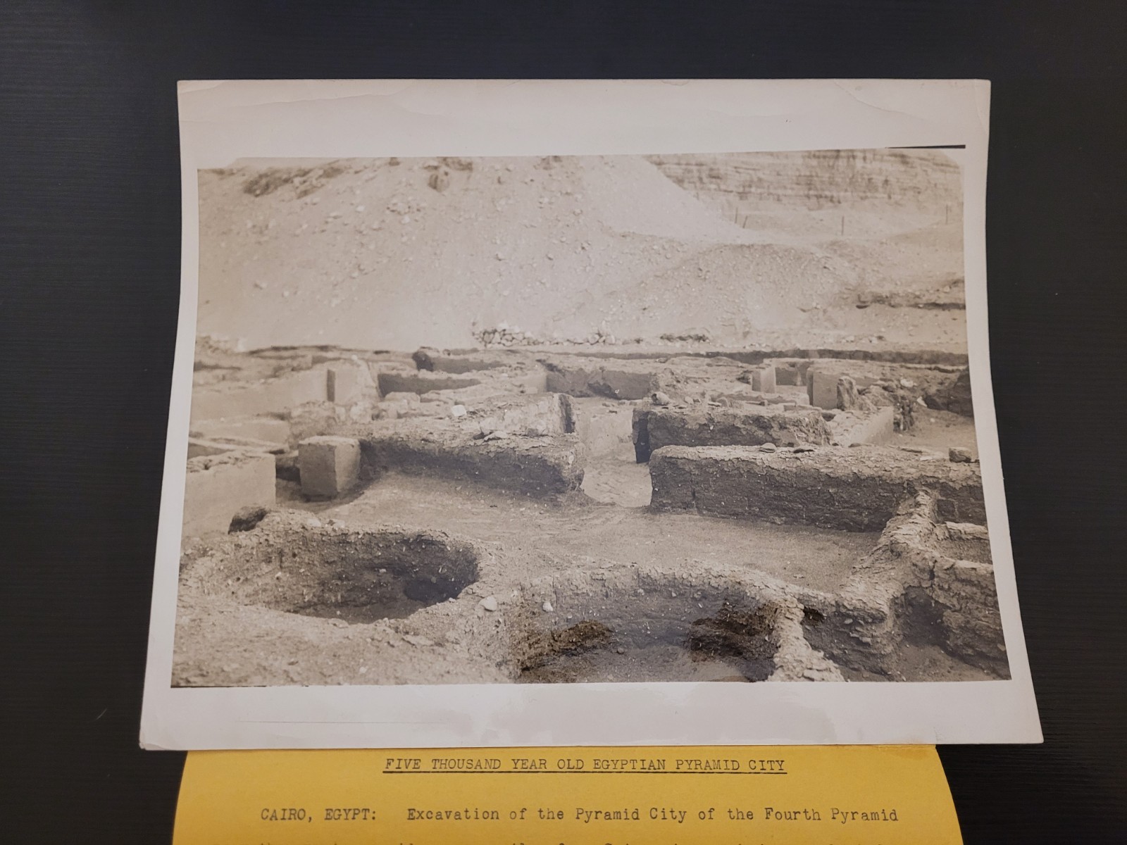
1933 Cairo Egypt Excavation Photo Dr. Selim Hassan Pyramid City Giza Tomb 8x10 For Sale

When you click on links to various merchants on this site and make a purchase, this can result in this site earning a commission. Affiliate programs and affiliations include, but are not limited to, the eBay Partner Network.

1933 Cairo Egypt Excavation Photo Dr. Selim Hassan Pyramid City Giza Tomb 8x10:
$250.00
This original September 15, 1933, silver gelatin press photograph documents a groundbreaking archaeological moment: the excavation of the \"Pyramid City\" (the Lost City of the Pyramids) at Giza. Led by Dr. Selim Hassan, the first native Egyptian Professor of Egyptology at the University of Cairo, this dig uncovered the domestic lives of the builders of the Fourth Dynasty. The image highlights ancient cylindrical grain bins, remarkably similar to those used in 1930s Egyptian villages, located directly across from the tomb of the grain administrator in the Necropolis. This specific find helped archaeologists understand the sophisticated logistics required to sustain the massive workforce that built the Great Pyramids. Transcription of Text Front (Typed Yellow Snipe): \"FIVE THOUSAND YEAR OLD EGYPTIAN PYRAMID CITY CAIRO, EGYPT: Excavation of the Pyramid City of the Fourth Pyramid near the great pyramids, seven miles from Cairo, is now being conducted by the University of Cairo, under direction of Dr. Selim Hassan. Photo shows: In foreground the bases of cylindrical grain bins in the Pyramid City, almost exactly like the grain bins used today in native settlements. Just opposite these bins and across the street, in the Necropolis, is the tomb of the administrator of the grain. Photo Hamilton M. Wright\" Back of Photo (Stamps & Notes): \"HAMILTON M. WRIGHT, \'NEWSPAPER FEATURE NEWS.\' 3003 CHRYSLER BLDG., 405 LEXINGTON AVE. NEW YORK CITY\" \"SEP 15 1933\" (Date Stamp) \"CENTRAL PRESS ASSOCIATION REFERENCE DEPT.\" Handwritten numbers: \"#33F\", \"402\", \"1456\" Biographical Profile Dr. Selim Hassan (1886–1961): A pioneer of Egyptian archaeology, he conducted ten seasons of excavations at Giza between 1929 and 1939, authoring the definitive 16-volume work Excavations at Gîza. Hamilton M. Wright: A prominent New York-based photographer known for capturing iconic 20th-century imagery, operating out of the Chrysler Building.
Details and Keywords Event: Discovery of the Giza Pyramid City Grain Bins. Date: September 15, 1933. Size: 8x10 inches (approx). Keywords: Ancient Egypt, Giza Plateau, Archaeology Press Photo, Fourth Dynasty, Pharaoh Khufu, Egyptology Collectible, 1930s News Photo, Silver Gelatin is the third-largest city in Egypt by area; and sixteenth-largest city in Africa by population. It is the capital of Giza Governorate with a total population of 4,458,135 as of 2023.[2] It is located on the west bank of the Nile opposite central Cairo, and is a part of the Greater Cairo metropolis.[3] Giza lies less than 30 kilometres (20 miles) north of Memphis (Men-nefer, today the village of Mit Rahina), which was the capital city of the unified Egyptian state during the reign of pharaoh Narmer, roughly 3100 BC.Giza is most famous as the location of the Giza Plateau, the site of some of the most impressive ancient monuments in the world, including a complex of ancient Egyptian royal mortuary and sacred structures, among which are the Great Sphinx, the Great Pyramid of Giza, and a number of other large pyramids and temples, and the Grand Egyptian Museum. Giza has always been a focal point in Egypt\'s history due to its location close to Memphis, the ancient pharaonic capital of the Old Kingdom.In 2024, Giza was visited by 14.7 million tourists, becoming the most popular tourist destination in Egypt.[4] Its historic centre is listed by UNESCO as a World Heritage Site.[5] Giza also hosts the headquarters of several Egyptian multinational companies and banks.[6] Rich in ancient Egyptian heritage, hotels, restaurants, and bazaars, Giza is considered an important economic, scientific, and tourism centre of Egypt and Africa. The Giza Zoo, the first zoo built in Africa, is located in Giza. The city also is the home of the association football club Zamalek SC.
Districts and populationThe city of Giza is the capital of the Giza Governorate, and is located near the northeast border of this governorate.
2017 population and administrative divisionsGiza city is a municipal division and capital of Giza governorate with an appointed city head.[7] It comprises nine districts (ahya\', singl. hayy) and five new towns (mudun jadidah) administered by the New Urban Communities Authority (NUCA).The districts/qisms fully subsume to the city head and according to the 2017 census had 4,872,448 residents:[8][9]
District/qism Code 2017 Population
Shamal (North)/ Imbâba 210100 632,599
Agouza, al- 210200 278,479
Duqqî, al- 210300 70,926
Janoub (South)/ Jîza, al- 210400 285,723
Bûlâq al-Dakrûr 210500 960,031
`Umrâniyya, al- 210600 366,066
Ṭâlbiyya, al- 210700 457,667
Ahrâm, al- 210800 659,305
Warrâq, al- 211700 722,083
Shaykh Zâyid, al (new city)[10] 211900 90,699
6 October 1 (new city)[11] 212000 93,012
6 October 2 (new city) 212100 196,373
6 October 3 (new city) 212300 59,485The new towns are mostly administered by the national level New Urban Communities Authority (NUCA), with some public services under the jurisdiction of Giza. They are confusingly named madina (city), however they are not administratively incorporated as such where many are formed of a single district or qism. Ones not in the 2017 census as they were not yet incorporated, or inhabited at that time are: New 6th of October[12]
October Gardens[13]
New Sphinx[14]Permanently inhabited Nile islands: Qorsaya Island (Janoub/Giza district)
Dahab Island (Janoub/Giza district)
Al-Warraq Island (Al-Warraq district)2006 populationThe city\'s population was reported as 2,681,863 in the 2006 national census,[15][16] while the governorate had 6,272,571 at the same census, without specifying what the city is. The former figure corresponds to the sum of nine districts/qisms.
Region (Population) Area
km2
2006
Giza, 9 kisms (contiguous) 2,681,863 98.4
Giza, 10 kisms (not contiguous) 2,822,271 115.7
Giza, 10 kisms + Giza markaz (contiguous) 3,063,777 187
Giza, 10 kisms + Giza, Kerdasa, Ossim markaz (contiguous) – 338.9
Geography and climateGiza\'s most famous landform and archaeological site, the Giza Plateau, holds some major monuments of Egyptian history, and is home to the Great Sphinx. Once thriving with the Nile that flowed right into the Giza Plateau, the pyramids of Giza were built overlooking the ancient Egyptian capital city of Memphis, across the river from modern day Cairo. The Great Pyramid of Giza at one time was advocated (1884) as the location for the Prime Meridian, a reference point used for determining a base longitude.[17]
ClimateGiza experiences a hot desert like arid climate (Köppen: BWh). Its climate is similar to Cairo, owing to its proximity. Windstorms can be frequent across Egypt in spring, bringing Saharan dust into the city during the months of March and April. High temperatures in winter range from 16 to 20 °C (61 to 68 °F), while nighttime lows drop to below 7 °C (45 °F). In summer, the highs are 40 °C (104 °F), and the lows can drop to about 20 °C (68 °F). Rain is infrequent in Giza; snow is extremely rare.Up to August 2013, the highest recorded temperature was 46 °C (115 °F) on 13 June 1965, while the lowest recorded temperature was 2 °C (36 °F) on 8 January 1966.[18]
Climate data for Giza
Month Jan Feb Mar Apr May Jun Jul Aug Sep Oct Nov Dec Year
Record high °C (°F) 28
(82) 30
(86) 36
(97) 41
(106) 43
(109) 46
(115) 41
(106) 43
(109) 39
(102) 40
(104) 36
(97) 30
(86) 46
(115)
Mean daily maximum °C (°F) 19.3
(66.7) 20.9
(69.6) 24.2
(75.6) 28.4
(83.1) 32.0
(89.6) 34.9
(94.8) 34.5
(94.1) 34.4
(93.9) 32.4
(90.3) 30.2
(86.4) 25.4
(77.7) 21.1
(70.0) 28.1
(82.6)
Daily mean °C (°F) 13.0
(55.4) 14.0
(57.2) 17.2
(63.0) 20.5
(68.9) 24.0
(75.2) 27.1
(80.8) 27.5
(81.5) 27.5
(81.5) 25.6
(78.1) 23.5
(74.3) 19.2
(66.6) 15.0
(59.0) 21.2
(70.1)
Mean daily minimum °C (°F) 6.8
(44.2) 7.2
(45.0) 10.3
(50.5) 12.7
(54.9) 16.1
(61.0) 19.3
(66.7) 20.6
(69.1) 20.7
(69.3) 18.9
(66.0) 16.8
(62.2) 13.0
(55.4) 8.9
(48.0) 14.3
(57.7)
Record low °C (°F) 2
(36) 4
(39) 5
(41) 8
(46) 11
(52) 16
(61) 17
(63) 17
(63) 16
(61) 11
(52) 4
(39) 4
(39) 2
(36)
Average precipitation mm (inches) 4
(0.2) 3
(0.1) 2
(0.1) 1
(0.0) 0
(0) 0
(0) 0
(0) 0
(0) 0
(0) 0
(0) 3
(0.1) 4
(0.2) 17
(0.7)
Source 1: Climate-Data.org[19]
Source 2: Voodoo Skies[18] for record temperatures
History
Ancient era
The Giza pyramid complex
The Giza pyramid complexThe area in what is now Giza served as the necropolis of several pharaohs who ruled ancient Egypt, during the second millennium BC. Three of these tombs, in the form of giant pyramids, are what is now the famed Giza pyramid complex, featuring the Great Pyramid of Giza, the Great Sphinx of Giza and the Grand Egyptian Museum.
Classical to medieval era
Giza and the bridge from Roda Island in c. 1800 Description de l\'ÉgypteAs ancient Egypt passed under several conquests under the Persians, Greeks, Romans and Byzantines, so did the area in what is now Giza. A Byzantine village named Phylake (Greek: Φυλακή) or Terso (Coptic: ϯⲣⲥⲱ, meaning \"the fortress\", now Tersa) was located south of Giza and should not be confused with it.[20][21][22]Egyptians called the area Tipersis (Bohairic Coptic: ϯⲡⲉⲣⲥⲓⲥ[b] and Sahidic Coptic: ⲧⲡⲉⲣⲥⲓⲥ ⲛ̀ⲃⲁⲃⲩⲗⲱⲛ, lit. \'the Persian (fortress) of Babylon\').[23][24][25] Eutychius gives a legend about the city\'s name and its foundation by Artaxerxes Ochus or Hūš (Arabic: خوش),[26] and Abu Salih says it was found by him at the same time as Qasr ash-Sham,[27] but as older evidence is missing, it is perhaps most likely to have been founded during the Sasanian conquest of Egypt in the early 7th century.[28]As Muslims of the fledgling Islamic caliphate went on with their conquest of Egypt from the Byzantine Empire beginning in 639 AD, three years after their victory at the battle of Yarmouk in 636 AD, they conquered all of the land by the time they captured the city of Alexandria in 641 AD. A year later in 642 AD (year 21 in Islamic calendar), they founded the city of Giza. The exact etymology of its name is unknown. Al-Maqrizi suggested an irregular Arameo-Arabic root meaning \"edge, side\" to be the source. Everett-Heath suggested Ancient Egyptian: r-gs-ḥr \"on the side of the height (pyramid)\". Peust also suggests a Persian etymology of the word from Middle Persian: 𐭣𐭦, romanized: diz, lit. \'fortress, castle\', which Persians could have given to the pyramids or a fortress they found in the area.[29]
AdministrationThe city is managed by an appointed City Head (President of the City) and the Governor of Giza, who is appointed by the President of Egypt. The current Governor of Giza is Major General Adel El-Ghadban (taking office in 2024).The administration is divided into Executive Council, which is the appointed body that implements government policies and the Local People’s Council, which is historically an elected body meant for local oversight (though its functions are largely centralized).[30]Giza City is divided into 9 urban districts, which are the primary units for day-to-day governance and public services: North Giza (Imbaba)
Agouza
Dokki
South Giza
Bulaq el-Dakrur
El-Omrania
El-Talbiya
El-Haram (The Pyramids district)
El-WarraqMany regional and national government entities have offices within Giza to serve the Greater Cairo area such as; the Giza Governorate Headquarters, Health Affairs Directorate, Giza Elementary Court, and Foreign Ministry Legalization Office.
EconomyIndustries in Giza include film making, the city is considered a hub of Egyptian studios such as Studio Misr and El-Ahram Studio, and several movie production companies have their headquarters in Giza. [31][32][33]A main source of income in Giza is tourism as a home to many historical sites including the Great Pyramid and Pyramid of Djoser and the Grand Egyptian Museum.Chemicals is an important industry in Giza, Giza Paints & Chemical Industries was established in 1984.[34]Giza has many luxury apartment buildings along the Nile, making it a popular place to live.
Tourism
Main article: Tourism in Egypt
Cityscape of the banks of the Nile
Cityscape of the banks of the NileA vital revenue source, with millions of visitors coming to see the Giza Pyramids and ancient artifacts. Tourism revenues reached $15.3 billion nationally in 2024.
Giza Plateau
Main article: Giza Plateau
Aerial view of Giza pyramid complexGiza Plateau has several remains from the 26th century BC such as temples and monuments to Egyptian Pharaohs including the Great Sphinx, and the Great Pyramids of Giza.[35] The Giza Plateau also includes Saqqara, the ancient burial ground which served as the necropolis for the Ancient Egyptian capital of Memphis. It features numerous pyramids, including the world\'s oldest standing step pyramid, as well as a number of mastabas.[36]
Pharaonic Village
Main article: Pharaonic VillageThe Jacob Island was transformed into a highly accurate replica of ancient Egyptian life, in 1974. The village contains the Mummification Museum, Replica of Tutankhamun’s Tomb and Village souvenirs.[37] Also from modern era, the village includes museums for former Presidents; Gamal Abdel Nasser Museum and Anwar Sadat.[38][39]
Giza Zoo
Main article: Giza Zoo
View of the lake of Giza ZooThe Giza Zoo was established on March 1, 1891, it holds the distinction of being Africa\'s first zoo and the world\'s third oldest zoological garden.[40] Located on approximately 80 acres (32 hectares), the zoo was originally designed as a botanical garden and features several historical architectural elements.[41]
Historical featuresThe zoo contains several notable architectural and cultural landmarks: A suspension bridge designed by Gustave Eiffel (1875-1879), considered the world\'s first elevated zoo viewing platform[42]
The Japanese Kiosk, constructed in 1924 during King Fuad\'s reign
Original gates from the Khedive\'s Palace and Haramlik Palace
Roads paved with black stone imported from Trieste
Mosaic-decorated footpaths
A marble island known as Tea IslandAnimal collectionThe zoo houses approximately 4,000 animals representing over 175 species,[43] including: Large mammals: Lions, tigers, giraffes, rhinoceros, hippopotamuses
Primates: Various monkey and ape species
Birds: Native and exotic species including flamingos and rare birds
Reptiles: Including Egyptian cobras and Nile crocodilesRecent developmentsIn 2023, the Egyptian government announced plans to expand the number of animal species from 71 to 186.[44] The renovation project includes: Creation of specialized zones: Asia, Africa, America, Family Zone, Safari Trips
Establishment of educational centers
Preservation of historical landmarks
Improvement of animal enclosuresOrman Garden
Main article: Orman Garden
Orman GardenThe garden covers about 28 acres. Today, the garden contains a rock garden, a rose garden, cactus gardens, and probably the most notable feature, the lotus pond. small botanical museum attached to the garden shelters herbaria dating from the Khedive Ismail and furniture from the king Farouk.[45]
InfrastructureGiza has seen many changes over time. Changes in infrastructure during thousands of years of Egyptian history.[46] Giza is a thriving centre of Egyptian culture and is quite heavily populated, with many facilities and buildings in the current area. Giza saw much attention in particular to its vast amount of ancient Egyptian heritage on the Giza Plateau, and has astonished millions of visitors and tourists over the years.
Education
Cairo UniversityGiza\'s learning institutions include Cairo University, which was moved to Giza in 1924. The city is a hub of education and educational services not only for Egypt but also for the entire Mediterranean Region. Giza has numerous schools, kindergartens, and institutes of higher learning.MSA University, founded in 1996, the university is accredited by the Egyptian and British ministry of education and graduate students can study in Britain without any equivalence.[47] Institute of Aviation Engineering and Technology, is an Engineering private faculty.[48] It is a part of the Ministry Of Civil Aviation in Egypt, and the Ministry Of Higher Education under the academic supervision of Faculty of Engineering, Cairo University.[49]Also the Higher Institute Of Cinema, also known as the Cairo Higher Institute of Cinema, is a film school. It is one of several institutes making up the Egyptian Academy of Arts. Founded in 1959, it is the oldest film school in the Middle East and Africa.[50][51]The Cairo Japanese School, a Japanese international school, is in Giza.[52] Also the Deutsche Evangelische Oberschule, a German international school, is located in Dokki in Giza.[53] Previously the Pakistan International School of Cairo had its campus in Giza.[54]
HealthcareHealthcare services are widely available in Giza, ranging from private to public facilities, including internationally accredited hospitals, clinics, and numerous local pharmacies.[55][56] The Egyptian government has prioritized improving healthcare through investment in the development of public hospitals.[57][58] Private hospitals and medical centers in Giza include; ABC Hospital, AL Kawkab Hospital, Sphinx Specialized Hospital, Gannah Hospital, Al Assema Hospital, El Safa Hospital, El Salam Hospital El Haram, Giza Specialized Hospital, and El Shorouk article: Sphinx International Airport
Sphinx International Airport terminal 1Access to the city of Giza, which has its own governorate adjacent to the Governorate of Cairo, is dependent on the Cairo International Airport. It is an international airport located on the Cairo–Alexandria desert road, 45 kilometers from Giza. The Sphinx International Airport was opened in 2018 as an alternative to the already congested Cairo International Airport, but also to improve accessibility to the Giza necropolis as well as to the Grand Egyptian Museum.[61][62] The airport was established to relieve the pressure on Cairo International Airport and also serving the cities of Sheikh Zayed and 6th of October areas and some nearby governorates such as Beni Suef and Fayoum.[63]
TrainBashteel Railway Station, also called Upper Egypt Railway Station, is a major railway station, and the main railway station in Giza. It is located in Bashteel district. It is intended to serve as a new major railway hub in Greater Cairo and to relieve congestion at Ramses Station.[64]
Metro
Main article: Cairo Metro Line 3
The Cairo Metro (line 3)Giza shares with Cairo a subway system, officially called the \"Metro (مترو)\", a fast and efficient way of getting around. An extensive road network connects Giza with 6th of October City, Cairo and other cities. There are flyovers and bridges such as the 15th. Traffic in Giza is known to be overwhelming and overcrowded.
RoadsAn extensive road network connects Giza with other Egyptian cities. There is a Ring Road that surrounds the outskirts of the Cairo metropolitan area. There are flyovers, tunnels and bridges, such as the Saft El Laban axis that, when the traffic is not heavy, allow fast means of transportation from one side of the city to the other. Giza traffic is known to be overwhelming and overcrowded.Other means of transport include: Cairo Taxi
Uber (available in Cairo and Giza since 2015)[65]
Careem (available in Cairo and Giza since 2015)[66]
Swvl (available in Cairo and Giza since 2017)
Water taxis (motorized feluccas) available for transport to nearby places along the Nile River.Bus system
Main article: Cairo Bus Rapid TransitThere are two types of buses in Giza, the minibuses and public buses. Bus lines are spread all over the Greater Cairo area, and are considered the main mean of transport for many Cairenes.[67][68]
Culture
Main article: Cultural tourism in Egypt
Museums
Grand Egyptian Museum
Main article: Grand Egyptian Museum
Main entrance of the GEMAll of the collection of the Museum of Egyptian Civilization, including the Tutankhamun collection, are slated to be moved to the new Grand Egyptian Museum, under construction in Giza, and was due to open by the end of 2020.[69][70] Dedicated to Ancient Egypt and its culture, society, and artifacts, the GEM is the largest museum in the world for a single civilization. The museum also includes a conservation center, a conference center, and various dining and shopping areas.[71][72]
Egyptian Agricultural Museum
Main article: Agricultural Museum, EgyptThe Egyptian Agricultural Museum is a museum complex built primarily to showcase the history of agriculture in Egypt throughout its various eras. Located in the Dokki district of Giza, the museum was initially named the \"Fouad I Agricultural Museum,\" it was housed in the palace of Princess Fatima Ismail.[73] The museum later expanded to include several other buildings and museums, encompassing eight museums in one, covering an area of over 30 acres (approximately 175,000 square meters), interspersed with green spaces and gardens. It is considered one of the first and largest agricultural museums in the world and houses 1,451 registered artifacts, in addition to other collections.[74][75]
Mohamed Mahmoud Khalil Museum
Main article: Mohamed Mahmoud Khalil Museum
Museum facadeThe Mohamed Mahmoud Khalil Museum and Palace is an Egyptian museum located in the Giza district of Cairo. It was founded by Mohamed Mahmoud Khalil. The palace was first opened as a museum in 1962, then moved to the Prince Amr Ibrahim Palace in Zamalek in 1971, before reopening in Zamalek in 1979.[76][77][78]
Taha Hussein Museum
Main article: Taha Hussein MuseumThe Taha Hussein Museum is Taha Hussein\'s villa, also known as \"Ramtan,\" which the Egyptian Ministry of Culture converted into a museum to commemorate the Dean of Arabic Literature. The museum villa consists of two floors and a library.[79]
Mohamed Nagy Museum
Main article: Mohamed Nagy MuseumThe Mohamed Nagy Museum is a historical photography museum located at Mahmoud El Gendy Street near the Giza Plateau, in the Haram district of Giza, in southwest Greater Cairo. It was founded in 1952 by Mohamed Nagy as his studio, as he was a pioneer of modern Egyptian photography in modern Egypt.[6][7] After his death, he converted the studio into a museum, which was officially opened by the Egyptian Minister of Culture, Tharwat Okasha, on July 13, 1968. The museum was renovated in 1991.[4][5]
Imhotep Museum
Main article: Imhotep Museum
Museum\'s entranceThe Imhotep Museum is an archaeological museum located at the foot of the Saqqara necropolis complex, near Memphis in Lower Egypt.[80] The museum was established to honor and commemorate the ancient Egyptian architect Imhotep, the builder of King Pyramid of Djoser, as the first to construct a pyramid and the first to use stone in the construction of massive buildings.[81][82] The museum consists of several halls housing more than 500 rare artifacts unearthed from the Saqqara archaeological site. The museum\'s exhibits include a model of King Djoser\'s funerary complex, and one of the halls is designed as a complete tomb displaying a mummy, a wooden coffin, and a number of pottery and alabaster vessels. The museum also houses the library of the Egyptologist Jean-Philippe Lauer.[83][84]
MusicMusic in Giza is characterized by high-profile international concerts at the Pyramids, historic residency shows, and a vibrant local nightlife scene in the surrounding district. The Pyramids Sound and Light Show is a nightly performance where the Great Sphinx narrates the history of ancient Egypt, accompanied by dramatic music and laser projections.[85][86]The city of Giza host several live music venues. The city also has a long history of hosting legendary acts, specifically at the Giza Plateau, such as Grateful Dead played a series of concerts in 1978 during a lunar eclipse.[87][88] And Jean-Michel Jarre, held on the massive Twelve Dreams of the Sun millennium concert on New Year\'s Eve 1999.[89][90]
Holidays and festivalsGiza Governorate\'s National Day is celebrated on March 31st each year, commemorating the struggle of Giza\'s people against the British occupation, specifically the Battle of Nazlet El-Shobak in Badrasheen in 1919, where the locals confronted a train of occupation soldiers and sacrificed martyrs for their country.[91] Cultural celebrations, events, and project inaugurations are held to honor this anniversary. The city also celebrates a mix of Islamic, Coptic Christian, and national holidays, featuring vibrant festivals like the Eid holidays such as Eid al-Fitr, Eid al-Adha, religious observances like Coptic Christmas on January 7th and Mawlid al-Nabi, and national days such as Revolution Day on January 25th and Armed Forces Day on October 6th, alongside cultural events like Sham El-Nessim and unique spectacles offering diverse cultural experiences year-round. Ramadan is the holy month of fasting, observed with special meals and community focus.[92][93]
Painting and sculpture
Egypt\'s Renaissance Statue is a living symbol of modern Egyptian art.Giza is a destination for both ancient and contemporary art, housing monumental sculptures and dedicated painting museums, located primarily on the Giza Plateau. The Great Sphinx of Giza is the oldest known monumental sculpture in Egypt, this limestone statue depicts a reclining sphinx with the head of a Pharaoh. Evidence suggests it was once painted in bright colors.[94][95]The Egypt’s Renaissance Statue, located near the Cairo University bridge, the 1928 sculpture by Mahmoud Mokhtar is a key symbol of modern Egyptian identity, blending Egyptian style with 20th-century nationalism. Giza has yielded world-famous works like the Bust of Prince Ankhhaf and the Pair Statue of King Menkaure and Queen, which are celebrated for their realistic portraiture.[96][97] Modern Giza hosts large-scale international art events that place contemporary sculpture in dialogue with the pyramids.[98][99]The Grand Egyptian Museum (GEM) is a landmark institution which showcases thousands of artifacts, including the world’s largest collection of Tutankhamun’s treasures and numerous monumental statues.[100] Other specialized museums and galleries Ramses Wissa Wassef Art Center and the Museum of Nagy.[101][102]
MediaGiza is a global center for media production and is currently expanding its infrastructure with massive 2025 projects. The Egyptian Media Production City (EMPC) is located in 6th of October City, a satellite city in the Giza Governorate, the EMPC is the primary media hub for Egypt.[103] It covers approximately 35 million square meters and features 114 studios equipped for cinematography, TV, and video production.[104][105]The Media Public Free Zone was established to attract investment, this zone offers specialized infrastructure, including satellite broadcasting stations and technical service centers for media projects.[106] Besides the United for Media Services, the leading media production companies in Giza include Birdmilk, Big Move Agency, Vision Egypt, and Sway Media.[107]Several newspapers are based in Giza, such as the Daily News Egypt, the country\'s only independent English-language daily newspaper, with its headquarters are located in Dokki. Also the El Watan News, which is a comprehensive daily online portal and printed newspaper with its address in Dokki as well.[108] Also the El Wafd, associated with Egyptian Wafd Party. The Egypt Today Magazine and media production company is also located in Giza.[109]In November 2025, Giza was officially listed in the UNESCO Creative Cities Network in recognition of its deep-rooted legacy in the film and arts industry.[110]
SportThe city is home to the 20th most successful sports club in Africa, the Zamalek Sporting Club, an Egyptian giant, located in the Meet Okba neighborhood near the Mohandiseen district in Giza.[111] Beside the Zamalek Sporting Club, there are other clubs like El Tersana SC and Egyptian Shooting Club which is one of the elite clubs in Egypt, located in Dokki neighborhood.[112]
International relations
Twin towns – sister cities
See also: List of twin towns and sister cities in EgyptGiza is twinned with: Turkey Istanbul, Turkey[113]
United States Los Angeles, United States[114]Notable people Amr Abou El Seoud (born 1968), bank CEO
Yehia Chahine, actor
Ahmed El-Ahmar, handball player
Abdel Halim Ali, football player
Nora Armani, actor and filmmaker of Armenian descentSee also flagEgypt portal List of cities and towns in Egypt
List of ancient Egyptian sites
List of megalithic sitesCairo[b] is the capital and largest city of Egypt and the Cairo Governorate. It is home to more than 10.5 million people.[5] It is also part of the largest urban agglomeration in Africa, the Arab world, and the Middle East. The Greater Cairo metropolitan area is one of the largest in the world by population with over 22 million people.[3] Areas of what would become Cairo were inhabited from pre-dynastic and early-dynastic ancient Egypt c. 6000 years ago, as the Giza pyramid complex and the ancient cities of Memphis and Heliopolis are today within the city.Located near the Nile Delta, the predecessor city was Fustat following Babylon.[6][7] Subsequently, Cairo was founded in 969.[8] It later superseded Fustat as the main urban centre during the Ayyuoffer and Mamluk periods (12th–16th centuries).[9] Cairo has since become a longstanding centre of political and cultural life, and is titled \"the city of a thousand minarets\" for its preponderance of Islamic architecture. Cairo\'s historic center was awarded World Heritage Site status in 1979.[10] The city is considered a regional center of finance and commerce, academics and the arts, and is home to Cairo Symphony Orchestra and the Cairo Opera House,[11] while the Academy of Arts provides visual arts education.[12][13]Cairo is home to Egypt\'s oldest university, Al-Azhar University, one of the oldest universities in the world,[14] as well as the oldest and largest film and music industry in Africa and the Arab world.[15] Many international media, businesses, and organizations have regional headquarters in Cairo, such as the headquarters of the Arab League, the regional offices of the World Health Organization, Food and Agriculture Organization, International Civil Aviation Organization, United Nations Development Programme, African Space Agency, and also the headquarters of FIBA Africa.[16][17][18]Cairo is a key global city, like many other megacities, suffers from high levels of pollution and traffic.[19][20] The Cairo Metro, opened in 1987, is the oldest metro system in Africa,[21] and ranks amongst the fifteen busiest in the world,[22] with over 1 billion[23] annual passenger rides. The economy of Cairo was ranked first in the Middle East in 2005 on Foreign Policy\'s Global Cities Index,[24][25] and first in Africa in 2025 according to International Monetary Fund,[26][27] and continues to be a major destination for foreign direct investment (FDI) due to its massive consumer market and strategic location.[28][29][30]
EtymologyThe name of Cairo is derived from the Arabic al-Qāhirah (القاهرة), meaning \'the Vanquisher\' or \'the Conqueror\', given by the Fatimid Caliph al-Mu\'izz following the establishment of the city as the capital of the Fatimid dynasty. Its full, formal name was al-Qāhirah al-Mu\'izziyyah (القاهرة المعزيّة), meaning \'the Vanquisher of al-Mu\'izz\'.[31] It is also supposedly due to the fact that the planet Mars, known in Arabic by names such as an-Najm al-Qāhir (النجم القاهر, \'the Conquering Star\'), was rising at the time of the city\'s founding.[32]Egyptians often refer to Cairo as Maṣr (IPA: [mɑsˤɾ]; مَصر), the Egyptian Arabic name for Egypt itself, emphasising the city\'s importance for the country.[33][34]There are a number of Coptic names for the city. Tikešrōmi (Coptic: Ϯⲕⲉϣⲣⲱⲙⲓ Late Coptic: [dikɑʃˈɾoːmi]) is attested in the 1211 text The Martyrdom of John of Phanijoit and is either a calque meaning \'man breaker\' (Ϯ-, \'the\', ⲕⲁϣ-, \'to break\', and ⲣⲱⲙⲓ, \'man\'), akin to Arabic al-Qāhirah, or a derivation from Arabic قَصْر الرُوم (qaṣr ar-rūm, \"the Roman castle\"), another name of Babylon Fortress in Old Cairo.[35] The Arabic name is also calqued as ⲧⲡⲟⲗⲓⲥ ϯⲣⲉϥϭⲣⲟ, \"the victor city\" in the Coptic antiphonary.[36]The form Khairon (Coptic: ⲭⲁⲓⲣⲟⲛ) is attested in the modern Coptic text Ⲡⲓⲫⲓⲣⲓ ⲛ̀ⲧⲉ ϯⲁⲅⲓⲁ ⲙ̀ⲙⲏⲓ Ⲃⲉⲣⲏⲛⲁ (The Tale of Saint Verina).[37][better source needed] Lioui (Ⲗⲓⲟⲩⲓ Late Coptic: [lɪˈjuːj]) or Elioui (Ⲉⲗⲓⲟⲩⲓ Late Coptic: [ælˈjuːj]) is another name which is descended from the Greek name of Heliopolis (Ήλιούπολις).[35] Some argue that Mistram (Ⲙⲓⲥⲧⲣⲁⲙ Late Coptic: [ˈmɪstəɾɑm]) or Nistram (Ⲛⲓⲥⲧⲣⲁⲙ Late Coptic: [ˈnɪstəɾɑm]) is another Coptic name for Cairo, although others think that it is rather a name for the Abbasid province capital al-Askar.[38] Ⲕⲁϩⲓⲣⲏ (Kahi•ree) is a popular modern rendering of an Arabic name (others being Ⲕⲁⲓⲣⲟⲛ [Kairon] and Ⲕⲁϩⲓⲣⲁ [Kahira]) which is modern folk etymology meaning \'land of sun\'. Some argue that it was the name of an Egyptian settlement upon which Cairo was built, but it is rather doubtful as this name is not attested in any Hieroglyphic or Demotic source, although some researchers, like Paul Casanova, view it as a legitimate theory.[35] Cairo is also referred to as Ⲭⲏⲙⲓ (Late Coptic: [ˈkɪmi]) or Ⲅⲩⲡⲧⲟⲥ (Late Coptic: [ˈɡɪpdos]), which means Egypt in Coptic, the same way it is referred to in Egyptian Arabic.[38]Sometimes the city is informally referred to as Cairo by people from Alexandria (IPA: [ˈkæjɾo]; Egyptian Arabic: كايرو).[39]
History
See also: History of Egypt
For a chronological guide, see Timeline of Cairo.
Ancient settlements
The remains of a circular Roman tower at Babylon Fortress, late 3rd century, in Old CairoThe area around present-day Cairo had long been a focal point of Ancient Egypt due to its strategic location at the junction of the Nile Valley and the Nile Delta regions (roughly Upper Egypt and Lower Egypt), which also placed it at the crossing of major routes between North Africa and the Levant.[40][41] Memphis, the capital of Egypt during the Old Kingdom and a major city up until the Ptolemaic period, was located a short distance south west of present-day Cairo.[42] Heliopolis, another important city and major religious center, was located in what are now the modern districts of Matariya and Ain Shams in northeastern Cairo.[42][43] It was largely destroyed by the Persian invasions in 525 BC and 343 BC and partly abandoned by the late first century BC.[40]However, the origins of modern Cairo are generally traced back to a series of settlements in the first millennium AD. Around the turn of the fourth century,[44] as Memphis was continuing to decline in importance,[45] the Romans established a large fortress along the east bank of the Nile. The trading post of Babylon, first mentioned in 50 BC,[46] became a fortress, built by the Roman emperor Diocletian (r. 285–305) at the entrance of a canal connecting the Nile to the Red Sea that was created earlier by Emperor Trajan (r. 98–117).[c][47] Further north of the fortress, near the present-day district of al-Azbakiya, was a port and fortified outpost known as Tendunyas (Coptic: ϯⲁⲛⲧⲱⲛⲓⲁⲥ)[48] or Umm Dunayn.[49][50][51] While no structures older than the 7th century have been preserved in the area aside from the Roman fortifications, historical evidence suggests that a sizeable city existed. The city was important enough that its bishop, Cyrus, participated in the Second Council of Ephesus in 449.[52]The Byzantine-Sassanian War between 602 and 628 caused great hardship and likely caused much of the urban population to leave for the countryside, leaving the settlement partly deserted.[50] The site today remains at the nucleus of the Coptic Orthodox community, which separated from the Roman and Byzantine churches in the late 4th century. Cairo\'s oldest extant churches, such as the Church of Saint Barbara and the Church of Saints Sergius and Bacchus (from the late 7th or early 8th century), are located inside the fortress walls in what is now known as Old Cairo or Coptic Cairo.[53]
Fustat and other early Islamic settlements
Further information: Egypt in the Middle Ages
A man on a donkey walks past a palm tree, with a mosque and market behind Mohamed kamal
Excavated ruins of Fustat, 2004The Muslim conquest of Byzantine Egypt was led by Amr ibn al-As from 639 to 642. Babylon Fortress was besieged in September 640 and fell in April 641. In 641 or early 642, after the surrender of Alexandria, the Egyptian capital at the time, he founded a new settlement next to Babylon Fortress.[54][55] The city, known as Fustat (Arabic: الفسطاط, romanised: al-Fusṭāṭ, lit. \'the tent\'), served as a garrison town and as the new administrative capital of Egypt. Historians such as Janet Abu-Lughod and André Raymond trace the genesis of present-day Cairo to the foundation of Fustat.[56][57]The choice of founding a new settlement at this inland location, instead of using the existing capital of Alexandria on the Mediterranean coast, may have been due to the new conquerors\' strategic priorities. One of the first projects of the new Muslim administration was to clear and re-open Trajan\'s ancient canal in order to ship grain more directly from Egypt to Medina, the capital of the caliphate in Arabia.[58][59][60][61] Ibn al-As also founded a mosque for the city at the same time, now known as the Mosque of Amr Ibn al-As, the oldest mosque in Egypt and Africa (although the current structure dates from later expansions).[41][62][63][64]
A man on a donkey walks past a palm tree, with a mosque and market behind Mohamed kamal
The Nilometer in Cairo, built by the order of the Abbasid caliph al-Mutawakkil (r. 847–861)In 750, following the overthrow of the Umayyad Caliphate by the Abbasids, the new rulers created their own settlement to the northeast of Fustat which became the new provincial capital. This was known as al-Askar (Arabic: العسكر, lit. \'the camp\') as it was laid out like a military camp. A governor\'s residence and a new mosque were also added, with the latter completed in 786.[65] The Red Sea canal re-excavated in the 7th century was closed by the Abbasid Caliph al-Mansur (r. 754–775),[66] but a part of the canal, known as the Khalij, continued to be a major feature of Cairo\'s geography and of its water supply until the 19th century.[67][41] In 861, on the orders of the Abbasid Caliph al-Mutawakkil, a Nilometer was built on Roda Island near Fustat. Although it was repaired and given a new roof in later centuries, its basic structure is still preserved today, making it the oldest preserved Islamic-era structure in Cairo today.[68][69]
The Mosque of Ibn Tulun, built by Ahmad Ibn Tulun in 876–879 ADIn 868, a commander of Turkic origin named Bakbak was sent to Egypt by the Abbasid Caliph al-Mu\'taz to restore order after a rebellion in the country. He was accompanied by his stepson, Ahmad ibn Tulun, who became effective governor of Egypt. Over time, Ibn Tulun gained an army and accumulated influence and wealth, allowing him to become the de facto independent ruler of both Egypt and Syria by 878.[70][71][72] In 870, he used his growing wealth to found a new administrative capital, al-Qata\'i (Arabic: القطائـع, lit. \'the allotments\'), to the northeast of Fustat and of al-Askar.[72][73]The new city included a palace known as the Dar al-Imara, a parade ground known as al-Maydan, a bimaristan (hospital), and an aqueduct to supply water. Between 876 and 879 Ibn Tulun built a great mosque, now known as the Mosque of Ibn Tulun, at the center of the city, next to the palace.[71][73] After his death in 884, Ibn Tulun was succeeded by his son and his descendants who continued a short-lived dynasty, the Tulunids. In 905, the Abbasids sent general Muhammad Sulayman al-Katib to re-assert direct control over the country. Tulunid rule was ended and al-Qatta\'i was razed to the ground, except for the mosque which remains standing today.[74][75]
Foundation and expansion of Cairo under the Fatimids
The Al-Azhar Mosque, built in 970–972 in the wake of the establishment of Cairo as the capital of the Fatimid CaliphateIn 969, the Fatimid Caliphate conquered Egypt after ruling from Ifriqiya. The Fatimid Caliph al-Mu\'izz li-Din Allah instructed his courtier and general Jawhar al-Saqili to establish a new fortified city northeast of Fustat and of former al-Qata\'i. It took four years to build the city, initially known as al-Manṣūriyyah,[76] which was to serve as the new capital of the caliphate.[77] During that time, the construction of the al-Azhar Mosque was commissioned by order of the caliph, which developed into the third-oldest university in the world. Cairo would eventually become a centre of learning, with the library of Cairo containing hundreds of thousands of books.[78] When Caliph al-Mu\'izz arrived from the old Fatimid capital of Mahdia in Tunisia in 973, he gave the city its present name, Qāhirat al-Mu\'izz (\"The Vanquisher of al-Mu\'izz\"),[76] from which the name \"Cairo\" (al-Qāhira) originates. The caliphs lived in a vast and lavish palace complex that occupied the heart of the city. Cairo remained a relatively exclusive royal city for most of this era, but during the tenure of Badr al-Gamali as vizier (1073–1094) the restrictions were loosened for the first time and richer families from Fustat were allowed to move into the city.[79] Between 1087 and 1092 Badr al-Gamali also rebuilt the city walls in stone and constructed the city gates of Bab al-Futuh, Bab al-Nasr, and Bab Zuweila that still stand today.[80]During the Fatimid period Fustat reached its apogee in size and prosperity, acting as a center of craftsmanship and international trade and as the area\'s main port on the Nile.[81] Historical sources report that multi-story communal residences existed in the city, particularly in its center, which were typically inhabited by middle and lower-class residents. Some of these were as high as seven stories and could house some 200 to 350 people.[82] They may have been similar to Roman insulae and may have been the prototypes for the rental apartment complexes which became common in the later Mamluk and Ottoman periods.[82] However, in 1168 the Fatimid vizier Shawar set fire to the unfortified Fustat to prevent its potential capture by Amalric, the Crusader king of Jerusalem. While the fire did not destroy the city and it continued to exist afterward, it did mark the beginning of its decline. Over the following centuries it was Cairo, the former palace-city, that became the new economic center and attracted migration from Fustat.[83][84]
A multi-domed mosque dominates the walled Citadel, with ruined tombs and a lone minaret in front.
The Cairo Citadel, seen above in the 19th century, commissioned in 1176While the Crusaders did not capture the city in 1168, a continuing power struggle between Shawar, King Amalric, and the Zengid general Shirkuh led to the downfall of the Fatimid establishment.[85] In 1169, Shirkuh\'s nephew Saladin was appointed as the new vizier of Egypt by the Fatimids and two years later he seized power from the family of the last Fatimid caliph, al-\'Āḍid.[86] As the first Sultan of Egypt, Saladin established the Ayyuoffer dynasty, based in Cairo, and aligned Egypt with the Sunni Abbasids, who were based in Baghdad.[87] In 1176, Saladin began construction on the Cairo Citadel, which was to serve as the seat of the Egyptian government until the mid-19th century. The construction of the Citadel definitively ended Fatimid-built Cairo\'s status as an exclusive palace-city and opened it up to common Egyptians and to foreign merchants, spurring its commercial development.[88] Along with the Citadel, Saladin also began the construction of a new 20-kilometre-long wall that would protect both Cairo and Fustat on their eastern side and connect them with the new Citadel. These construction projects continued beyond Saladin\'s lifetime and were completed under his Ayyuoffer successors.[89]
Further expansion and decline under the Ayyuoffers and Mamluks
The Mausoleum-Madrasa-Hospital complex of Sultan Qalawun, built in 1284–1285 in the center of Cairo, over the remains of a Fatimid palaceIn 1250, during the Seventh Crusade, the Ayyuoffer dynasty had a crisis with the death of al-Salih and power transitioned instead to the Mamluks, partly with the help of al-Salih\'s wife, Shajar ad-Durr, who ruled for a brief period around this time.[90][91] Mamluks were soldiers who were purchased as young slaves and raised to serve in the sultan\'s army. Between 1250 and 1517 the throne of the Mamluk Sultanate passed from one mamluk to another in a system of succession that was generally non-hereditary, but also frequently violent and chaotic.[92][93] The Mamluk Empire nonetheless became a major power in the region and was responsible for repelling the advance of the Mongols (most famously at the Battle of Ain Jalut in 1260) and for eliminating the last Crusader states in the Levant.[94]Despite their military character, the Mamluks were also prolific builders and left a rich architectural legacy throughout Cairo.[95] Continuing a practice started by the Ayyuoffers, much of the land occupied by former Fatimid palaces was sold and replaced by newer buildings, becoming a prestigious site for the construction of Mamluk religious and funerary complexes.[96] Construction projects initiated by the Mamluks pushed the city outward while also bringing new infrastructure to the centre of the city.[97] Meanwhile, Cairo flourished as a centre of Islamic scholarship and a crossroads on the spice trade route among the civilisations in Afro-Eurasia.[98] Under the reign of the Mamluk sultan al-Nasir Muhammad (1293–1341, with interregnums), Cairo reached its apogee in terms of population and wealth.[99] By 1340, Cairo had a population of close to half a million, making it the largest city west of China.[98]Multi-story buildings occupied by rental apartments, known as a rab\' (plural ribā\' or urbu), became common in the Mamluk period and continued to be a feature of the city\'s housing during the later Ottoman period.[100][101] These apartments were often laid out as multi-story duplexes or triplexes. They were sometimes attached to caravanserais, where the two lower floors were for commercial and storage purposes and the multiple stories above them were rented out to tenants. The oldest partially-preserved example of this type of structure is the Wikala of Amir Qawsun, built before 1341.[100][101] Residential buildings were in turn organised into close-knit neighbourhoods called a harat, which in many cases had gates that could be closed off at night or during disturbances.[101]
Funerary complex of Sultan Qaytbay, built in 1470–1474 in the Northern Cemetery (seen in 1880)When the traveller Ibn Battuta first came to Cairo in 1326, he described it as the principal district of Egypt.[102] When he passed through the area again on his return journey in 1348, the Black Death was ravaging most major cities. He cited reports of thousands of deaths per day in Cairo.[103][104] Although Cairo avoided Europe\'s stagnation during the Late Middle Ages, it could not escape the Black Death, which struck the city more than fifty times between 1348 and 1517.[105]During its initial, and most deadly waves, approximately 200,000 people were killed by the plague,[106] and, by the 15th century, Cairo\'s population had been reduced to between 150,000 and 300,000.[107] The population decline was accompanied by a period of political instability between 1348 and 1412. It was nonetheless in this period that the largest Mamluk-era religious monument, the Madrasa-Mosque of Sultan Hasan, was built.[108] In the late 14th century, the Burji Mamluks replaced the Bahri Mamluks as rulers of the Mamluk state, but the Mamluk system continued to decline.[109]Though the plagues returned frequently throughout the 15th century, Cairo remained a major metropolis and its population recovered in part through rural migration.[109] More conscious efforts were conducted by rulers and city officials to redress the city\'s infrastructure and cleanliness. Its economy and politics also became more deeply connected with the wider Mediterranean.[109] Some Mamluk sultans in this period, such as Barbsay (r. 1422–1438) and Qaytbay (r. 1468–1496), had relatively long and successful reigns.[110] After al-Nasir Muhammad, Qaytbay was one of the most prolific patrons of art and architecture of the Mamluk era. He built or restored numerous monuments in Cairo, in addition to commissioning projects beyond Egypt.[111][112] The crisis of Mamluk power and of Cairo\'s economic role deepened after Qaytbay. The city\'s status was diminished after Vasco da Gama discovered a sea route around the Cape of Good Hope between 1497 and 1499, thereby allowing spice traders to avoid Cairo.[98]
Ottoman rule
Further information: Ottoman Egypt
See also: Muhammad Ali\'s seizure of power
A map of Cairo in 1809, from the Description de l\'ÉgypteCairo\'s political influence diminished significantly after the Ottomans defeated Sultan al-Ghuri in the Battle of Marj Dabiq in 1516 and conquered Egypt in 1517. Ruling from Constantinople, Sultan Selim I relegated Egypt to a province, with Cairo as its capital.[113] For this reason, the history of Cairo during Ottoman times is often described as inconsequential, especially in comparison to other time periods.[98][114][115]During the 16th and 17th centuries, Cairo still remained an important economic and cultural centre. Although no longer on the spice route, the city facilitated the transportation of Yemeni coffee and Indian textiles, primarily to Anatolia, North Africa, and the Balkans. Cairene merchants were instrumental in bringing goods to the barren Hejaz, especially during the annual hajj to Mecca.[114][116] It was during this same period that al-Azhar University reached the predominance among Islamic schools that it continues to hold today;[117][118] pilgrims on their way to hajj often attested to the superiority of the institution, which had become associated with Egypt\'s body of Islamic scholars.[119] The first printing press of the Middle East, printing in Hebrew, was established in Cairo c. 1557 by a scion of the Soncino family of printers, Italian Jews of Ashkenazi origin who operated a press in Constantinople. The existence of the press is known solely from two fragments discovered in the Cairo Geniza.[120]
Louis Comfort Tiffany (1848–1933). On the Way Between Old and New Cairo, Citadel Mosque of Mohammed Ali, and Tombs of the Mamelukes, 1872. Oil on canvas. Brooklyn Museum.Under the Ottomans, Cairo expanded south and west from its nucleus around the Citadel.[121] The city was the second-largest in the empire, behind Constantinople, and, although migration was not the primary source of Cairo\'s growth, twenty percent of its population at the end of the 18th century consisted of religious minorities and foreigners from around the Mediterranean.[122] Still, when Napoleon arrived in Cairo in 1798, the city\'s population was less than 300,000, forty percent lower than it was at the height of Mamluk—and Cairene—influence in the mid-14th century.[98][122]The French occupation was short-lived as British and Ottoman forces, including a sizeable Albanian contingent, recaptured the country in 1801. Cairo itself was besieged by a British and Ottoman force culminating with the French surrender on 22 June 1801.[123] The British vacated Egypt two years later, leaving the Ottomans, the Albanians, and the long-weakened Mamluks jostling for control of the country.[124][125] Continued civil war allowed an Albanian named Muhammad Ali Pasha to ascend to the role of commander and eventually, with the approval of the religious establishment, viceroy of Egypt in 1805.[126]
Modern era
Further information: History of Egypt under the Muhammad Ali dynasty and History of modern Egypt
The Qasr El Nil BridgeUntil his death in 1848, Muhammad Ali Pasha instituted a number of social and economic reforms that earned him the title of founder of modern Egypt.[127][128] However, while Muhammad Ali initiated the construction of public buildings in the city,[129] those reforms had minimal effect on Cairo\'s landscape.[130] Bigger changes came to Cairo under Isma\'il Pasha (r. 1863–1879), who continued the modernisation processes started by his grandfather.[131] Drawing inspiration from Paris, Isma\'il envisioned a city of maidans and wide avenues; due to financial constraints, only some of them, in the area now composing Downtown Cairo, came to fruition.[132] Isma\'il also sought to modernise the city, which was merging with neighbouring settlements, by establishing a public works ministry, bringing gas and lighting to the city, and opening a theatre and opera house.[133][134]The immense debt resulting from Isma\'il\'s projects provided a pretext for increasing European control, which culminated with the British invasion in 1882.[98] The city\'s economic centre quickly moved west toward the Nile, away from the historic Islamic Cairo section and toward the contemporary, European-style areas built by Isma\'il.[135][136] Europeans accounted for five percent of Cairo\'s population at the end of the 19th century, by which point they held most top governmental positions.[137]
An aerial view in 1904 from a balloon of the central-eastern edge of Cairo, showing the early development of Gezira/Zamalek Island (center left), and Downtown (lower right), as well as Bulaq (upper right).In 1906, the Heliopolis Oasis Company headed by the Belgian industrialist Édouard Empain and his Egyptian counterpart Boghos Nubar, built a suburb called Heliopolis (city of the sun in Greek) ten kilometers from the center of Cairo.[138][139] In 1905–1907 the northern part of the Gezira island was developed by the Baehler Company into Zamalek, which would later become Cairo\'s upscale \"chic\" neighbourhood.[140] In 1906 construction began on Garden City, a neighbourhood of urban villas with gardens and curved streets,[140] which would become the seat of British rule in Egypt in 1914.[141]
View of the Continental hotel in 1920The British occupation was intended to be temporary, but it lasted well into the 20th century. Nationalists staged large-scale demonstrations in Cairo in 1919,[98] five years after Egypt had been declared a British protectorate.[142] Nevertheless, this led to Egypt\'s independence in 1922.The King Fuad I Edition of the Qur\'an[143] was first published on 10 July 1924 in Cairo under the patronage of King Fuad.[144][145] The goal of the government of the newly formed Kingdom of Egypt was not to delegitimise the other variant Quranic texts (\"qira\'at\"), but to eliminate errors found in Qur\'anic texts used in state schools. A committee of teachers chose to preserve a single one of the canonical qira\'at \"readings\", namely that of the \"Ḥafṣ\" version,[146] an 8th-century Kufic recitation. This edition has become the standard for modern printings of the Quran[147][148] for much of the Islamic world.[149] The publication has been called a \"terrific success\", and the edition has been described as one \"now widely seen as the official text of the Qur\'an\", so popular among both Sunni and Shi\'a that the common belief among less well-informed Muslims is \"that the Qur\'an has a single, unambiguous reading\". Minor amendments were made later in 1924 and in 1936 - the \"Faruq edition\" in honour of then ruler, King Faruq.[150]
British occupation until 1956British troops remained in the country until 1956. During this time, urban Cairo, spurred by new bridges and transport links, continued to expand to include the upscale neighbourhoods of Garden City, Zamalek, and Heliopolis.[151] Between 1882 and 1937, the population of Cairo more than tripled—from 347,000 to 1.3 million[152] —and its area increased from 10 to 163 km2 (4 to 63 sq mi).[153]The city was devastated during the 1952 riots known as the Cairo Fire or Black Saturday, which saw the destruction of nearly 700 shops, movie theatres, casinos and hotels in downtown Cairo.[154] The British departed Cairo following the Egyptian Revolution of 1952, but the city\'s rapid growth showed no signs of abating. Seeking to accommodate the increasing population, President Gamal Abdel Nasser redeveloped Tahrir Square and the Nile Corniche, and improved the city\'s network of bridges and highways.[155] Meanwhile, additional controls of the Nile fostered development within Gezira Island and along the city\'s waterfront. The metropolis began to encroach on the fertile Nile Delta, prompting the government to build desert satellite towns and devise incentives for city-dwellers to move to them.[156]
After 1956
Nile Corniche in Cairo in 1967In the second half of the 20th century, Cairo continued to grow enormously in both population and area. Between 1947 and 2006, the population of Greater Cairo went from 2,986,280 to 16,292,269.[157] The population explosion also drove the rise of \"informal\" housing (\'ashwa\'iyyat), meaning housing that was built without any official planning or control.[158] The exact form of this type of housing varies considerably but usually has a much higher population density than formal housing. By 2009, over 63% of the population of Greater Cairo lived in informal neighbourhoods, even though these occupied only 17% of the total area of Greater Cairo.[159] According to economist David Sims, informal housing has the benefits of providing affordable accommodation and vibrant communities to huge numbers of Cairo\'s working classes, but it also suffers from government neglect, a relative lack of services, and overcrowding.[160]The \"formal\" city was also expanded. The most notable example was the creation of Madinat Nasr, a huge government-sponsored expansion of the city to the east which officially began in 1959 but was primarily developed in the mid-1970s.[161] In 1979, the government established the New Urban Communities Authority (NUCA) to initiate and direct the development of new towns on the outskirts of Cairo, generally established on desert land.[162][163][164] These new satellite cities were intended to provide housing, investment, and employment opportunities for the region\'s growing population as well as to pre-empt the further growth of informal neighbourhoods.[162] As of 2014, about 10% of the population of Greater Cairo lived in the new cities.[162] This portion also carried over through 2023, showing how most housing units in the new urban communities (NUCs) remained vacant.[165]Concurrently, Cairo established itself as a political and economic hub for North Africa and the Arab world, with many multinational businesses and organisations, including the Arab League, operating out of the city. In 1979 the historic districts of Cairo were listed as a UNESCO World Heritage Site.[10]In 1992, Cairo was hit by an earthquake which caused 545 deaths, injured 6,512 and left around 50,000 people homeless.[166]
2011 Egyptian revolution
Main article: 2011 Egyptian revolution
A protester holding an Egyptian flag during the protests that started on 25 January 2011Cairo\'s Tahrir Square was the focal point of the 2011 Egyptian revolution against former president Hosni Mubarak.[167] More than 50,000 protesters first occupied the square on 25 January, during which the area\'s wireless services were reported to be impaired.[168] In the following days Tahrir Square continued to be the primary destination for protests in Cairo.[169] The uprising was mainly a campaign of non-violent civil resistance, which featured a series of demonstrations, marches, acts of civil disobedience, and labour strikes. Millions of protesters from a variety of socio-economic and religious backgrounds demanded the overthrow of the regime of Egyptian President Hosni Mubarak.[170]Despite being predominantly peaceful in nature, the revolution was not without violent clashes between security forces and protesters, with at least 846 people killed and 6,000 injured. The uprising took place in Cairo, Alexandria, and in other cities in Egypt, following the Tunisian revolution that resulted in the overthrow of the long-time Tunisian president Zine El Aofferine Ben Ali.[171] On 11 February, following weeks of determined popular protest and pressure, Hosni Mubarak resigned from office.
Post-revolutionary CairoUnder the rule of President el-Sisi, in March 2015 plans were announced for another yet-unnamed planned city to be built further east of the existing satellite city of New Cairo, intended to serve as the new capital of Egypt.[172]
Geography
Greater Cairo seen from Sentinel-2A
The river Nile flows through Cairo, here contrasting ancient customs of daily life with the modern city of today.
An aerial view looking south, with the Zamalek and Gezira districts on Gezira Island, surrounded by the NileCairo is located in northern Egypt, known as Lower Egypt, 165 km (100 mi) south of the Mediterranean Sea and 120 km (75 mi) west of the Gulf of Suez and Suez Canal.[173] The city lies along the Nile River, immediately south of the point where the river leaves its desert-bound valley and branches into the low-lying Nile Delta region. Although the Cairo metropolis extends away from the Nile in all directions, the city of Cairo resides only on the east bank of the river and two islands within it on a total area of 453 km2 (175 sq mi).[174][175] Geologically, Cairo lies on alluvium and sand dunes which date from the quaternary period.[176][177]Until the mid-19th century, when the river was tamed by dams, levees, and other controls, the Nile in the vicinity of Cairo was highly susceptible to changes in course and surface level. Over the years, the Nile gradually shifted westward, providing the site between the eastern edge of the river and the Mokattam highlands on which the city now stands. The land on which Cairo was established in 969 (present-day Islamic Cairo) was located underwater just over three hundred years earlier, when Fustat was first built.[178]Low periods of the Nile during the 11th century continued to add to the landscape of Cairo; a new island, known as Geziret al-Fil, first appeared in 1174, but eventually became connected to the mainland. Today, the site of Geziret al-Fil is occupied by the Shubra district. The low periods created another island at the turn of the 14th century that now composes Zamalek and Gezira. Land reclamation efforts by the Mamluks and Ottomans further contributed to expansion on the east bank of the river.[179]Because of the Nile\'s movement, the newer parts of the city—Garden City, Downtown Cairo, and Zamalek—are located closest to the riverbank.[180] The areas, which are home to most of Cairo\'s embassies, are surrounded on the north, east, and south by the older parts of the city. Old Cairo, located south of the centre, holds the remnants of Fustat and the heart of Egypt\'s Coptic Christian community, Coptic Cairo. The Boulaq district, which lies in the northern part of the city, was born out of a major 16th-century port and is now a major industrial centre.The Citadel is located east of the city centre around Islamic Cairo, which dates back to the Fatimid era and the foundation of Cairo. While western Cairo is dominated by wide boulevards, open spaces, and modern architecture of European influence, the eastern half, having grown haphazardly over the centuries, is dominated by small lanes, crowded tenements, and Islamic architecture.Northern and extreme eastern parts of Cairo, which include satellite towns, are among the most recent additions to the city, as they developed in the late 20th and early 21st centuries to accommodate the city\'s rapid growth. The western bank of the Nile is commonly included within the urban area of Cairo, but it composes the city of Giza and the Giza Governorate. Giza city has also undergone significant expansion over recent years, and today has a population of 2.7 million.[175] The Cairo Governorate was just north of the Helwan Governorate from 2008 when some Cairo\'s southern districts, including Maadi and New Cairo, were split off and annexed into the new governorate,[181] to 2011 when the Helwan Governorate was reincorporated into the Cairo Governorate.According to the World Health Organization, the level of air pollution in Cairo is nearly 12 times higher than the recommended safety level.[182]
A panorama of the Nile in central Cairo showing the west side of Gezira Island, located in the middle of the Nile, with the Cairo Tower in the middle, the 6th October Bridge on the far left and El Galaa Bridge on the far right
Climate
Cairo weather observations by French savantsIn Cairo, and along the Nile River Valley, the climate is a hot desert climate (BWh according to the Köppen climate classification system[183]).Wind storms can be frequent, bringing Saharan dust into the city, from March to May and the air often becomes uncomfortably dry. Winters are mild, while summers are long and hot. High temperatures in winter range from 14 to 22 °C (57 to 72 °F), while night-time lows drop to below 11 °C (52 °F), often to 5 °C (41 °F). In summer, the highs often exceed 31 °C (88 °F) but rarely surpass 40 °C (104 °F), and lows drop to about 20 °C (68 °F). Rainfall is sparse and only happens in the colder months, but sudden showers can cause severe flooding. The summer months have high humidity due to its proximity to the Mediterranean coast. Snowfall is extremely rare; a small amount of graupel, widely believed to be snow, fell on Cairo\'s easternmost suburbs on 13 December 2013, the first time Cairo\'s area had received this kind of precipitation in many decades.[184] Dew points in the hottest months range from 13.9 °C (57 °F) in June to 18.3 °C (65 °F) in August.[185]
Climate data for Cairo (Cairo International Airport) 1991–2020
Month Jan Feb Mar Apr May Jun Jul Aug Sep Oct Nov Dec Year
Record high °C (°F) 31.0
(87.8) 34.8
(94.6) 39.6
(103.3) 43.2
(109.8) 47.8
(118.0) 46.4
(115.5) 44.3
(111.7) 43.4
(110.1) 43.7
(110.7) 41.0
(105.8) 37.4
(99.3) 31.7
(89.1) 47.8
(118.0)
Mean daily maximum °C (°F) 18.9
(66.0) 20.5
(68.9) 23.8
(74.8) 28.1
(82.6) 32.2
(90.0) 34.6
(94.3) 35.0
(95.0) 34.9
(94.8) 33.4
(92.1) 30.0
(86.0) 24.9
(76.8) 20.5
(68.9) 28.1
(82.6)
Daily mean °C (°F) 14.4
(57.9) 15.6
(60.1) 18.3
(64.9) 21.8
(71.2) 25.6
(78.1) 28.2
(82.8) 29.1
(84.4) 29.2
(84.6) 27.6
(81.7) 24.6
(76.3) 20.0
(68.0) 15.9
(60.6) 22.5
(72.5)
Mean daily minimum °C (°F) 10.1
(50.2) 11.0
(51.8) 13.2
(55.8) 15.9
(60.6) 19.3
(66.7) 22.2
(72.0) 23.8
(74.8) 24.3
(75.7) 22.7
(72.9) 20.0
(68.0) 15.6
(60.1) 11.7
(53.1) 17.5
(63.5)
Record low °C (°F) 1.2
(34.2) 3.6
(38.5) 5.0
(41.0) 7.6
(45.7) 12.3
(54.1) 16.0
(60.8) 18.2
(64.8) 19.0
(66.2) 14.5
(58.1) 12.3
(54.1) 5.2
(41.4) 3.0
(37.4) 1.2
(34.2)
Average precipitation mm (inches) 4.8
(0.19) 3.8
(0.15) 6.3
(0.25) 1.3
(0.05) 0.2
(0.01) 0
(0) 0
(0) 0
(0) 0
(0) 0.7
(0.03) 4.3
(0.17) 3.4
(0.13) 24.8
(0.98)
Average precipitation days (≥ 1.0 mm) 1.3 2.0 1.2 1.3 0.6 0.6 0.7 1.0 0.7 0.1 0.6 0.8 11.0
Average relative humidity (%) 59 54 53 47 46 49 58 61 60 60 61 61 56
Average dew point °C (°F) 5.2
(41.4) 5.0
(41.0) 6.1
(43.0) 7.5
(45.5) 10.1
(50.2) 13.9
(57.0) 17.5
(63.5) 18.3
(64.9) 16.7
(62.1) 14.0
(57.2) 10.7
(51.3) 6.7
(44.1) 11.0
(51.8)
Mean monthly sunshine hours 213 234 269 291 324 357 363 351 311 292 248 198 3,451
Percentage possible sunshine 66 75 73 75 77 85 84 86 84 82 78 62 77
Average ultraviolet index 4 5 7 9 10 11.5 11.5 11 9 7 5 3 7.8
Source 1: NOAA (humidity, dew point, records 1961–1990)[186][187]
Source 2: Danish Meteorological Institute for sunshine (1931–1960)[188] and Weather2Travel (ultraviolet)[189]
Metropolitan area and districts
See also: Greater Cairo and Cairo Governorate
Cairo city administrative boundary and districts in EnglishThe city of Cairo forms part of Greater Cairo, the largest metropolitan area in Africa.[190] While it has no administrative body, the Ministry of Planning considers it as an economic region consisting of Cairo Governorate, Giza Governorate, and Qalyubia Governorate.[191] As a contiguous metropolitan area, various studies have considered Greater Cairo be composed of the administrative cities that are Cairo, Giza and Shubra al-Kheima, in addition to the satellite cities/new towns surrounding them.[192]Cairo is a city-state where the governor is also the head of the city. Cairo City itself differs from other Egyptian cities in that it has an extra administrative division between the city and district levels, and that is areas, which are headed by deputy governors. Cairo consists of four areas (manatiq, singl. mantiqa) divided into 38 districts (ahya\', singl. hayy) and 46 qisms (police wards, 1-2 per district):[193]The Northern Area is divided into eight districts:[194] Shubra
Al-Zawiya al-Hamra
Hadayek al-Qubba
Rod al-Farg
Al-Sharabia
Al-Sahel
Al-Zeitoun
Al-AmiriyyaMap of Northern Area, Cairo (En)The Eastern Area is divided into nine districts and three new cities:[195] Misr al-Gadidah and Al-Nozha (Heliopolis)
Nasr City East and Nasr City West
Al-Salam 1 (Awwal) and al-Salam 2 (Than)
Ain Shams
Al-Matariya
Al-Marg
Shorouk (Under jurisdiction of NUCA)
Badr (Under jurisdiction of NUCA)
Al-Qahira al-Gadida (New Cairo, three qisms, under jurisdiction of NUCA)Cairo Eastern Area mapThe Western Area is divided into nine districts:[196] Manshiyat Nasser
Al-Wayli (Incl. qism al-Daher)
Wasat al-Qahira (Central Cairo, incl. Al-Darb al-Ahmar, al-Gamaliyya qisms)
Bulaq
Gharb al-Qahira (West Cairo, incl. Zamalek qism, Qasr al-Nil qism incl. Garden City and part of Down Town)
Abdeen
Al-Azbakiya
Al-Muski
Bab al-Sha\'ariaCairo Western Area mapThe Southern Area is divided into 12 districts:[197] Masr El-Qadima (Old Cairo, including Al-Manial)
Al-Khalifa
Al-Moqattam
Al-Basatin
Dar al-Salam
Sayyidah Zainab District
El Tebbin
Helwan
Al-Ma\'sara
Al-Maadi
Tora
15th of May (Under jurisdiction of NUCA)Cairo Southern Area map
Satellite cities
See also: Greater CairoSince 1977 a number of new towns have been planned and built by the New Urban Communities Authority (NUCA) in the Eastern Desert around Cairo, ostensibly to accommodate additional population growth and development of the city and stem the development of self-built informal areas, especially over agricultural land. As of 2022 four new towns have been built and have residential populations: 15th of May City, Badr City, Shorouk City, and New Cairo. In addition, two more are under construction: the New Administrative Capital.[162][163][198] And Capital Gardens, where land was allocated in 2021, and which will house most of the civil servants employed in the new capital.[199]
Planned new capital
Main article: New Administrative CapitalIn March 2015, plans were announced for a new city to be built east of Cairo, in an undeveloped area of the Cairo Governorate,[172] which would serve as the New Administrative Capital of Egypt. Cairo also introduced more modern metro lines to reduce traffic in central areas.
Demographics
Historical populationYear Pop. ±% p.a.
1884 352,416 —
1907 654,476 +2.73%
1950 2,493,514 +3.16%
1960 3,680,160 +3.97%
1970 5,584,507 +4.26%
1980 7,348,778 +2.78%
1990 9,892,143 +3.02%
2000 13,625,565 +3.25%
2010 16,899,015 +2.18%
2019 20,484,965 +2.16%
Source: Decennial census.[200][201] For Cairo agglomeration:[202]According to the 2017 census, Cairo had a population of 9,539,673 people, distributed across 46 qisms (police wards):[203][204]
Qism Code 2017 Total population Male Female
El Tibbin 010100 72,040 36,349 35,691
Helwan 010200 521,239 265,347 255,892
Al Maasara 010300 270,032 137,501 132,531
15 May City 010400 93,574 49,437 44,137
Tura 010500 230,438 168,152 62,286
Maadi 010600 88,575 43,972 44,603
El Basatin 010700 495,443 260,756 234,687
Dar El Salam 010800 525,638 273,603 252,035
Masr El Qedima 010900 250,313 129,582 120,731
El Sayeda Zeinab 011000 136,278 68,571 67,707
El Khalifa 011100 105,235 54,150 51,085
Mokattam 011200 224,138 116,011 108,127
Manshiyat Naser 011300 258,372 133,864 124,508
Al Darb Al Ahmar 011400 58,489 30,307 28,182
El Muski 011500 16,662 8,216 8,446
Abdeen 011600 40,321 19,352 20,969
Garden City 011700 10,563 4,951 5,612
Zamalek 011800 14,946 7,396 7,550
Bulaq 011900 48,147 24,105 24,042
Azbakeya 012000 19,763 9,766 9,997
Bab El Shariya 012100 46,673 24,261 22,412
El Gamaliya 012200 36,368 18,487 17,881
Al Daher 012300 71,870 35,956 35,914
Al Wayli 012400 79,292 39,407 39,885
Hadayek El Qobbah 012500 316,072 161,269 154,803
El Sharabiya 012600 187,201 94,942 92,259
Shubra 012700 76,695 38,347 38,348
Rod El Farag 012800 145,632 72,859 72,773
El Sahel 012900 316,421 162,063 154,358
El Zawya El Hamra 013000 318,170 162,304 155,866
Amairiya 013100 152,554 77,355 75,199
Zeitoun 013200 174,176 87,235 86,941
El Matareya 013300 602,485 312,407 290,078
Ain Shams 013400 614,391 315,394 298,997
El Marg 013500 798,646 412,476 386,170
El Salam 1 013600 480,721 249,639 231,082
El Salam 2 013700 153,772 80,492 73,280
El Nozha 013800 231,241 117,910 113,331
Heliopolis 013900 134,116 68,327 65,789
Nasr City 1 014000 634,818 332,117 302,701
Nasr City 2 014100 72,182 38,374 33,808
New Cairo 1 014200 135,834 70,765 65,069
New Cairo 2 014300 90,668 46,102 44,566
New Cairo 3 014400 70,885 37,340 33,545
El Shorouk 014500 87,285 45,960 41,325
Badr City 014600 31,299 17,449 13,850
Religion
See also: Religion in EgyptThe majority of Egypt and Cairo\'s population is Sunni Muslim.[205][206] A significant Christian minority exists, among whom Coptic Orthodox are the majority.[205][206] Precise numbers for each religious community in Egypt are not available and estimates vary.[207] Other churches that have, or had, a presence in modern Cairo include the Catholic Church (including Armenian Catholic, Coptic Catholic, Chaldean Catholic, Syrian Catholic, and Maronite), the Greek Orthodox Church, the Evangelical Church of Egypt (Synod of the Nile), and some Protestant churches.[208] Cairo has been the seat of the Coptic Orthodox Church since the 12th century,[209] and the seat of the Coptic Orthodox Pope is located in Saint Mark\'s Coptic Orthodox Cathedral.[210] Until the 20th century, Cairo had a sizeable Jewish community, but as of 2022 only three Jews were reported to be living in the city. A total of 12 synagogues in Cairo still exist.[211]
EconomyCairo was ranked the top business city in Africa for 2025[212] and continues to be a major destination for foreign direct investment (FDI) due to its massive consumer market and strategic location.[213][214] As of 2025, the city remains the wealthiest in North Africa, though it faces significant challenges from high inflation and currency depreciation.[215][216] Cairo is home to a significant concentration of the country\'s high-net-worth individuals, including roughly 7,200 millionaires and 30 billionaires.[217]
Statue of Talaat Pasha Harb, the father of the modern Egyptian economy, in Downtown CairoCairo accounts for 11% of Egypt\'s population and 22% of its economy (PPP). The majority of the nation\'s commerce is generated there, or passes through the city. The great majority of publishing houses and media outlets and nearly all film studios are there. Cairo is the vibrant heart of both the African and Arab film industries, often called the \"Hollywood on the Nile\", dominating Middle Eastern cinema with high production output.[218] The city also hosts major events like the Cairo International Film Festival (CIFF), and featuring dedicated infrastructure, huge number of production companies, while also fostering talent.[219]Cairo\'s economy has traditionally been based on governmental institutions and services, with the modern productive sector expanding in the 20th century to include developments in textiles and food processing – specifically the production of sugar cane. As of 2005, Egypt has the largest non-oil based GDP in the Arab world.[220] This growth until recently surged well ahead of city services. Homes, roads, electricity, telephone and sewer services were all in short supply. Analysts trying to grasp the magnitude of the change coined terms like \"hyper-urbanization\".[220]The city is a growing hub for digital innovation and outsourcing, with major firms like Amazon and Microsoft operating there. The sector currently contributes 5% to the GDP. Cairo ICT is the region\'s largest annual technology exhibition. The 29th edition in November 2025, themed \"AI Everywhere,\" drew over 160,000 attendees and featured tracks on cybersecurity, 5G, and building of Banque Misr in Cairo, designed by Antonio Lasciac and completed in 1927Cairo offers a wide range of financial and governmental services through a mix of established institutions and modern digital platforms. Key services include traditional banking, investment opportunities, and core government functions such as civil registration and real estate services.[223] Cairo hosts a robust financial sector with numerous local and international banks, along with a growing FinTech industry. Major Egyptian banks such as the National Bank of Egypt (NBE) and Banque Misr, Commercial International Bank (CIB), Banque du Caire, along with international players such as HSBC Bank Egypt and Arab Bank Egypt,[224][225] offer comprehensive services including current/savings accounts, personal and business loans, credit cards, and wealth management.[226] The Central Bank of Egypt (CBE) regulates the sector. Digital payment solutions are widely available through companies like Fawry, Paymob, and AMAN, which facilitate various electronic payments including taxes, utility bills, and social insurance. Firms such as EFG Holding and the General Authority for Investments (GAFI) provide investment banking, asset management, brokerage services, and consulting for both local and foreign investors.[227][228] GAFI\'s Investor Service Center offers support for company incorporation and other investment-related services.[229]The Egyptian government is actively digitizing its services, with several physical and e-service centers available across the city.[230] Model centers provide multiple government services in one location, including real estate registration, civil status documentation, and traffic-related services.[231] The government\'s financial network, eFinance, provides the backbone for digital payment solutions for government collections and transactions, enabling online payment of taxes and customs.[232] The Ministry of Finance handles the state\'s financial affairs. The General Authority for Governmental Services (GAGS) is Involved in government procurement. General Authority for Investments (GAFI) also is a key point of contact for investors and offers services such as Investor Service Center, company registration and the \"Golden License\" for certain projects.[233][234]
IndustryCairo\'s industry is diverse, centering on manufacturing, such as textile, automotive, food processing, chemicals, appliances, in key zones such as 10th of Ramadan alongside burgeoning sectors in IT and Tech, energy (oil, gas, renewables), construction, and a strong startup ecosystem, driven by its role as Egypt\'s economic hub and a gateway for foreign investment.[235][236] Home to a diverse industrial landscape ranging from heavy iron and steel production to traditional handicrafts and modern high-tech startups.[237][238]The Helwan district, just south of Cairo, is the center of Egypt’s iron and steel industry. Large conglomerates such as El Araby Group and ElSewedy Electric are headquartered in Cairo, producing home appliances and electrical infrastructure for both local and international markets.[239] The city of Cairo hosts significant pharmaceutical manufacturing, including Minapharm Pharmaceuticals and Global Napi Pharma, which produce everything from basic generics to complex biologics.[240] Also the food and consumer goods included in Cairo are global giants such as Procter & Gamble, Nestlé, Unilever, and The Coca-Cola Company, maintain large manufacturing operations in Cairo. Local leaders include Edita Food Industries and Cairo 3A (agri-commodities).[241][242] Textile and Garments industries is a cornerstone of the economy, Cairo produces world-renowned Egyptian cotton textiles.[243] Companies like Jade Textile and Alpha Omega Egypt manufacture apparel for premium global brands.[244][245]
Automobile manufacturers from Cairo Arab American Vehicles Company (vehicles by Stellantis alliance)[246]
Egyptian Light Transport Manufacturing Company (Egyptian NSU pedant)
Ghabbour Group[247] (Fuso, Hyundai and Volvo)
MCV Corporate Group[248] (a part of the Daimler AG)
Mod Car[249]
Seoudi Group[250] (Modern Motors: Nissan, BMW [formerly]; El-Mashreq: Alfa Romeo and Fiat)
Speranza[251][252] (former Daewoo Motors Egypt; Chery, Daewoo)
General Motors EgyptInfrastructure and real estateCairo\'s real estate market shows resilient growth due to significant ongoing infrastructure projects and high demand in new urban communities.[253] Areas such as New Cairo are hotspots for both residential and commercial investments, supported by modern infrastructure and government initiatives.[254] Cairo was ranked first among 30 African cities in infrastructure and transport for 2025, reflecting comprehensive development transformations.[255] Cairo Metro Line is a planned metro line will span 34 kilometers with 26 stations, connecting northern and southern Cairo districts, with an international tender process expected by mid-2025.[256] Cairo Monorail, lines connecting the New Capital and 6th of October City are in development, linking major areas like Sheikh Zayed City and New Cairo to Giza governorate and the Cairo Metro Line 3.[257]The real estate business is booming, with strong local demand driving price increases and new developments. The residential sector market is dominated by local buyers, with a strong demand for housing in integrated, gated communities. Sales prices in areas such as New Cairo saw notable annual increases in Q2 2025.[258][259] Developers are offering flexible payment plans, to manage affordability challenges. There\'s rising demand for high-quality Grade A office spaces, with occupancy rates improving and rents increasing. New office parks, particularly in New Cairo, are meeting the needs of multinational corporations and new market also: List of hospitals in Egypt
The Qasr El Eyni HospitalCairo, as well as neighbouring Giza, has been established as Egypt\'s main centre for medical treatment, and despite some exceptions, has the most advanced level of medical care in the country. Cairo\'s hospitals include the JCI-accredited As-Salaam International Hospital,[262] Ain Shams University Hospital,[263] Dar Al Fouad,[264] Nile Badrawi Hospital, 57357 Hospital,[265] and International Medical Center.Cairo has numerous public hospitals, including large university hospitals and general hospitals managed by the Ministry of Health. University and major public hospitals include; Qasr El Eyni Hospital, Ain Shams University Hospital (El Demerdash), Nasser Specialized Hospital, Manshiet el Bakry Hospital, Victoria Hospital, General and Specialized Ministry of Health Hospitals, Shoubra General Hospital (Kitchener), Dar el Salam General Hospital, Abbassiya Psychiatric Hospital, National Cancer Institute, National Heart Institute, and Rod El Farag Eye Hospital.[266][267] The city was also chosen as the headquarters for the largest hospitals of the Egyptian Armed Forces Medical Services Administration, including the Armed Forces Medical Complex in Qubba, the Armed Forces Medical Complex in Maadi, Ghamra Military Hospital, Almaza Military Hospital, Helmiya Military Hospital for Orthopedics and Rehabilitation, Armed Forces Civilian Employees Hospital, and El Galaa Hospital for the families of Armed Forces officers.[268]
EducationGreater Cairo has long been the hub of education and educational services for Egypt and the region.Today, Greater Cairo is the centre for many government offices governing the Egyptian educational system, has the largest number of educational schools, and higher education institutes among other cities and governorates of Egypt.Some of the public schools in the city of Cairo include Zamalek National Language School, Zamalek National Co-educational School; Umm Ghafa Secondary School, Ali Ibn Abi Talib School, El-Nibras School for Boys, and the School for Gifted Students in Ain Shams. Cairo public schools also include; Mustafa Kamel Experimental Secondary School, Qasim Amin Secondary School for Girls, Ramses New College, and Ramses College (Girls). Asmaa Fahmy School, Al-Saidiya School, Martyr Ahmed Saeed School; Sayeda Khadija School, Al-Mu\'taz Billah School, and Gamal Abdel Nasser School (mentioned in the context of the Dar El-Salam area adjacent to Maadi). Also in the Heliopolis district, public schools are Sina Primary, Al-Tahrir Primary, Al-Khulafa Preparatory School for Boys, and Martyr Amr Salah El-Din Preparatory School for Girls.Some of the international schools in Cairo
Further information: List of schools in Egypt
Faculty of Engineering, Ain Shams University
Faculty of Pharmacy, Ain Shams University
Cairo University is the largest university in Egypt, and is located in Giza.Universities in Greater Cairo
University Date of foundation
Al Azhar University 970–972
Cairo University 1908
American University in Cairo 1919
Ain Shams University 1950
Arab Academy for Science & Technology and Maritime Transport 1972
Helwan University 1975
Sadat Academy for Management Sciences 1981
Higher Technological Institute 1989
Modern Academy In Maadi 1993
Misr International University 1996
Misr University for Science and Technology 1996
Modern Sciences and Arts University 1996
Université Française d\'Égypte 2002
German University in Cairo 2003
Arab Open University 2003
Canadian International College 2004
British University in Egypt 2005
Ahram Canadian University 2005
Nile University 2006
Future University in Egypt 2006
Egyptian Russian University 2006
Heliopolis University for Sustainable Development 2009
New Giza University 2016
Transport
Main article: Transport in Cairo
Air
Main article: Cairo International Airport
Façade of Terminal 3 at Cairo International AirportThe largest airport in Egypt, Cairo International Airport, is located near in the Heliopolis district and is accessible by car, taxi and bus. The third line of the Cairo Metro, opened in 2012, was originally planned to reach the Airport, but those plans were cancelled in mid-2020 in place of a future shuttle bus system that runs directly from Adly Mansour Station to the Airport.[269] However, some current maps still shows the line being connected to it. The Cairo Airport Shuttle Bus also operates all over Cairo for trips to or from the airport.Cairo International is the second busiest airport in Africa after Johannesburg International Airport in South Africa. Cairo Airport handles about 3,400 daily flights, more than 12,100 weekly flights, and about 125,000 yearly flights.
Cairo TaxiCairo is served by its \"white taxis\" which have been introduced in the early 2010s and aren\'t run by a company, but rather by individuals. These taxis have plummeted in popularity, due to things such as the drivers not turning on their meters and instead demanding a fare which is usually considerably inflated, and other problems such as the lack of air-conditioning.[270]
Limousine serviceThis service uses a luxury sedan or saloon car driven by chauffeur to drive passengers from the airport or other locations to their destination. There are types of limousine services the main one is Airport limousine and the second one to transport people from town to town in Egypt.
Cairo Metro
Main article: Cairo Metro
Cairo Metro, LRT, BRT and monorail expansion plansThe Cairo Metro is the first rapid transit system in Greater Cairo, Egypt and the first of only two full-fledged metro systems in Africa and only four in the Arab world. It was opened in 1987 as Line 1 from Helwan to Ramsis square, with a length of 29 kilometres (18.0 mi).As of 2014, the Cairo Metro has 61 stations (mostly At-grade), of which three are transfer stations, with a total length of 77.9 kilometres (48.4 mi). The system consists of three operational lines numbered from 1 to 3. As of 2013, the metro carried nearly 4 million passengers per day. The cost of the Metro was E£1 to go anywhere until 2017, when it rose to E£2 (still heavily subsidized).
Tram
Main article: Trams in Greater Cairo
Tramway networkConstructed near the beginning of the 20th century, until 2014, the Cairo tramway network was still used in modern-day Cairo, especially in modern areas, like Heliopolis, Nasr City. During the 1970s government policies favoured making space for cars, resulting in the removal of over half of the 120 km network. Trams were removed entirely from central Cairo but continued to run in Heliopolis and Helwan. However, in 2015, the tramway rails were removed and the streets and side walks became wider. The reason according to the city council is that \"it has been rarely used by anyone during the past decade as it is a slow mean of transportation and it has a limited geographical coverage\".
Train
The interior of Ramses StationCairo is extensively connected to other Egyptian cities and villages by rail operated by the Egyptian National Railways. Cairo\'s main railway station - Ramses Station (Mahattat Ramses) is located on Midan Ramses.In May 2022, the Egyptian National Authority for Tunnels (NAT) and Siemens Mobility have signed a contract to create the sixth largest high-speed rail system - 2,000 km long - in the world.[271] The Cairo Light Rail Transit or LRT, inaugurated in June 2022, links Cairo to the 10th of Ramadan City and the New Administrative Capital, providing a connection to several other communities east of Cairo along the way. The LRT\'s western terminus is at Adly Mansour station, where transfer to the Cairo Metro Line 3 is possible.[272]
Nile ferryThere\'s a maritime ferry boat system that crosses the Nile River. Here\'s an article from 2005 about the Nile Bus system. There is also a brief article, published in Al Ahram 2014 about the Nile Bus system.
Monorail
Main article: Cairo MonorailIn 2015 plans to construct two monorail systems were announced, one linking October City to suburban Giza, a distance of 42 km, and the other linking Nasr City to New Cairo, a distance of 54 km. They will be Egypt\'s first monorail systems.[273][274] In May 2019 the contract to build 70 four-car trains was awarded to Bombardier Transportation with assembly to take place at its Derby Litchurch Lane Works in England. Delivery of the trains is expected between 2021 and 2024.[275] The network is to be built by Orascom Construction and Arab Contractors.[276]
Road System
Rod El Farag Axis Bridge in CairoTwo trans-African automobile routes originate in Cairo: the Cairo-Cape Town Highway and the Cairo-Dakar Highway. An extensive road network connects Cairo with other Egyptian cities and villages. There is a new Ring Road that surrounds the outskirts of the city, with exits that reach outer Cairo districts. There are flyovers and bridges, such as the 6th October Bridge that, when the traffic is not heavy, allow fast means of transportation from one side of the city to the other.[277]Cairo traffic is known to be overwhelming and overcrowded.[278] Traffic moves at a relatively fluid pace. Drivers tend to be aggressive, but are more courteous at junctions, taking turns going, with police aiding in traffic control of some congested areas.[277]
Bus system
An Egyptian-made Cairo BRT bus on Cairo\'s Ring RoadThere are two types of buses in Cairo, those run by the Cairo Transport Authority, and those run by private companies, with the latter using smaller minibuses. Bus lines are spread all over the Greater Cairo area, and are considered the main mean of transport in the city for many Cairenes.[279][280]
Other forms of transport Bolt[281]
Cairo Nile Ferry
Cairo Taxi/Yellow Cab
Careem
DiDi[282]
UberCulture
Main article: Cultural tourism in Egypt
Theatre
Cairo Opera House
Main article: Cairo Opera House
Cairo Opera House, at the National Cultural Center, Zamalek districtPresident Mubarak inaugurated the new Cairo Opera House of the Egyptian National Cultural Centres on 10 October 1988, 17 years after the Royal Opera House had been destroyed by fire. The National Cultural Centre was built with the help of JICA, the Japan International Co-operation Agency and stands as a prominent feature for the Japanese-Egyptian co-operation[283] and the friendship between the two nations.
Egyptian Royal Opera House
Main article: Egyptian Royal Opera House
Egyptian Royal Opera House, 1869The Egyptian Royal Opera House, or Royal Opera House, was the original opera house in Cairo. It was dedicated on 1 November 1869 and burned down on 28 October 1971. After the original opera house was destroyed, Cairo was without an opera house for nearly two decades until the opening of the new Cairo Opera House in 1988.
CinemaCairo knew film industry since the late 19th century. Films set in Cairo range from classic Egyptian cinema like Cairo Station to Hollywood blockbusters such as Death on the Nile, covering detective stories, historical dramas, modern life, and adventure, often featuring iconic locations like the bustling city streets, exploring themes from cultural identity to international intrigue.[284] Key examples of classical films include The Ten Commandments and newer films such as The Spy Who Loved Me, showcasing diverse perspectives on this vibrant metropolis.[285]
Cairo International Film Festival
Main article: Cairo International Film FestivalCairo held its first international film festival 16 August 1976, when the first Cairo International Film Festival was launched by the Egyptian Association of Film Writers and Critics, headed by Kamal El-Mallakh. The association ran the festival for seven years until 1983.[286]This achievement led to the president of the festival again contacting the FIAPF with the request that a competition should be included at the 1991 festival. The request was granted.In 1998, the festival took place under the presidency of one of Egypt\'s leading actors, Hussein Fahmy, who was appointed by the Minister of Culture, Farouk Hosni, after the death of Saad El-Din Wahba. Four years later, the journalist and writer Cherif El-Shoubashy became president.
Literature
Naguib MahfouzCairo is a global literary capital, home to Nobel Prize-winning authors and a vibrant scene of historic bookstores and festivals. Its literature reflects a deep-rooted history that spans from ancient papyrus texts to modern masterpieces of the Egyptian novel. The city is home to a vibrant writing scene, from world-renowned Egyptian literary figures such Ibn Yunus (950–1009), Al-Maqrizi (1364–1442), Al-Sha\'rani (1492–1565), Abd al-Rahman al-Jabarti (1753–1825), Aisha Taymur (1840–1902), Qasim Amin (1863–1908), Ahmed Taymour (1871–1930). From the 20th century writers, the Nobel laureate Naguib Mahfouz (1911–2006) tops the list, who captured Cairo\'s essence and feminist author Nawal El Saadawi (1931–2021), to a vast network of contemporary freelance writers, copywriters, academic writers, and social media content creators found on platforms. Notable contemporary voices from the city of Cairo are; Alaa Al Aswany, Ahmed Khaled Tawfik (1962-2018), Salwa Bakr, Radwa Ashour (1946-2014), Bahaa Taher (1938-2024), Yusuf Idris, Ahdaf Soueif and Omar Taher are also associated to the city of Cairo.[287][288]Cairo Literature Festival is an annual event, typically held in April that brings together authors from around the world for panels, poetry readings, and discussions on themes like \"Memory and the City\". Cairo International Book Fair is usually held in late January/early February, it is the largest and oldest book fair in the Arab world, attracting millions of visitors and publishers from across the globe.[289][290]
LibrariesCairo is home to numerous libraries, ranging from large public institutions to specialized academic collections. Founded in 1004 AD, the House of Knowledge, the oldest library in Modern Egypt\'s history.[291][292] Some of the most notable include the Greater Cairo Public Library, the Misr Public Library. The city also includes on-line library services such as The Egyptian Cabinet Information and Decision Support Center, The Egyptian Libraries Network, Egyptian University Libraries Consortium, and the American University in Cairo.Founded in 1870, the Egyptian National Library and Archives houses several million volumes on a wide range of topics.[293] It is one of the largest in the world with thousands of ancient collections. It contains a vast variety of Arabic-language and other Eastern manuscripts, the oldest in the world. The main library is a seven-story building in Ramlet Boulaq, a district of Cairo. The Egyptian National Archives are contained in an annex beside the building. There are also several academic libraries and archives in the city of Cairo.[294][295] The Ain Shams University Library, is the largest university library in Cairo.[296] Located in heart of the city, in downtown Cairo, the Geographical Association of Egypt was founded in 1875 to promote the exploration and study of the geography of Egypt and Africa.[297]
Holidays and festivalsCairo celebrates its national day on the 6th of July of each year, which coincides with the day in 969 AD when Commander Jawhar al-Siqilli laid the foundation stone for the new capital of Egypt at the time by order of the country\'s ruler, the Fatimid Caliph Al-Mu\'izz li-Din Allah and named it el-Mansuriyya.[298][299] When the Fatimid Caliph al-Mu\'izz li-Din Allah arrived back to Egypt and entered the newly built city, he named it \"Cairo\", which means the conquerer. The city celebrates every year by organizing events such as marathons and festivals.[300][301]Cairo also celebrates a mix of Islamic, Coptic Christian, and national holidays, featuring vibrant festivals like the Eid holidays such as Eid al-Fitr, Eid al-Adha, religious observances like Coptic Christmas on January 7th and Mawlid al-Nabi, and national days such as Revolution Day on January 25th and Armed Forces Day on October 6th, alongside cultural events like Sham El-Nessim and unique spectacles offering diverse cultural experiences year-round. Ramadan is the holy month of fasting, observed with special meals and community focus.[302][303]
Music
Cairo Symphony OrchestraCairo\'s music history spans almost a thousand years ago, evolving Egyptian Music from ancient traditions to a modern African and Arab music powerhouse, evolving from courtly and religious performances such as Sufi, epic poetry to public cafes in the late 19th century, blooming into a Golden Age in the 1930s-60s with radio, iconic stars such as Umm Kulthum and Mohamed Abdel Wahab, and establishing institutions such the Egyptian Royal Opera House, Cairo Opera House and the Arab Music Institute.[304][305]Music existed in ancient Egypt, but Cairo\'s distinct modern scene emerged later. From Sufi and Folk, Al-Awalem and Ghawazi to the Golden Age and Modernization. The radio and state support fueled Cairo\'s rise as a music capital. Iconic Stars such blended eastern and western music and others defined this era, creating \"Arab Music\". Music became a tool for modernization and cultural influence. The Cairo Symphony Orchestra established in 1959, introduced Western classical music, enriching the scene. Cairo remains a center, mixing traditional sounds with contemporary global influences.[306][307]El Sawy Culture Wheel is a premier private cultural center in Cairo. Established in 2003 by architect Mohamed El-Sawy, it is located on Gezira Island in the Zamalek district. It serves as a vibrant cultural hub and platform for indie music, alternative arts, and community engagement.[308] The \"Culture Wheel\" symbol represents continuous movement and growth in thought. The venue is famous for \"The White Circle\" campaign, maintaining a strict non-smoking policy across all premises. The center has organized hundreds of concerts and musical events, including those for oud, jazz, musical theatre, children chorus and performances for several Egyptian and Arab bands, singers and entertainers.[309][310] It also hosts several seminars, workshops, art exhibitions, book fairs and movie shows. The Culture Wheel is also committed to promoting open-source culture by teaching Linux and other open-source software.[311] The center\'s activities are generally funded by donations and annual membership fees from its more than ten thousand members. The center receives over 20,000 visitors monthly.[312]
Painting and sculpture
Sculpture of Umm Kulthum memorial near the nilometer, Roda island, Cairo. The sculpture was created by the Egyptian artist Adam HeneinCairo is a major global hub for both ancient and contemporary art, offering a diverse landscape of monumental sculptures and intricate paintings that span over 5,000 years of history.The city\'s modern art scene is centered in districts like Zamalek and New Cairo, where established galleries and annual fairs thrive. Museum Of Modern Egyptian Art in the Cairo Opera House grounds in Zamalek, this museum houses the largest collection of paintings, sculptures, and other artworks by Egyptian artists from the 20th century onward. Gayer Anderson Museum housed in a beautifully preserved 17th-century home, showcasing diverse art pieces and architecture, including Islamic, Persian, and Chinese art. The Museum of Islamic Art features an extensive collection of artifacts from the Islamic era, including metallic and porcelain utensils, textiles, and architectural elements.[313] Known for the largest collection of contemporary Egyptian art, hosting the annual Cairo Art Fair, a long-standing hub for modern Egyptian art since 1968, located in Zamalek.
Media
Founded in 1876, Al-Ahram is still considered a newspaper of record. A photo of the newspaper\'s first logo.Egypt is the first country in the Middle East and Africa to provide television broadcasting, with its first signals transmitted in 1960, from the Maspero television building hosting the Egyptian Television Network on the Nile banks in the city of Cairo.[314] Today, the industry is a mix of state-run national channels and a wide array of private satellite networks.[315] Cairo is the media hub of the Arab world, hosting major state and private television networks, influential newspapers, and massive production facilities. Also the Middle East News Agency is based in Cairo. National Media Authority (NMA) is the state-run body that operates domestic networks and international channels.[316] The United Media Services (UMS) is the dominant media conglomerate that manages several major TV channels and digital platforms.[317] Major newspapers and digital platforms are based in Cairo, such as Al-Ahram, the country\'s most influential national daily and the second-oldest in Modern Egypt\'s history.[318][319] Others include Al-Akhbar and Al-Gomhuria. Private arabic dailies and major private outlets include Al-Masry Al-Youm, Youm7, and Al-Shorouk. English Language newspapers based in the city, include Ahram Online, and Egypt Independent, and Mada Masr, a prominent independent news site.[320][321]
Cairo Geniza
Main article: Cairo Geniza
Solomon Schechter at work in Cambridge University Library, studying the fragments of the Cairo Geniza, c. 1898The Cairo Geniza is an accumulation of almost 200,000 Jewish manuscripts that were found in the genizah of the Ben Ezra Synagogue (built 882) of Fustat, Egypt (now Old Cairo), the Basatin cemetery east of Old Cairo, and a number of old documents that were bought in Cairo in the later 19th century. These documents were written from about 870 to 1880 AD and have been archived in various American and European libraries. The Taylor-Schechter collection in the University of Cambridge runs to 140,000 manuscripts; a further 40,000 manuscripts are housed at the Jewish Theological Seminary of America.
Sports
Cairo International Stadium with 75,100 seatsFootball is the most popular sport in Egypt,[322] and Cairo has sporting teams that compete in national and regional leagues, most notably Al Ahly and Zamalek SC, who were the CAF first and second African clubs of the 20th century. The annual match between Al Ahly and El Zamalek is one of the most watched sports events in Egypt. The teams form the major rivalry of Egyptian football. They play their home games at Cairo International Stadium, which is the second largest stadium in Egypt, as well as the largest in Cairo.The Cairo International Stadium was built in 1960. Its multi-purpose sports complex houses the main football stadium, an indoor stadium, satellite fields that hold regional and continental games, including the African Games, U17 Football World Championship and the 2006 Africa Cup of Nations. Egypt later won the competition and the next edition in Ghana (2008) making the Egyptian and Ghanaian national teams the only to win the African Nations Cup back to back. Egypt won the title for a record six times in the history of African Continental Competition. This was followed by a third consecutive win in Angola in 2010, making Egypt the only country with a record 3-consecutive and 7-total Continental Football Competition winner. As of 2021, Egypt\'s national team is ranked #46 in the world by FIFA.[323]Cairo failed at the applicant stage when offerding for the 2008 Summer Olympics, which was hosted in Beijing.[324] However, Cairo did host the 2007 Pan Arab Games.[325]There are other sports teams in the city that participate in several sports including Gezira Sporting Club, el Shams Club, Shooting Club, Heliopolis Sporting Club, and several smaller clubs. There are new sports clubs in the area of New Cairo (one hour far from Cairo\'s downtown), these are Al Zohour sporting club, Wadi Degla sporting club and Platinum Club.[326]Most of the sports federations of the country are located in the city suburbs, including the Egyptian Football Association.[327] The headquarters of the Confederation of African Football (CAF) was previously located in Cairo, before relocating to its new headquarters in 6 October City, a small city away from Cairo\'s crowded districts. In 2008, the Egyptian Rugby Federation was officially formed and granted membership into the International Rugby Board.[328]Egypt is internationally known for the excellence of its squash players who excel in professional and junior divisions.[329] Egypt has seven players in the top ten of the PSA men\'s world rankings, and three in the women\'s top ten. Mohamed El Shorbagy held the world number one position for more than a year. Nour El Sherbini has won the Women\'s World Championship twice and has been the women\'s world number one. On 30 April 2016, she became the youngest woman to win the Women\'s World Championship. In 2017 she retained her title.Cairo is the official endpoint of Cross Egypt Challenge where its route ends yearly in the most sacred place in Egypt, under the Great Pyramids of Giza with a huge trophy-giving ceremony.[330]
Cityscape and landmarks
Cityscape of the banks of the Nile
Cityscape of the banks of the Nile
Downtown
Main article: Downtown Cairo
Shurbagi building in Downtown Cairo, built in 1911Downtown Cairo is the heart of the city and was established during the reign of Isma\'il Pasha of Egypt, coinciding with the occasion of the opening of the Suez Canal. Its core layout, with public squares and grand boulevards, was inspired by the ideas of Baron Haussmann, the French administrator who remodelled Paris in the same era.[331] The area includes major landmarks such as Tahrir Square, the adjacent Egyptian Museum, and Talaat Harb Street and its public square, where a statue of economist and entrepreneur Talaat Harb stands. The area also encompasses Abdeen Palace, the former royal residence now used as the official presidential palace, which houses several museums. Its districts feature buildings blending a variety of architectural styles, including Egyptian Islamic architecture, contemporary Beaux-Arts architecture, and other styles of international or European architecture that were fashionable during the late 19th and early 20th centuries.[332][333][334] The Qasr El Nil Bridge is also located in the heart of downtown Cairo. The current bridge was completed in 1933 in an Art Deco style, replacing an earlier 19th-century bridge whose four colossal bronze lion statues were preserved and reinstalled on the current bridge.[335] Groppi Ice Cream Shop, located in Talaat Harb Square, was founded in 1909, one of Cairo\'s oldest ice cream parlors.[336]Opened in 1908, Café Riche has been a meeting place for intellectuals and revolutionaries, witnessing significant events throughout the 20th century.[337][338] Among the cafe\'s frequent visitors were the Egyptian Nobel laureate novelist and nationalist writer Naguib Mahfouz, and the future president Gamal Abdel Nasser.[339][340]
Tahrir Square
Main article: Tahrir Square
View of Tahrir Square (in 2020)Tahrir Square was founded during the mid-19th century with the establishment of modern downtown Cairo. It was first named Ismailia Square, after the 19th-century ruler Khedive Ismail, who commissioned the new downtown district\'s \'Paris on the Nile\' design. After the Egyptian Revolution of 1919 the square became widely known as Tahrir (Liberation) Square, though it was not officially renamed as such until after the 1952 Revolution which eliminated the monarchy. Several notable buildings surround the square including, the American University in Cairo\'s downtown campus, the Mogamma governmental administrative Building, the headquarters of the Arab League, the Nile Ritz Carlton Hotel, and the Egyptian Museum. Being at the heart of Cairo, the square has witnessed several major protests over the years.[341] In 2020, the government completed the erection of a new monument in the center of the square featuring an ancient obelisk from the reign of Ramses II, originally unearthed at Tanis (San al-Hagar) in 2019, and four ram-headed sphinx statues moved from Karnak.[342][343][344]
Egyptian Museum
Main article: Egyptian Museum
Main entrance of the Egyptian Museum, located at Tahrir SquareThe Museum of Egyptian Antiquities, known commonly as the Egyptian Museum, is home to the most extensive collection of ancient Egyptian antiquities in the world. It has 136,000 items on display, with many more hundreds of thousands in its basement storerooms. Among the collections on display are the finds from the tomb of Tutankhamun.[345]
National Museum of Egyptian Civilization
Main article: National Museum of Egyptian CivilizationThe National Museum of Egyptian Civilization is a museum located in Fustat, covering an area of 33.5 acres. It houses 50,000 artifacts that tell the story of the development of Egyptian civilization, showcasing the achievements of the Egyptian people in various fields of life from the dawn of history to the present day.[346][347] The museum also contains models, photographs, manuscripts, oil paintings, works of art, and artifacts from the Stone Age, Ancient Egyptian, Coptic, and modern periods. The museum site overlooks the Ain El Sira natural lake.[348][349]
Cairo Tower
Main article: Cairo Tower
Cairo Tower at nightThe Cairo Tower is a free-standing tower with a revolving restaurant at the top. It is one of Cairo\'s landmarks and provides a bird\'s eye view of the city to restaurant patrons. It stands in the Zamalek district on Gezira Island on the Nile River, in the city centre. At 187 m (614 ft), it is 44 m (144 ft) higher than the Great Pyramid of Giza, which stands some 15 km (9 mi) to the southwest.[350]
Old Cairo
Main articles: Old Cairo and Coptic Cairo
The Hanging Church in Old CairoThis area of Cairo is so-named as it contains the remains of the ancient Roman fortress of Babylon and also overlaps the original site of Fustat, the first Arab settlement in Egypt (7th century AD) and the predecessor of later Cairo. The area includes Coptic Cairo, which holds a high concentration of old Christian churches such as the Hanging Church, the Greek Orthodox Church of St. George, and other Christian or Coptic buildings, most of which are located in an enclave on the site of the ancient Roman fortress. It is also the location of the Coptic Museum, which showcases the history of Coptic art from Greco-Roman to Islamic times, and of the Ben Ezra Synagogue, the oldest and best-known synagogue in Cairo, where the important collection of Geniza documents were discovered in the 19th century.[351]To the north of this Coptic enclave is the Amr ibn al-\'As Mosque, the first mosque in Egypt and the most important religious centre of what was formerly Fustat, founded in 642 AD right after the Arab conquest but rebuilt many times since.[352] A part of the former city of Fustat has also been excavated to the east of the mosque and of the Coptic enclave,[353][354][355] although the archeological site is threatened by encroaching construction and modern development.[354][356] To the northwest of Babylon Fortress and the mosque is the Monastery of Saint Mercurius (or Dayr Abu Sayfayn), an important and historic Coptic religious complex consisting of the Church of Saint Mercurius, the Church of Saint Shenute, and the Church of the Virgin (also known as al-Damshiriya).[357] Several other historic churches are also situated to the south of Babylon Fortress.[358]
Islamic Cairo
Main article: Islamic Cairo
Al-Azhar Mosque, view of Fatimid-era courtyard and Mamluk minaretsCairo holds one of the greatest concentrations of historical monuments of Islamic architecture in the world.[359] The areas around the old walled city and around the Citadel are characterised by hundreds of mosques, tombs, madrasas, mansions, caravanserais, and fortifications dating from the Islamic era and are often referred to as \"Islamic Cairo\", especially in English travel literature.[360] It is also the location of several important religious shrines such as the al-Hussein Mosque (whose shrine is believed to hold the head of Husayn ibn Ali), the Mausoleum of Imam al-Shafi\'i (founder of the Shafi\'i madhhab, one of the primary schools of thought in Sunni Islamic jurisprudence), the Tomb of Sayyida Ruqayya, the Mosque of Sayyida Nafisa, and others.[361]The first mosque in Egypt was the Mosque of Amr ibn al-As in what was formerly Fustat, the first Arab-Muslim settlement in the area. However, the Mosque of Ibn Tulun is the oldest mosque that still retains its original form and is a rare example of Abbasid architecture from the classical period of Islamic civilisation. It was built in 876–879 AD in a style inspired by the Abbasid capital of Samarra in Iraq.[362] It is one of the largest mosques in Cairo and is often cited as one of the most beautiful.[363][364] Another Abbasid construction, the Nilometer on Roda Island, is the oldest original structure in Cairo, built in 862 AD. It was designed to measure the level of the Nile, which was important for agricultural and administrative purposes.[365]
Al-Muizz Street in Islamic CairoThe settlement that was formally named Cairo (Arabic: al-Qahira) was founded to the northeast of Fustat in 959 AD by the victorious Fatimid army. The Fatimids built it as a separate palatial city which contained their palaces and institutions of government. It was enclosed by a circuit of walls, which were rebuilt in stone in the late 11th century AD by the vizier Badr al-Gamali,[366] parts of which survive today at Bab Zuwayla in the south and Bab al-Futuh and Bab al-Nasr in the north. Among the extant monuments from the Fatimid era are the large Mosque of al-Hakim, the Aqmar Mosque, Juyushi Mosque, Lulua Mosque, and the Mosque of Al-Salih Tala\'i.[367][361]One of the most important and lasting institutions founded in the Fatimid period was the Mosque of al-Azhar, founded in 970 AD, which competes with the al-Qarawiyyin in Fes for the title of oldest university in the world.[368] Today, al-Azhar University is the foremost Center of Islamic learning in the world and one of Egypt\'s largest universities with campuses across the country.[368] The mosque itself retains significant Fatimid elements but has been added to and expanded in subsequent centuries, notably by the Mamluk sultans Qaytbay and al-Ghuri and by Abd al-Rahman Katkhuda in the 18th century.[369]
Mosque-Madrasa of Sultan Hassan and the al-Rifa\'i Mosque, seen from the CitadelThe most prominent architectural heritage of medieval Cairo, however, dates from the Mamluk period, from 1250 to 1517 AD. The Mamluk sultans and elites were eager patrons of religious and scholarly life, commonly building religious or funerary complexes whose functions could include a mosque, madrasa, khanqah (for Sufis), a sabil (water dispensary), and a mausoleum for themselves and their families.[95] Among the best-known examples of Mamluk monuments in Cairo are the huge Mosque-Madrasa of Sultan Hasan, the Mosque of Amir al-Maridani, the Mosque of Sultan al-Mu\'ayyad (whose twin minarets were built above the gate of Bab Zuwayla), the Sultan Al-Ghuri complex, the funerary complex of Sultan Qaytbay in the Northern Cemetery, and the trio of monuments in the Bayn al-Qasrayn area comprising the complex of Sultan al-Mansur Qalawun, the Madrasa of al-Nasir Muhammad, and the Madrasa of Sultan Barquq. Some mosques include spolia (often columns or capitals) from earlier buildings built by the Romans, Byzantines, or Copts.[359]The Mamluks, and the later Ottomans, also built wikalas or caravanserais to house merchants and goods due to the important role of trade and commerce in Cairo\'s economy.[370] Still intact today is the Wikala al-Ghuri, which today hosts regular performances by the Al-Tannoura Egyptian Heritage Dance Troupe.[371] The Khan al-Khalili is a commercial hub which also integrated caravanserais (also known as khans).[372]
Citadel of Cairo
Main article: Cairo Citadel
The Citadel of Cairo entranceThe Citadel is a fortified enclosure begun by Salah al-Din in 1176 AD on an outcrop of the Muqattam Hills as part of a large defensive system to protect both Cairo to the north and Fustat to the southwest.[370] It was the centre of Egyptian government and residence of its rulers until 1874, when Khedive Isma\'il moved to \'Abdin Palace.[373] It is still occupied by the military today, but is now open as a tourist attraction comprising, notably, the National Military Museum, the 14th century Mosque of al-Nasir Muhammad, and the 19th century Mosque of Muhammad Ali which commands a dominant position on Cairo\'s skyline.[374]
Khan el-Khalili
Main article: Khan el-Khalili
A medieval gateway in Khan al-KhaliliKhan el-Khalili is an ancient bazaar, or marketplace adjacent to the Al-Hussein Mosque. It dates back to 1385, when Amir Jarkas el-Khalili built a large caravanserai, or khan. (A caravanserai is a hotel for traders, and usually the focal point for any surrounding area.) This original caravanserai building was demolished by Sultan al-Ghuri, who rebuilt it as a new commercial complex in the early 16th century, forming the basis for the network of souqs existing today.[375] Many medieval elements remain today, including the ornate Mamluk-style gateways.[376] Today, Khan el-Khalili is a major tourist attraction and popular stop for tour groups.[377]
Al-Azhar Park
Main article: Al-Azhar ParkOpened in 2005, the park is a spacious elevated public park, offers green spaces, restaurants, and panoramic views of Cairo’s historical landmarks such as the Citadel of Cairo and the Ayyuoffer Walls.[378][379] The park was once a medieval waste dump, its western side overlooks the Fatimid city and its extension, Al-Darb al-Ahmar, adorned with long rows of minarets.[380] To the south lie the Mosque-Madrasa of Sultan Hasan and its surrounding area, as well as the Citadel of Cairo.[381][382]
SocietyIn the present day, Cairo is a heavily urbanised city. Because of the influx of people into the city, lone standing houses are rare, and apartment buildings accommodate for the limited space and abundance of people. Single detached houses are usually owned by the wealthy.[383] Formal education is also seen as important, with twelve years of standard formal education. Cairenes can take a standardised test similar to the SAT to be accepted to an institution of higher learning, but most children do not finish school and opt to pick up a trade to enter the workforce.[383] Egypt still struggles with poverty, with almost half the population living on $2 or less a day.[384]
Women\'s rights
Main article: Women in Egypt
International Women\'s Day, Cairo in 2011The civil rights movement for women in Cairo – and by extent, Egypt – has been a struggle for years. Women are reported to face constant discrimination, sexual harassment, and abuse throughout Cairo. A 2013 UN study found that over 99% of Egyptian women reported experiencing sexual harassment at some point in their lives.[385] The problem has persisted in spite of new national laws since 2014 defining and criminalising sexual harassment.[386] The situation is so severe that in 2017, Cairo was named by one poll as the most dangerous megacity for women in the world.[387] In 2020, the social media account \"Assault Police\" began to name and shame perpetrators of violence against women, in an effort to dissuade potential offenders.[388] The account was founded by student Nadeen Ashraf, who is credited for instigating an iteration of the #MeToo movement in on the 6th October Bridge in CairoTraffic in Cairo is known for being congested. As of 2026, the city remains a global outlier for high-density vehicle traffic on limited road space. Most of Cairo operates in a near-permanent rush-hour state. Major corridors often see average speeds drop to 15–40 km/h, which is roughly half of their design speed.[390] While traffic is heavy throughout the day, the primary peak hours are between 8:00 AM – 9:00 AM and 6:00 PM – 7:00 PM. One of the most critical arterial routes, frequently prone to severe bottlenecks.[391]A major road running along the river that serves as one of the city\'s busiest and most vital thoroughfares. Areas around Tahrir Square, Ramsses, and Ataba are congested due to dense pedestrian activity. The Cairo Metro is a faster alternative to bypass street-level traffic, though it is often extremely crowded. The persistent congestion is estimated to cost Egypt approximately 4% of its annual GDP due to wasted time, excessive fuel consumption, and vehicle in CairoThe air pollution in Cairo is a matter of serious concern. Greater Cairo\'s volatile aromatic hydrocarbon levels are higher than many other similar cities.[393] Air quality measurements in Cairo have also been recording dangerous levels of lead, carbon dioxide, sulphur dioxide, and suspended particulate matter concentrations due to decades of unregulated vehicle emissions, urban industrial operations, and chaff and trash burning. There are over 4,500,000 cars on the streets of Cairo, 60% of which are over 10 years old, and therefore lack modern emission cutting features. Cairo has a very poor dispersion factor because of its lack of rain and its layout of tall buildings and narrow streets, which create a bowl effect.[394]In recent years, a black cloud (as Egyptians refer to it) of smog has appeared over Cairo every autumn due to temperature inversion. Smog causes serious respiratory diseases and eye irritations for the city\'s citizens. Tourists who are not familiar with such high levels of pollution must take extra care.[395]Cairo also has many unregistered lead and copper smelters which heavily pollute the city. The results of this has been a permanent haze over the city with particulate matter in the air reaching over three times normal levels. It is estimated that 10,000 to 25,000 people a year in Cairo die due to air pollution-related diseases. Lead has been shown to cause harm to the central nervous system and neurotoxicity particularly in children.[396] In 1995, the first environmental acts were introduced and the situation has seen some improvement with 36 air monitoring stations and emissions tests on cars. Twenty thousand buses have also been commissioned to the city to improve congestion levels, which are very high.[397]The city also suffers from a high level of land pollution. Cairo produces 10,000 tons of waste material each day, 4,000 tons of which are not collected or managed. This is a huge health hazard, and the Egyptian Government is looking for ways to combat this. The Cairo Cleaning and Beautification Agency was founded to collect and recycle the waste; they work with the Zabbaleen community that has been collecting and recycling Cairo\'s waste since the turn of the 20th century and live in an area known locally as Manshiyat Naser.[398] Both are working together to pick up as much waste as possible within the city limits, though it remains a pressing problem.
International relationsThe Headquarters of the Arab League is located at Tahrir Square in downtown Cairo.
Twin towns – sister cities
See also: List of twin towns and sister cities in EgyptCairo is twinned with:[399] Abu Dhabi, United Arab Emirates
Al-Quds, Palestine
Amman, Jordan
Baghdad, Iraq
Beijing, China
Damascus, Syria
Istanbul, Turkey
Kairouan, Tunisia
Khartoum, Sudan
Muscat, Oman
Palermo Province, Italy
Rabat, Morocco
Sanaa, Yemen
Seoul, South Korea
Stuttgart, Germany
Tashkent, Uzbekistan
Tbilisi, Georgia
Tokyo, Japan
Tripoli, Libya
|
|
Related Items: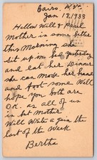
Antique West Virginia Postcard CAIRO 1933 Family Health Message $11.99
1933 Cairo Egypt Excavation Photo Dr. Selim Hassan Pyramid City Giza Tomb 8x10 $250.00
Cairo Egypt Stereoview Keystone View Co. 1933 Geographic Unit 2 $12.99
|
|
|
Shopping Cart  |

|
Recently Viewed |
|
Latest Items |
|
Facebook |
Secure Websites

|
