

|
Site Categories |
|
Featured Items |

Poodle, Spaghetti Trim, Ucagco


|
1950 US AIR FORCE Navigation Chart Map JAPAN Honshu Tokyo Osaka Nanpō Islands For Sale


When you click on links to various merchants on this site and make a purchase, this can result in this site earning a commission. Affiliate programs and affiliations include, but are not limited to, the eBay Partner Network.

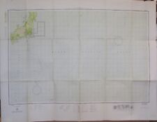
1950 US AIR FORCE Navigation Chart Map JAPAN Honshu Tokyo Osaka Nanpō Islands:
$49.99
Large-formatfold-out 1950 U.S. Air Force Long Range Navigation Chart covering part ofthe island of Honshu, the archipelago of Nanpo Shoto, including Iwo Jima,and a vast swath of the Pacific Ocean. - This map measures a verygenerous 102x 131 cm [40" x 51¾"] and is drawn on a scale of1:3,000,000.
- It is identified as the "Japan" sheet (LR-18), 6thEdition,September 1950.
- The coverage area is bounded by longitude 135° E to 170°Eand latitude 40° N to 20° N.
- The coverage area extends from Akita, Japan to the Mariana Islands.Among the other named places and features are Kyoto, Kobe, Yokohama, Kanazawa,Nagoya, and the island chain of Nanpo Shoto, including the Bonin Islandsand the Volcano Islands.
- The map also labels navigational aids and delineates four "DangerZones" in the offshore waters of Honshu.
- Condition: This map is in excellentcondition,bright and clean, with no rips,tears, or writing. It folds to 13½" x 8½" and is blank on theback, with no printing on the reverse side. Please see the scans andfeel free to ask any questions.
- Buy with confidence! We are always happy to combineshipping on the purchase of multiple items — just make sure to pay foreverythingat one time, not by SixBit's eCommerce Solution
|
|
Related Items: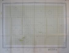
1950 US AIR FORCE Navigation Chart Map FIJI SAMOA TONGA Gilbert & Ellice Islands $49.99
1950 US AIR FORCE Navigation Chart Map JAPAN Honshu Tokyo Osaka Nanpō Islands $49.99
1950 SHELL OIL Tour Guide US ROUTE 30 Astoria Oregon Cheyenne Wyoming Twin Falls $14.99
|
|
|
Shopping Cart  |

|
Recently Viewed |
|
Latest Items |
|
Facebook |
Secure Websites

|
