When you click on links to various merchants on this site and make a purchase, this can result in this site earning a commission. Affiliate programs and affiliations include, but are not limited to, the eBay Partner Network.
\"An Authentic Original Map Not A Modern Reproduction\"
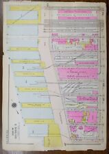
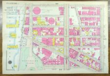
Offered for your consideration is a beautiful vintage original hand-colored map showing the Pulitzer fountain, Carnegie Hall, and neighborhoods bordering Central Park to the south. Bounded by 7th avenue to the west, 5th avenue to the east, Central Park South to the north, and W. 53rd Street to the south. This vintage 16 1/2\" x 11 1/2\" map is in VERY GOOD condition with light tone, soil, and edge wear as shown in pictures, from the Atlas of New York City, Borough of Manhattan, published in 1916 by G.W. Bromley, also known as the Land Atlas. On the reverse is a map of the adjoining neighborhood directly to the east, bounded by 5th avenue to the west, 3rd avenue to the east, East 59th Street to the north and East 53rd Street to the South, as shown in the last 3 pictures.
We sell originals only, no reproductions.
A copy of the title page is included with your purchase.
Your map will be shipped in sturdy waterproof tube via USPS priority mail, insured.
Thank you