When you click on links to various merchants on this site and make a purchase, this can result in this site earning a commission. Affiliate programs and affiliations include, but are not limited to, the eBay Partner Network.
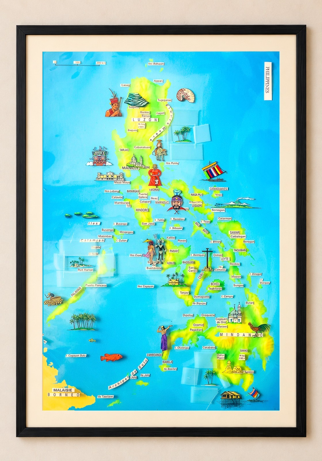
Carte illustrée originale des Philippines — Denis Horvath, 1989
Pièce unique. Original de fabrication dessiné et peint à la main par l\'illustrateur-cartographe français Denis Horvath pour le magazine Grands Reportages (n°88, 1989). Ce n\'est ni un tirage, ni une reproduction, ni une affiche : c\'est la maquette originale qui a servi à l\'impression de la carte dans le magazine.
Un dossier de fabrication complet
Avant la cartographie numérique, une carte de presse se construisait en superposant plusieurs feuilles séparées, réunies au moment de la photogravure. Ce lot les conserve toutes, chacune annotée de la main du cartographe à l\'intention du photograveur :
- Le fond géographique à l\'aérographe, seul — Luzon, Mindoro, Panay, Negros, Cebu, Leyte, Samar, Palawan et Mindanao modelés en dégradés de vert et de jaune sur un aplat bleu, chaque île découpée à la main. Aucun texte, aucune vignette.
- Le film des vignettes, annoté « Les Philippines – Vignettes – À réserver partout ».
- Le film de la toponymie, annoté « NOIR TEXTE », en lettrage transfert, de Laoag à Tawitawi.
- Le film du réseau routier, annoté « JAUNE 100% – à réserver dans le fond simili ».
Le sujet
L\'archipel entier, de Luzon à l\'archipel de Sulu, avec ses villes et ses sommets cotés (Mt. Pulog 2 928 m, Mt. Mayon 2 417 m, Mt. Apo 2 965 m). Une trentaine de vignettes peintes à la main : guerrier ifugao, rizières de Banaue, jeepney, cathédrale de Manille, masque de Moriones, carabao, vinta à voile rayée, Mayon en éruption, danseurs Ati-Atihan, croix de Magellan à Cebu, bahay kubo, mosquée de Marawi, coq de combat, maison badjao sur pilotis.
Authentification
Le verso porte le cachet d\'atelier « Denis HORVATH – Illustration », le titre manuscrit « Les Philippines » et la référence de production « GR88 ». Le numéro de téléphone du cachet est au format français à huit chiffres, abandonné en octobre 1996 : la réalisation est donc bien antérieure à cette date.
Provenance
Archives de la rédaction de Grands Reportages. Conservée par un ancien collaborateur du magazine au moment où ces documents de fabrication étaient mis au de la planche : environ 50 x 35 cm
Échelle : 1/4 000 000 (échelle graphique portée sur la planche : 5 cm = 200 km)Toponymie selon l\'usage éditorial français de la fin des années 1980 (Bantoc, Banue, Marinduc, Mt. Pulog)Technique mixte — aérographe, dessin et peinture à la main sur films, lettrage transfertÉtat : bon état d\'origine. Bandes adhésives de montage jaunies en tête de planche, repères de report au crayon, légères ondulations des films, salissures d\'atelier sur les bords. Aucun manque ni déchirure dans l\'image.Non signée au recto ; cachet d\'atelier au versoVendue non encadréeLe cadre et le passe-partout visibles sur les photos ne sont pas compris dans la vente.Expédition à plat, protégée entre plusieurs supports rigides, en envoi suivi et assuré.
Philippines — Original Hand-Painted Map Artwork by Denis Horvath, 1989
One of a kind. This is the original hand-painted artwork used to print the map of the Philippines in the French magazine Grands Reportages (issue 88, 1989). Not a print, not a reproduction, not a poster — the original artboard itself.
A complete pre-digital production set
Before digital cartography, a magazine map was built by layering separate sheets, combined at the photoengraving stage. This lot preserves them all, each annotated by hand by the cartographer for the engraver:
- The airbrushed base, on its own — Luzon, Mindoro, Panay, Negros, Cebu, Leyte, Samar, Palawan and Mindanao modelled in graded greens and yellows over a flat blue sea, every island cut by hand. No text, no vignettes.
- The vignette film, annotated « Vignettes – to be reserved throughout ».
- The lettering film, annotated « BLACK TEXT », place names in transfer lettering from Laoag to Tawitawi.
- The road network film, annotated « YELLOW 100% ».
Subject
The whole archipelago, from Luzon to the Sulu archipelago, with cities and spot heights (Mt. Pulog 2,928 m, Mt. Mayon 2,417 m, Mt. Apo 2,965 m). Around thirty hand-painted vignettes: Ifugao warrior, Banaue rice terraces, jeepney, Manila cathedral, Moriones mask, carabao, vinta with striped sail, erupting Mayon, Ati-Atihan dancers, Magellan\'s Cross in Cebu, bahay kubo, Marawi mosque, fighting cock, Badjao stilt house.
Attribution
The reverse bears the cartographer\'s studio stamp « Denis HORVATH – Illustration », his handwritten title « Les Philippines » and the production reference « GR88 ». The telephone number on the stamp is in the French eight-digit format discontinued in October 1996, placing the work well before that date.
Provenance
From the editorial archives of Grands Reportages, kept by a former staff member of the magazine when these production documents were being discarded.
Details
- Artboard approx. 50 x 35 cm (19.7 x 13.8 in)
- Scale: 1:4,000,000 (graphic scale bar on the artboard: 5 cm = 200 km)
<- Place names follow late-1980s French editorial usage (Bantoc, Banue, Marinduc, Mt. Pulog)
- Mixed media — airbrush, hand drawing and painting on film, transfer lettering
- Condition: good original condition. Yellowed mounting tape at the head of the board, pencil registration marks, slight waviness of the films, studio soiling at the edges. No losses or tears in the image.
- Unsigned on the front; studio stamp on the reverse
- Sold unframed
- The frame and mount shown in the photographs are not included in the sale.
Shipped flat, protected between rigid boards, tracked and insured. Worldwide shipping.