

|
Site Categories |
|
Featured Items |

Poodle, Spaghetti Trim, Ucagco


|
1953 ILLINOIS Official State Highway Road Map Route 66 Chicago Springfield Elgin For Sale


When you click on links to various merchants on this site and make a purchase, this can result in this site earning a commission. Affiliate programs and affiliations include, but are not limited to, the eBay Partner Network.

1953 ILLINOIS Official State Highway Road Map Route 66 Chicago Springfield Elgin:
$12.99
Handsomefold-out 1953 official highway map of Illinois, printed more than 70years ago. - This map opens to a generous32¾" x 22" and has great detail on oldhighwayalignments, route numbers, and road surfaces, including U.S.Routes 6, 30, 40, 50, and 66, with cartography by H.M. Gousha.
- On the reverse side there is a large map of the Chicago area and insetplans ofRockford, Elgin, Aurora, Kankakee, Joliet, Peoria, Quincy, Danville,Decatur,Alton, Springfield, and other cities.
- The was issued by Charles F. Carpentier, Illinois Secretary of State,in 1953 and isdated on the cover. The code in the lower margin is AA-1.
- Condition: This map is in excellentcondition, bright and clean,with no marks, rips, ortears. Pleasesee the scans and feel free to ask any questions.
- Buy with confidence! We are always happy to combineshipping onthe purchase of multiple items — just make sure to pay for everythingat one time, not by SixBit's eCommerce Solution
|
|
Related Items: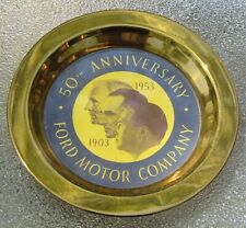
1953 Ford 50th Anniversary Dealership Dish Max Brothers Wilmington Illinois NOS $49.99
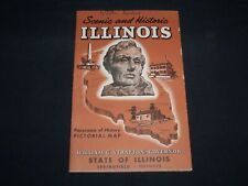
1953 SCENIC AND HISTORIC ILLINOIS FOLD-OUT MAP - J 8769 $45.00
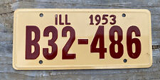
1953 Illinois Wheaties metal bicycle license plate cereal premium $15.65
|
|
|
Shopping Cart  |

|
Recently Viewed |
|
Latest Items |
|
Facebook |
Secure Websites

|
