

|
Site Categories |
|
Featured Items |

Poodle, Spaghetti Trim, Ucagco


|
1943 WAR MAP Pacific Ocean Hawaii Iwo Jima Saipan Luzon Japan Guam New Guinea For Sale


When you click on links to various merchants on this site and make a purchase, this can result in this site earning a commission. Affiliate programs and affiliations include, but are not limited to, the eBay Partner Network.

1943 WAR MAP Pacific Ocean Hawaii Iwo Jima Saipan Luzon Japan Guam New Guinea :
$24.99
Large-formatfold-out 1943 map of the Theater of War in the Pacific Ocean, printedmorethan 80 years ago. - This map shows the vastsweep of the PacificOcean, from Asia and Australia to the Americas, roughly centered on theHawaiian Islands.
- It opens to a generous 27" x 37" and is drawn on a scale of1:27,500,000 or 434 miles to the inch at the Equator.
- The map locates naval bases and railroads, and it shows mandates andpossessions, with wonderful detail throughout, including dozens ofislands and islandgroups (Iwo Jima, Saipan, Wake, Luzon,Borneo, Tarawa, New Guinea, the Marianas, Carolines, Marshalls, NewHebrides, Samoa, Tonga, andthe Solomons, wherethe Battle of Guadacanal earlier in the year had been a decisive andstrategically important victory for the Allies).
- Other details include the DefenseHighway across Australia, air-line distances between strategic points,steamship routes, typical storm tracks, upper limits of drift ice, andmore.
- There are 54 insets in the upper and lower areas of themap giving a closer look at many of the islands.
- This map was compiled by the cartographic section of the NationalGeographic Society and was issued as a supplement to the September 1943NationalGeographic Magazine.
- Condition: It is in excellentcondition, bright and clean, with nomarks, rips, or tears. It is blank on the back, with no printing on thereverse side. It foldsto 6¾" x 9½". Pleasesee the scans and feel free to ask any questions.
- Buy with confidence! We arealways happy to combineshipping onthe purchase of multiple items — just make sure to pay for everythingat one time, not by SixBit's eCommerce Solution
|
|
Related Items: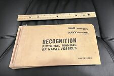
WWII Recognition Pictorial Manual of Naval Vessels, 1943, War & Navy Dept $65.00
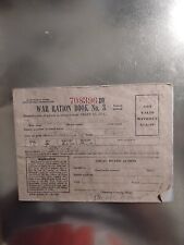
1943 War Rations $65.00

Original WWII 1943 American Red Cross War Fund Schlaikjer Poster Genuine Poster $230.00
|
|
|
Shopping Cart  |

|
Recently Viewed |
|
Latest Items |
|
Facebook |
Secure Websites

|
