When you click on links to various merchants on this site and make a purchase, this can result in this site earning a commission. Affiliate programs and affiliations include, but are not limited to, the eBay Partner Network.
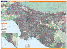
PROSERIES WALL MAP: LOS ANGELES & ORANGE COUNTIES (R)
DESCRIPTIONRand McNally\'s ProSeries wall map of Los Angeles & Orange Counties is ideal for anyone needing a comprehensive representation of the region for planning, routing, or reference. It\'s a great choice for business and sales strategy, urban development, social work outreach, education, and marketing.Note: This map is not available for gift wrapping. Please allow 7-10 days for shipping.
Laminated wall map printed with UV-resistant ink to help prevent color fadingMap details include airports, hospitals, railroads, points of interest, shopping centers, parks, golf and country clubs, post offices, police and fire stations, schools and educational institutions, government buildings, mileage circles, block numbers, city limits and annexations, ZIP codes and much moreHanging kit with rails for easy mountingCOVERAGE AREACoverage area extends:
North to the Los Angeles city limit, San FernandoSouth to Newport Beach on main map; to the Orange/San Diego County boundary on inset mapEast to Ontario, CoronaWest to the Pacific Ocean, Malibu, Simi ValleyPRODUCT DETAILSDimensions: 80\" x 60\"; Scale (in feet): 1:4,910. Copyright 2008.


")