When you click on links to various merchants on this site and make a purchase, this can result in this site earning a commission. Affiliate programs and affiliations include, but are not limited to, the eBay Partner Network.
PROSERIES WALL MAP: GREAT LAKES (R)
DESCRIPTION
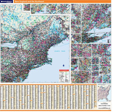
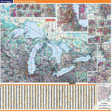
Rand McNally\'s ProSeries wall map of the Great Lakes area is ideal for anyone needing a comprehensive representation of the region for planning, routing, or reference. It\'s a great choice for business and sales strategy, urban development, social work outreach, education, and marketing.Note: This map is not available for gift wrapping. Please allow 7-10 days for shipping. Copyright 2009.
Durable (3 mm thick) lamination for writing on and wiping offEasy-to-read map with clear city and highway detailUV-resistant ink to help prevent color fadingInset maps of major cities (see below)Comprehensive city indexMileage chart and driving times map between main citiesHanging kit with rails for easy mounting just about anywhereIdeal for business, education, planning, or reference planningMap indications include:
Interstates, federal highways, and state highwaysCities and townsMajor waterways, rivers, and lakesState and national parksNational forests and monumentsUniversitiesMilitary installationsAirportsMajor geographic featuresCOVERAGE AREACoverage area: E. Minnesota, E. Iowa, Wisconsin, N. Illinois, N. Indiana, Michigan, N. Ohio, Pennsylvania, W. New York, and S. Ontario
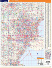
Inset maps: Duluth, Green Bay, Appleton, Cedar Rapids, Madison, Rockford, Quad Cities, Milwaukee, Chicago, Detroit
PRODUCT DETAILSMap specs:
Dimensions: 60\" x 60\"Scale: 1\" = 17.5 miles


")