When you click on links to various merchants on this site and make a purchase, this can result in this site earning a commission. Affiliate programs and affiliations include, but are not limited to, the eBay Partner Network.
Original 1862 Ceded Part Of Dakota Territory Showing Progress US Land Survey Map Original 1862 Ceded Part Of Dakota Territory Showing Progress US Land Survey Map
Click images to enlarge
Description
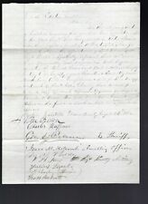
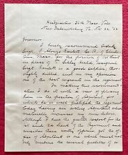
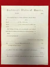
Up for your consideration is an Antique October 1st 1862 Ceded Part of Dakota Territory showing the progress of U.S. Land Survey during 1962. This Map is 13 Inches X 14 Inches, it is in Very Good Condition with the original left margin trimmed close. This Surveyor Map has a Certificate of Authenticity. Please enlarge the photos to see the exact condition of this item.Don't miss the opportunity to add this Antique October 1st 1862 Ceded Part of Dakota Territory showing the progress of U.S. Land Survey during 1862 to your collection.
Images sell!
Get Supersized Images & Free Image HostingCreate your brand with Auctiva's
Customizable Templates.
Attention Sellers - Get Templates
Image Hosting, Scheduling at Auctiva.com.
Track Page Views With
Auctiva's FREE Counter